Hispaniola is an island in the Caribbean archipelago which is known as the Greater Antilles. It is the most populous island in the West Indies and the region's second largest after Cuba.

India lies on the Indian Plate, the northern part of the Indo-Australian Plate, whose continental crust forms the Indian subcontinent. The country is situated north of the equator between 8°4' north to 37°6' north latitude and 68°7' east to 97°25' east longitude. It is the seventh-largest country in the world, with a total area of 3,287,263 square kilometres (1,269,219 sq mi). India measures 3,214 km (1,997 mi) from north to south and 2,933 km (1,822 mi) from east to west. It has a land frontier of 15,200 km (9,445 mi) and a coastline of 7,516.6 km (4,671 mi).

Myanmar is the northwesternmost country of mainland Southeast Asia. It lies along the Indian and Eurasian Plates, to the southeast of the Himalayas. To its west is the Bay of Bengal and to its south is the Andaman Sea. It is strategically located near major Indian Ocean shipping lanes. The neighboring countries are China, India, Bangladesh, Thailand and Laos.
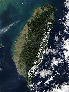
Taiwan, officially the Republic of China (ROC), is an island country in East Asia. The main island of Taiwan, known historically in English as Formosa, makes up 99% of the area controlled by the ROC, measuring 35,808 square kilometres (13,826 sq mi) and lying some 180 kilometres (112 mi) across the Taiwan Strait from the southeastern coast of mainland China. The East China Sea lies to its north, the Philippine Sea to its east, the Luzon Strait directly to its south and the South China Sea to its southwest. Smaller islands include a number in the Taiwan Strait including the Penghu archipelago, the Kinmen and Matsu Islands near the Chinese coast, and some of the South China Sea Islands.
The is a grammatical article in English, denoting persons or things already mentioned, under discussion, implied or otherwise presumed familiar to listeners, readers or speakers. It is the definite article in English. The is the most commonly used word in the English language; studies and analyses of texts have found it to account for seven percent of all printed English-language words. It is derived from gendered articles in Old English which combined in Middle English and now has a single form used with pronouns of either gender. The word can be used with both singular and plural nouns and with a noun that starts with any letter. This is different from many other languages which have different forms of the definite article for different genders or numbers.
Queensland is the second largest state in Australia. It contains 472 separate protected areas with a total land area of 69,388 km2 (26,791 sq mi). 223 of these are National parks, which is the highest number of any Australian state or territory, totaling 65,871 km2 (25,433 sq mi). Seven others are Scientific National Parks, totaling 522 km2 (202 sq mi).
The Aleutian Range is a major mountain range located in southwest Alaska. It extends from Chakachamna Lake to Unimak Island, which is at the tip of the Alaska Peninsula. It includes all of the mountains of the Peninsula. The Aleutian Range is special because of its large number of active volcanoes, which are also part of the larger Aleutian Arc. The mainland part of the range is about 600 miles (1000 km) long. The Aleutian Islands are (geologically) a partially submerged western extension of the range that stretches for another 1,600 km (1000 mi). However the official designation "Aleutian Range" includes only the mainland peaks and the peaks on Unimak Island. The range is almost entirely roadless wilderness. Katmai National Park and Preserve, a large national park within the range, must be reached by boat or plane.

Barrier islands are coastal landforms and a type of dune system that are exceptionally flat or lumpy areas of sand that form by wave and tidal action parallel to the mainland coast. They usually occur in chains, consisting of anything from a few islands to more than a dozen. They are subject to change during storms and other action, but absorb energy and protect the coastlines and create areas of protected waters where wetlands may flourish. A barrier chain may extend uninterrupted for over a hundred kilometers, excepting the tidal inlets that separate the islands, the longest and widest being Padre Island of Texas. Sometimes an important inlet may close permanently, transforming an island into a peninsula, thus creating a barrier peninsula. The length and width of barriers and overall morphology of barrier coasts are related to parameters including tidal range, wave energy, sediment supply, sea-level trends, and basement controls. The amount of vegetation on the barrier has a large impact on the height and evolution of the island.
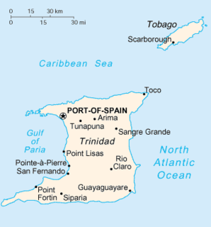
Trinidad is the larger and more populous of the two major islands of Trinidad and Tobago. The island lies 11 km (6.8 mi) off the northeastern coast of Venezuela and sits on the continental shelf of South America. It is often referred to as the southernmost island in the Caribbean. With an area of 5,131 km2 (1,981 sq mi), it is also the fifth largest in the West Indies.

Endemism is the state of a species being native to a single defined geographic location, such as an island, state, nation, country or other defined zone; organisms that are indigenous to a place are not endemic to it if they are also found elsewhere. For example, the Cape sugarbird is exclusively found in southwestern South Africa and is therefore said to be endemic to that particular part of the world. The extreme opposite of an endemic species is one with a cosmopolitan distribution, having a global or widespread range.

The American Cordillera is a chain of mountain ranges (cordilleras) that consists of an almost continuous sequence of mountain ranges that form the western "backbone" of North America, South America and Central America. It is also the backbone of the volcanic arc that forms the eastern half of the Pacific Ring of Fire.

The Madrean Sky Islands are enclaves of Madrean pine-oak woodlands, found at higher elevations in a complex of small mountain ranges in southern and southeastern Arizona, southwestern New Mexico, and northwestern Mexico. The sky islands are surrounded at lower elevations by the Sonoran and Chihuahuan deserts. The northern west–east perimeter of the sky island region merges into the higher elevation eastern Mogollon Rim and the White Mountains of eastern Arizona.

Antigua, also known as Waladli or Wadadli by the native population, is an island in the Lesser Antilles. It is one of the Leeward Islands in the Caribbean region and the main island of the country of Antigua and Barbuda. Antigua and Barbuda became an independent state within the Commonwealth of Nations on 1 November 1981.

The Ronald Reagan Ballistic Missile Defense Test Site, commonly referred to as the Reagan Test Site, is a missile test range in Marshall Islands. It covers about 750,000 square miles (1,900,000 km2) and includes rocket launch sites at the Kwajalein Atoll, Wake Island, and Aur Atoll. It primarily functions as a test facility for U.S. missile defense and space research programs. The Reagan Test Site is under the command of the US Army Kwajalein Atoll, or USAKA.

The Arctic Cordillera is a terrestrial ecozone in northern Canada characterized by a vast, deeply dissected chain of mountain ranges extending along the northeastern flank of the Canadian Arctic Archipelago from Ellesmere Island to the northeasternmost part of the Labrador Peninsula in northern Labrador and northern Quebec, Canada. It spans most of the eastern coast of Nunavut with high glaciated peaks rising through ice fields and some of Canada's largest ice caps, including the Penny Ice Cap on Baffin Island. It is bounded to the east by Baffin Bay, Davis Strait and the Labrador Sea while its northern portion is bounded by the Arctic Ocean.

Ascension Island is an isolated volcanic island, 7°56′ south of the Equator in the South Atlantic Ocean. It is about 1,000 miles (1,600 km) from the coast of Africa and 1,400 miles (2,300 km) from the coast of Brazil. It is governed as part of the British Overseas Territory of Saint Helena, Ascension and Tristan da Cunha, of which the main island, Saint Helena, is around 800 miles (1,300 km) to the southeast. The territory also includes the sparsely populated Tristan da Cunha archipelago, 2,300 miles (3,700 km) to the south, about halfway to the Antarctic Circle.

Greece is a country of the Balkans, in Southeastern Europe, bordered to the north by Albania, North Macedonia and Bulgaria; to the east by Turkey, and is surrounded to the east by the Aegean Sea, to the south by the Cretan and the Libyan Seas, and to the west by the Ionian Sea which separates Greece from Italy.
Range Island is an uninhabited island in Qikiqtaaluk Region, Nunavut, Canada. Located in Hudson Bay, it is a member of the Belcher Islands group. It lies at the mouth of Omarolluk Sound and measures a mere 500 m along its longest axis. Other islands in the immediate vicinity include: