
The prehistory of Papua New Guinea can be traced to about 50,000 - 60,000 years ago, when people first migrated towards the Australian continent. The written history began when European navigators first sighted New Guinea in the early part of the 17th century.

The geography of Papua New Guinea describes the eastern half of the island of New Guinea, the islands of New Ireland, New Britain and Bougainville, and smaller nearby islands. Together these make up the nation of Papua New Guinea in tropical Oceania, located in the western edge of the Pacific Ocean.
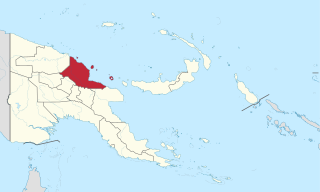
Madang is a province of Papua New Guinea. The province is on the northern coast of mainland Papua New Guinea and has many of the country's highest peaks, active volcanoes and its biggest mix of languages. The capital is the town of Madang.

Western New Guinea, also known as West Papua, Indonesian Papua, or simply Papua, is the portion of the island of New Guinea occupied by Indonesia since 1962. Considered to be a part of the Australian continent, the territory is mostly in the Southern Hemisphere and includes the Schouten and Raja Ampat archipelagoes. The region is predominantly covered with ancient rainforest where numerous traditional tribes live such as the Dani of the Baliem Valley although a large proportion of the population live in or near coastal areas with the largest city being Jayapura.

The Fly River is the third longest river in the island of New Guinea, after the Sepik River and Mamberamo River with a total length of 1,060 km (660 mi) and the largest by volume of discharge in Oceania, the largest in the world without a single dam in its catchment, and overall the 25th-largest primary river in the world by discharge volume. It is located in the southwest of Papua New Guinea and Papua Province of Indonesia. It rises in the Victor Emanuel Range arm of the Star Mountains, and crosses the south-western lowlands before flowing into the Gulf of Papua in a large delta.

Mount Wilhelm is the highest mountain in Papua New Guinea at 4,509 metres (14,793 ft). It is part of the Bismarck Range and the peak is the point where three provinces, Simbu, Jiwaka and Madang, meet. The peak is also known as Enduwa Kombuglu, or Kombugl'o Dimbin, in the local Kuman.

Western Province is a coastal province in southwestern Papua New Guinea, bordering the Indonesian province of Papua. The provincial capital is Daru. The largest town in the province is Tabubil. Other major settlements are Kiunga, Ningerum, Olsobip and Balimo.

East Sepik is a province in Papua New Guinea. Its capital is Wewak. East Sepik has an estimated population of 433,481 people and is 43,426 km square in size.
The Bismarck Range is a mountain range in the Western Highlands Province of Papua New Guinea. The range is named after the German Chancellor, Otto von Bismarck. From the 1880s to 1914 this part of the island was a German colony.

Puncak Trikora, until 1963 Wilhelmina Peak, is a 4,730 or 4,750-metre-high (15,584 ft) mountain in the Papua province of Indonesia on New Guinea. It lies in the eastern part of the Sudirman (Nassau) Range of the Maoke Mountains.
The Star Mountains are a mountain range in western Papua New Guinea and the eastern end of Papua province, Indonesia, stretching from the eastern end of Indonesia to the Hindenburg Range in Papua New Guinea.

The Bewani Mountains form a mountain range in northwestern Papua New Guinea. Together with the Torricelli Mountains and Prince Alexander Mountains it forms the North Coastal Range of Papua New Guinea. The highest point of the mountains is at 1,960 m.
Kratke Range is a mountain range in Eastern Highlands, Papua New Guinea. Several rivers, including Aziana, Yaiga, Lamari and Ramu originate in the mountains. Many endemic birds live in the mountains.
Mount Victoria is the highest point in the Owen Stanley Ranges in Central Province, Papua New Guinea at 4,038 metres (13,248 ft). It lies approximately 75 km north-north-east of Port Moresby and can be seen on a clear day from the city.
The Hans Meyer Range is a mountain range in the southern part of New Ireland, Papua New Guinea. This range was named after German geographer Hans Meyer (1858–1929).

The New Guinea Highlands, also known as the Central Range or Central Cordillera, is a long chain of mountain ranges on the island of New Guinea, including the island's tallest peak, Puncak Jaya 16,024 ft (4,884 m), the highest mountain in Oceania. The range is home to many intermountain river valleys, many of which support thriving agricultural communities. The highlands run generally east-west the length of the island, which is divided politically between Indonesia in the west and Papua New Guinea in the east.

New Guinea is the world's second-largest island, and with an area of 785,753 km2 (303,381 sq mi), the largest island in the Southern Hemisphere. Located in Melanesia in the southwestern Pacific Ocean, it is separated by the 150 km wide Torres Strait from the Australian continent. Numerous smaller islands are located to the west and east. The eastern half of the island is the major land mass of the independent state of Papua New Guinea. The western half, known as Western New Guinea or West Papua, forms a part of Indonesia and is organized as the provinces of Papua and West Papua.

The Lorentz River is located in the Indonesian province of Papua in Western New Guinea, about 3500 km northeast of the Indonesian capital Jakarta. It originates in the central east-west mountain range of New Guinea, and flows southwards into the Arafura Sea at Flamingo Bay. During the first two Dutch expeditions to Southern New Guinea (1907–10) it was called Northern River. In 1910 it was renamed after the Dutch explorer Hendrikus Albertus Lorentz. After it became part of Indonesia, it was renamed to Unir, as in the language of the local Asmat people, while the Lorentz name is still in use.

The Sepik River is the longest river on the island of New Guinea, and after the Fly and the Mamberamo the third largest by volume. The majority of the river flows through the Papua New Guinea (PNG) provinces of Sandaun and East Sepik, with a small section flowing through the Indonesian province of Papua.

The Papuan Peninsula, also known as the Bird's Tail Peninsula, is a large peninsula in Papua New Guinea, southeast of the city of Lae, that makes up the southeastern portion of the island of New Guinea. The peninsula is the easternmost extent of the New Guinea Highlands and consists largely of the Owen Stanley Range, with peaks such as Mount Victoria and Mount Suckling. On the south coast is Port Moresby, the capital and largest city of Papua New Guinea.
