
The Arfak astrapia is a species of astrapia, a group of birds found in the birds-of-paradise family Paradiseidae.

The Bird's Head Peninsula or Doberai Peninsula, is a large peninsula that makes up the northwest portion of the island of New Guinea, comprising the Indonesian provinces of Southwest Papua and West Papua. It is often referred to as The Vogelkop, and is so named because its shape looks like a bird's head on the island of New Guinea. The peninsula at the opposite end of the island is called the Bird's Tail Peninsula. The peninsula just to the south is called the Bomberai Peninsula.

The Arfak Mountains is a mountain range found on the Bird's Head Peninsula in the Province of West Papua, Indonesia.
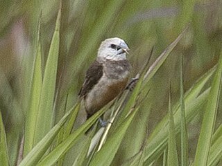
The grey-banded mannikin, or grey-banded munia, is a species of estrildid finch known to be found in Anggi Gigi, Tamrau Mountains, and Arfak Mountains in the Vogelkop Peninsula in north-western Papua, Indonesia. This species inhabits mid-mountain wet grassland and marshland. It also can be found on abandoned agricultural plots near human settlements.
The black-tailed dasyure is a species of marsupial in the family Dasyuridae.
The Arfak pygmy bandicoot is a species of marsupial in the family Peramelidae. It is endemic to the Arfak mountains in the Vogelkop Peninsula of West Papua, in Indonesia. Its natural habitat is subtropical or tropical moist montane forests. The population is unknown and threats may be human expansion and hunting but it is protected by Arfak Reserve.
The Pegunungan Arfak Nature Reserve lies in the north-east corner of the Bird's Head Peninsula in the Indonesian province of West Papua. It is located 25 km south of the provincial capital Manokwari. It spans from near the coast up to the highest point in the province, Pegunungan Arfak, at 2,955 m (9,695 ft).
New Guinea, lying within the tropics and with extensive mountain areas, comprises a wide range of ecoregions. These include rainforests, grasslands and mangrove.

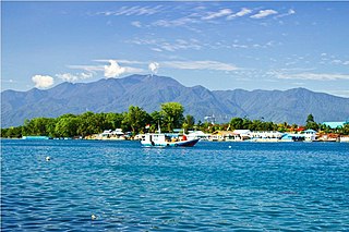
Sausapor is a small town and District in the Tambrauw Regency of Southwest Papua, Indonesia. The town is located on the northern coast of the Bird's Head Peninsula, also known as the Vogelkop Peninsula. According to the 2010 census, the kecamatan has a population of 2,633, and more recent figures reveal around 1000 people living in the main town of Sausapor. Sausapor is a major breeding ground for sea turtles and bird habitat.

Mount Arfak is the highest point in the province of West Papua. It is located on north-east side of the Bird's Head Peninsula. It is a popular hiking area and is the highest peak of the Arfak Mountains. From the summit, Manokwari can be seen. The summit of Mt. Arfak is temperate and dry with very hot, dry summer temperatures that average below 95 °F (35 °C) and mild, humid winter temperatures that average above 38 °F (3 °C). During the winter months, the mountain's summit receives frost usually and sometimes can get to 33 °F (0 °C) every now and then. Sometimes snow can fall on the summit, but not every year. Average rain amount per year is about 45 inches (1150 mm). The mountain is part of the Pegunungan Arfak Nature Reserve, a 683-square-kilometer (264 sq mi) protected area that protects parts of the Vogelkop montane rain forests ecoregion. The mountain is also the highest point in the Manokwari metropolitan area.
The Vogelkop mountain rat, Rattus arfakiensis, is a species of rat native to Indonesia. It is found only in the Bird's Head Peninsula of Papua Province, Indonesia.
Bon Irau, with an elevation of 2,501 metres (8,205 ft), is the highest peak in the Tamrau Mountains and the highest point in the province of West Papua outside of the Arfak Mountains. It is located in the north central region of the Bird's Head Peninsula and located around 20 kilometres (12 mi) from the grassy Kebar Valley.

The Kebar Valley is a large pleistocene/holocene intermontane valley found in the north central region of the Bird's Head Peninsula in the province of Southwest Papua. The valley is enclosed by the fault-bounded Tamrau Mountains at an area of 2,703 square kilometres (1,044 sq mi). Its depth averages from 500 to 600 m in the lower sections to around 900 to 1,400 m in the upper sections of the valley. The valley is located 130 km (81 mi) west of Manokwari and 190 km (120 mi) east of Sorong. The nearest major village to the valley is Saukorem. A notable path runs through the Kebar Valley connecting Saukorem to the settlement of Andai and reaches an altitude of 1,200 m (3,900 ft). This has created many villages throughout the area, leading to a growing rice production in the central and eastern regions of the valley. From north to south, the Kebar Valley ranges from 16 to 30 km wide, and from east to west, it extends from 94 to 116 km in length.

The Arfak catbird is a species of bowerbird (Ptilonorhynchidae) which can be found in the Bird's Head (Vogelkop) Peninsula in western New Guinea.
Heptapleurum angiense is a flowering plant in the family Araliaceae. It is a tree endemic to western New Guinea.

The Vogelkop–Aru lowland rain forests is a tropical moist forest ecoregion in Indonesia. The ecoregion covers the peninsular lowlands of western New Guinea, along with the Aru Islands and other nearby islands.
The Vogelkop montane rain forests is a tropical moist forest ecoregion in western New Guinea. The ecoregion covers the mountains of western New Guinea's Bird's Head and Bomberai peninsulas.
Nothofagus carrii is a species of tree in the family Nothofagaceae. It is endemic to New Guinea.

