Kebar Valley

Last updated
Kebar Valley
Lembah Kebar
Kebar Valley.jpg
A tall grass field, with a large broadleaf forest in the background.
Location map Indonesia Bird's Head Peninsular.png
Red pog.svg
Kebar Valley
Indonesia location map.svg
Red pog.svg
Kebar Valley
Location in Indonesia
Length94 to 116 km (58 to 72 mi)
Width16 to 30 km (9.9 to 18.6 mi)
Area2,703 km2 (1,044 sq mi)
Depth500 to 1,400 m (1,600 to 4,600 ft)
Geology
TypeAlluvial
Geography
Location Manokwari Regency, Arfak Mountains Regency, Tambrauw Regency, West Papua, Bird's Head Peninsula, Indonesia
Population centersMany tribal villages of the Karoon, Abun, Dore and Wabia people
Borders on Tamrau Mountains (north), Arfak Mountains (south)
Coordinates 0°49′22″S133°01′15″E / 0.822682°S 133.020742°E / -0.822682; 133.020742
RiversKasi River, Api River, Apriri River

The Kebar Valley (Indonesian: Lembah Kebar) is a large pleistocene/holocene intermontane valley found in the north central region of the Bird's Head Peninsula in the province of Southwest Papua. The valley is enclosed by the fault-bounded Tamrau Mountains at an area of 2,703 square kilometres (1,044 sq mi). Its depth averages from 500 to 600 m (1,600 to 2,000 ft) [1] in the lower sections to around 900 to 1,400 m (3,000 to 4,600 ft) in the upper sections of the valley. The valley is located 130 km (81 mi) west of Manokwari and 190 km (120 mi) east of Sorong. The nearest major village to the valley is Saukorem. A notable path runs through the Kebar Valley connecting Saukorem to the settlement of Andai and reaches an altitude of 1,200 m (3,900 ft). This has created many villages throughout the area, leading to a growing rice production in the central and eastern regions of the valley. [2] From north to south, the Kebar Valley ranges from 16 to 30 km (9.9 to 18.6 mi) wide, and from east to west, it extends from 94 to 116 km (58 to 72 mi) in length.

Contents

Geography

The valley floor is leveled and gently tilted to three degrees, providing a division between the Arfak Mountains in the south, and the Tamrau Mountains in the north. Along its margins are several small alluvial cones, and terrace remnants of high level lake or alluvial deposits that rest along the north side of the valley. The major drainage area is the Kasi River. However, the Api River and Apriri River are two other rivers that cross this valley and supply water to the southeast lowland swamp areas. At the western end of the valley, quaternary basin sediments are cut by the Kasi River and exposed in terraces up to 30 m (98 ft) high. Throughout the valley are many natural pastures, with the largest one located in the central region and has an area of 218 km2 (84 sq mi). Primary fauna found in the valley is the Rusa Deer (Cervus timorensis), which are mostly found close to the flat regions of the central and eastern parts of the valley, encompassing the grassland and forest regions. However, it is common to find the deer across the grassland, looking for shelter in the hilly forests of the western regions of the valley. This hilly grassland area can be described as the pathway of water from highland areas to the flatland areas flowing to the east through the gullies. The physical characteristic of the soil in the Kebar Valley has been described as sandy in texture with little coherence structure in the central and western regions, along with a sandy clay loam in coherent plastic bolus structure along the eastern region.

Kebar Valley, with the Tamrau Mountains in the background. Panorama of the Kebar Valley.jpg
Kebar Valley, with the Tamrau Mountains in the background.

Climate

Encompassing the Vogelkop montane rain forests ecoregion, the Kebar Valley has a tropical savanna climate, characterized mostly by its tall grass fields and broadleaf forests. The weather in the valley is subject to seasonal influence of the northwest monsoon from November to March, and the southeast trade winds from June to September. Limited meteorological observations indicate a relatively dry season for half of the year along the northern and central part of the valley, especially when the trade winds are blowing from the southeast. Rainfall is high throughout the Kebar Valley, with an average up to 3,500 millimetres (140 in) annually. Temperatures are uniformly high in the lowlands, which range from about 23 to 30 °C (73 to 86 °F), decreasing with higher elevation towards the Tamrau Mountains to a mean daily temperature from 8 to 16 °C (46 to 61 °F), with an average rainfall from 1,500 to 2,000 millimetres (59 to 79 in). Relative humidity is also uniformly high in the valley, ranging from 80 to 100 percent. Morning clouds and ground fog may hamper aircraft operations in regions surrounding the valley during dry season.

Demographics

For agricultural purposes, many of the people live in the grassland regions of the Kebar Valley. Kebar Valley Lowlands.jpg
For agricultural purposes, many of the people live in the grassland regions of the Kebar Valley.

The Kebar Valley is home to the Karoon, Abun, Dore and the Wabia people who made their main home in the village of Saukorem. [3] The growing populations in the valley resulted from Christian missionaries that moved through this region of the Bird's Head Peninsula. [1] The people living here are reported to have children not only with partners of other families, but with cousins and distant relatives which may affect the parent's views of which children are truly "biological" or not. [4] The people of the valley, Saukorem and this region of the Bird's Head Peninsula are said to produce wooden figures which are known as Korwar figures. [5] They are often made with glass beads for eyes and a neckband made of bark-cloth and with the skulls of deceased family members. [6] The Korwar figures in particular which are made with skulls are said to provide an abode for spirits of the departed and are believed to safeguard the vital force which is contained within the skull of the deceased. [5] The locals are also known for producing bark-cloth. [7]

Resources

Related Research Articles

<span class="mw-page-title-main">West Papua (province)</span> Province in Indonesia

West Papua, formerly Irian Jaya Barat, is an Indonesian province located in Indonesia Papua. It covers most of the two western peninsulas of the island of New Guinea, the eastern half of the Bird's Head Peninsula and the whole of the Bomberai Peninsula, along with nearby smaller islands. The province is bordered to the north by the Pacific Ocean, to the west by Southwest Papua Province, the Halmahera Sea and the Ceram Sea, to the south by the Banda Sea, and to the east by the province of Central Papua and the Cenderawasih Bay. Manokwari is the province's capital and largest city. With an estimated population of 569,570 in mid-2023, West Papua is the least populous province in Indonesia after South Papua, following the separation off in 2022 of the western half of the Bird's Head Peninsula to create the new province of Southwest Papua, containing 52% of what had been West Papua's population.

<span class="mw-page-title-main">Western New Guinea</span> Region of Indonesia on the island of New Guinea

Western New Guinea, also known as Papua, Indonesian New Guinea, and Indonesian Papua, is the western, formerly Dutch presently Indonesian, half of the island of New Guinea, granted to Indonesia in 1962. Given the island is alternatively named Papua, the region is also called West Papua.

<span class="mw-page-title-main">Javan rusa</span> Species of deer

The Javan rusa or Sunda sambar is a large deer species native to Indonesia and East Timor. Introduced populations exist in a wide variety of locations in the Southern Hemisphere.

<span class="mw-page-title-main">Arfak astrapia</span> Species of bird

The Arfak astrapia is a species of astrapia, a group of birds found in the birds-of-paradise family Paradiseidae.

<span class="mw-page-title-main">Bird's Head Peninsula</span> Peninsula in Indonesia

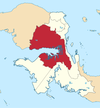
The Bird's Head Peninsula or Doberai Peninsula, is a large peninsula that makes up the northwest portion of the island of New Guinea, comprising the Indonesian provinces of Southwest Papua and West Papua. It is often referred to as The Vogelkop, and is so named because its shape looks like a bird's head on the island of New Guinea. The peninsula at the opposite end of the island is called the Bird's Tail Peninsula. The peninsula just to the south is called the Bomberai Peninsula.

<span class="mw-page-title-main">Arfak Mountains</span> Mountain range in Indonesia

The Arfak Mountains is a mountain range found on the Bird's Head Peninsula in the Province of West Papua, Indonesia.

<span class="mw-page-title-main">Grey-banded mannikin</span> Species of bird

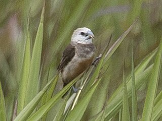
The grey-banded mannikin, or grey-banded munia, is a species of estrildid finch known to be found in Anggi Gigi, Tamrau Mountains, and Arfak Mountains in the Vogelkop Peninsula in north-western Papua, Indonesia. This species inhabits mid-mountain wet grassland and marshland. It also can be found on abandoned agricultural plots near human settlements.

<span class="mw-page-title-main">Black mannikin</span> Species of bird

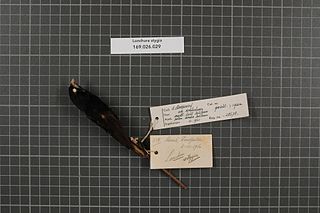
The black mannikin or black munia is a species of estrildid finch found in New Guinea, from Mandum to Lake Daviumbu, Papua New Guinea. It is commonly found in flocks of maximum 20 birds, inhabiting savannas, wetlands, but sometimes they were also seen at rice crops.

<span class="mw-page-title-main">New Guinea</span> Island in the Pacific Ocean

New Guinea is the world's second-largest island, with an area of 785,753 km2 (303,381 sq mi). Located in Melanesia in the southwestern Pacific Ocean, the island is separated from Australia by the 150-kilometre wide Torres Strait, though both landmasses lie on the same continental shelf, and were united during episodes of low sea level in the Pleistocene glaciations as the combined landmass of Sahul. Numerous smaller islands are located to the west and east. The island's name was given by Spanish explorer Yñigo Ortiz de Retez during his maritime expedition of 1545 due to the resemblance of the indigenous peoples of the island to those in the African region of Guinea.

<span class="mw-page-title-main">Trans-Fly savanna and grasslands</span> Ecoregion in New Guinea

The Trans Fly savanna and grasslands are a lowland ecoregion on the south coast of the island of New Guinea in both the Indonesian and Papua New Guinean sides of the island. With their monsoon and dry season climate these grasslands are quite different from the tropical rainforest that covers most of the island and resemble the landscape of northern Australia which lies to the south.

Saukorem is a coastal village in Amberbaken, Tambrauw Regency of Southwest Papua, Indonesia, located about 125 km (75 mi) north-northwest of Manokwari. The town is located on the northern coast of the Bird's Head Peninsula and administratively it is the principal settlement of Amberbaken subdistrict of the Tambrauw.

<span class="mw-page-title-main">Sausapor</span> District and Town in Southwest Papua, Indonesia

Sausapor is a small town and District in the Tambrauw Regency of Southwest Papua, Indonesia. The town is located on the northern coast of the Bird's Head Peninsula, also known as the Vogelkop Peninsula. According to the 2010 census, the kecamatan has a population of 2,633, and more recent figures reveal around 1000 people living in the main town of Sausapor. Sausapor is a major breeding ground for sea turtles and bird habitat.

<span class="mw-page-title-main">Bintuni Bay Regency</span> Regency in West Papua, Indonesia

Teluk Bintuni Regency or Bintuni Bay Regency is a regency of West Papua Province of Indonesia. It covers an area of 18,637 km2, comprising administrative districts on three sides of Bintuni Bay, a gulf that separates the Bird's Head Peninsula and Bomberai Peninsula which together form the main geographical constituents of the province; it had a population of 52,422 at the 2010 Census and 87,083 at the 2020 Census; the official estimate as at mid 2023 was 90,101. The administrative centre is the town of Bintuni.

<span class="mw-page-title-main">Mount Arfak</span>

Mount Arfak is the highest point in the province of West Papua. It is located on north-east side of the Bird's Head Peninsula. It is a popular hiking area and is the highest peak of the Arfak Mountains. From the summit, Manokwari can be seen. The summit of Mt. Arfak is temperate and dry with very hot, dry summer temperatures that average below 95 °F (35 °C) and mild, humid winter temperatures that average above 38 °F (3 °C). During the winter months, the mountain's summit receives frost usually and sometimes can get to 33 °F (0 °C) every now and then. Sometimes snow can fall on the summit, but not every year. Average rain amount per year is about 45 inches (1150 mm). The mountain is part of the Pegunungan Arfak Nature Reserve, a 683-square-kilometer (264 sq mi) protected area that protects parts of the Vogelkop montane rain forests ecoregion. The mountain is also the highest point in the Manokwari metropolitan area.

<span class="mw-page-title-main">Tamrau Mountains</span> Mountain range in Indonesia

The Tamrau Mountains, also known as the Tambrauw Mountains or the Tamarau Mountains, is a mountain range located in the north-central region of the Bird's Head Peninsula in the province of West Papua, Indonesia. It is made up of an isolated and lesser continuous mountain chain compared to the Arfak Mountains. The Tamrau and Arfak Mountains are both divided by the grassy Kebar Valley, which is the heartland of many indigenous people, with a variety of backgrounds. The Tamrau Mountains have been scantily surveyed. The mountains are an important and threatened site of biodiversity, part of the Vogelkop montane rain forests ecoregion.

Bon Irau, with an elevation of 2,501 metres (8,205 ft), is the highest peak in the Tamrau Mountains and the highest point in the province of West Papua outside of the Arfak Mountains. It is located in the north central region of the Bird's Head Peninsula and located around 20 kilometres (12 mi) from the grassy Kebar Valley.

<span class="mw-page-title-main">Sulawesi lowland rain forests</span> Ecoregion in Sulawesi, Indonesia

The Sulawesi lowland rain forests is a tropical moist forest ecoregion in Indonesia. The ecoregion includes the lowlands of Sulawesi and neighboring islands.

<span class="mw-page-title-main">Vogelkop–Aru lowland rain forests</span> Ecoregion in Indonesia

The Vogelkop–Aru lowland rain forests is a tropical moist forest ecoregion in Indonesia. The ecoregion covers the peninsular lowlands of western New Guinea, along with the Aru Islands and other nearby islands.

<span class="mw-page-title-main">Vogelkop montane rain forests</span> Ecoregion in New Guinea

The Vogelkop montane rain forests is a tropical moist forest ecoregion in western New Guinea. The ecoregion covers the mountains of western New Guinea's Bird's Head and Bomberai peninsulas.

The Bird's Neck Isthmus is an isthmus in western New Guinea. It connects the main mass of the island to its two large western peninsulas, the Bird's Head Peninsula, also known as the Vogelkop or Doberai Peninsula, and the Bomberai Peninsula. The isthmus is mostly covered in lowland tropical rain forest.

References

  1. 1 2 Gregerson, Marilyn; Sterner, Joyce (March 1998). Symbolism and ritual in Irian Jaya. Cenderawasih University. p. 104. ISBN   978-1-55671-025-4 . Retrieved 20 December 2010.
  2. Nova Guinea. Maatschappij ter Bevordering van het Natuurkundig Onderzoek der Nederlandsche Koloniën, E.J. Brill. 1909. p.  1 . Retrieved 20 December 2010.
  3. Kamma, Freerk Ch (1975). Religious texts of the oral tradition from Western New-Guinea (Irian Jaya). BRILL. pp. 49–. ISBN   978-90-04-05694-7 . Retrieved 20 December 2010.
  4. Miedema, Jelle; Reesink, Ger P. (2004). One head, many faces: new perspectives on the Bird's Head Peninsula of New Guinea. KITLV Press. pp. 49–50. doi:10.1163/9789004454385. ISBN   978-90-6718-229-4 . Retrieved 20 December 2010.
  5. 1 2 Bühler, Alfred; Barrow, Terence; Mountford, Charles Pearcy (1968). The art of the South Sea Islands: including Australia and New Zealand,. Greystone Press. p. 35. Retrieved 20 December 2010.
  6. Bühler, Alfred (1962). The art of the South Sea Islands, including Australia and New Zealand. Crown Publishers. p. 36. Retrieved 20 December 2010.
  7. Howard, Michael Carlton (2006). Bark-cloth in Southeast Asia. White Lotus Press. p. 184. ISBN   978-974-480-096-1 . Retrieved 20 December 2010.