The geography of Papua New Guinea describes the eastern half of the island of New Guinea, the islands of New Ireland, New Britain and Bougainville, and smaller nearby islands. Together these make up the nation of Papua New Guinea in tropical Oceania, located in the western edge of the Pacific Ocean.

New Britain is the largest island in the Bismarck Archipelago, part of the Islands Region of Papua New Guinea. It is separated from New Guinea by a northwest corner of the Solomon Sea and from New Ireland by St. George's Channel. The main towns of New Britain are Rabaul/Kokopo and Kimbe. The island is roughly the size of Taiwan.

The Solomon Islands rain forests are a terrestrial ecoregion covering the Solomon Islands archipelago.

Kaiser-Wilhelmsland formed part of German New Guinea, the South Pacific protectorate of the German Empire. Named in honour of Wilhelm I, who reigned as German Emperor from 1871 to 1888, it included the northern part of present-day Papua New Guinea. From 1884 until 1920 the territory was a protectorate of the German Empire. Kaiser-Wilhelmsland, the Bismarck Archipelago, the northern Solomon Islands, the Caroline Islands, Palau, Nauru, the Northern Mariana Islands, and the Marshall Islands comprised German New Guinea.

Western New Guinea, also known as Papua, Indonesian New Guinea, and Indonesian Papua, is the western half of the island of New Guinea, formerly Dutch and granted to Indonesia in 1962. Given the island is alternatively named Papua, the region is also called West Papua.

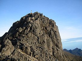
Mount Wilhelm is the highest mountain in Papua New Guinea at 4,509 metres (14,793 ft). It is part of the Bismarck Range and the peak is the point where three provinces, Chimbu, Jiwaka and Madang, meet. The peak is also known as Enduwa Kombuglu, or Kombugl'o Dimbin, in the local Kuman language.
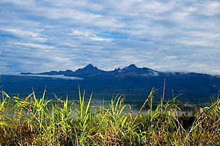
Mount Giluwe is the second highest mountain in Papua New Guinea at 4,367 metres (14,327 ft), and the fifth highest peak on the island of New Guinea. It is located in the Southern Highlands province and is an old shield volcano with vast alpine grasslands. Ancient volcanic plugs form its two summits, with the central peak the highest and an east peak about 2 kilometres (1.2 mi) away at 4,300 m (14,108 ft). Giluwe has the distinction of being the highest volcano on the Australian continent and Oceania, and is thus one of the Volcanic Seven Summits.

The dwarf cassowary, also known as Bennett's cassowary, little cassowary, mountain cassowary or muruk, is the smallest of the three extant species of cassowaries.

The eastern long-beaked echidna, also known as Barton's long-beaked echidna, is one of three species from the genus Zaglossus to occur in New Guinea. It is found mainly in the eastern half at elevations between 2,000 and 3,000 metres.

Blyth's hornbill, also known as the Papuan hornbill, is a large hornbill inhabiting the forest canopy in Wallacea and Melanesia. Its local name in Tok Pisin is kokomo.

New Ireland, or Latangai, is a large island in Papua New Guinea, approximately 7,404 km2 (2,859 sq mi) in area with c. 120,000 people. It is named after the island of Ireland. It is the largest island of New Ireland Province, lying northeast of the island of New Britain. Both islands are part of the Bismarck Archipelago, named after Otto von Bismarck, and they are separated by Saint George's Channel.
Beck's tree frog is a species of frog in the subfamily Pelodryadinae. It is endemic to Papua New Guinea. Its natural habitats are tropical moist montane forests, grasslands and streams. It was first described by the British biologist and herpetologist Arthur Loveridge in 1945 and is named in honour of the American ornithologist and explorer Rollo Beck who led the Whitney South Seas Expedition in the 1920s, collecting bird and other specimens from thousands of islands in the South Pacific.

The painted tiger parrot is a species of parrot in the family Psittaculidae. It is mainly found in Papua New Guinea.

The Papuan mountain pigeon is a species of bird in the pigeon family, Columbidae. It is found in the Bacan Islands, New Guinea, the D'Entrecasteaux Islands, and the Bismarck Archipelago, where it inhabits primary forest, montane forest, and lowlands. It is a medium-sized species of pigeon, being 33–36 cm (13–14 in) long and weighing 259 g (9.1 oz) on average. Adult males have slate-grey upperparts, chestnut-maroon throats and bellies, whitish breasts, and a pale grey terminal tail band. The lores and orbital region are bright red. Females are similar, but have grayish breasts and grey edges to the throat feathers.

The white-winged robin is a species of bird in the family Petroicidae.

The New Guinea Highlands, also known as the Central Range or Central Cordillera, is a long chain of mountain ranges on the island of New Guinea, including the island's highest peak, Puncak Jaya, Indonesia, 16,024 ft (4,884 m), the highest mountain in Oceania. The range is home to many intermountain river valleys, many of which support thriving agricultural communities. The highlands run generally east-west the length of the island, which is divided politically between Indonesia in the west and Papua New Guinea in the east. These mountains stretch from the Weyland Mountains starting in Wondama Bay Regency in the west to the Milne Bay Province in the east.

New Guinea is the world's second-largest island, with an area of 785,753 km2 (303,381 sq mi). Located in Melanesia in the southwestern Pacific Ocean, the island is separated from Australia by the 150-kilometre wide Torres Strait, though both landmasses lie on the same continental shelf, and were united during episodes of low sea level in the Pleistocene glaciations as the combined landmass of Sahul. Numerous smaller islands are located to the west and east. The island's name was given by Spanish explorer Yñigo Ortiz de Retez during his maritime expedition of 1545 due to the resemblance of the indigenous peoples of the island to those in the African region of Guinea.

The Central Range montane rain forests is a tropical moist forest ecoregion on the island of New Guinea. The ecoregion covers the Central Range of the New Guinea Highlands, which extends along the spine of the island. The montane rain forests of the ecoregion are distinct from the surrounding lowland forests, and are home to many endemic plants and animals.
Finschia is a genus of three recognised species of large trees, constituting part of the plant family Proteaceae. They grow naturally in New Guinea and its surrounding region, in habitats from luxuriant lowland rainforests to steep highland forests.
The New Britain–New Ireland montane rain forests is a tropical moist forest ecoregion in Papua New Guinea. The ecoregion includes the mountain rain forests on the islands of New Britain and New Ireland, which lie northeast of New Guinea.