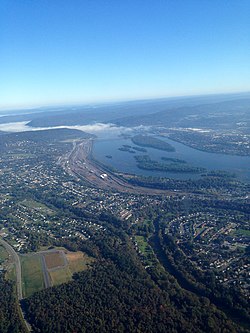
Harrisburg is the capital city of the U.S. commonwealth of Pennsylvania and the seat of Dauphin County. With a population of 50,099 as of 2020, Harrisburg is the ninth-most populous city in Pennsylvania. It is the larger principal city of the Harrisburg–Carlisle metropolitan statistical area, also known as the Susquehanna Valley, which had a population of 591,712 in 2020 and is the fourth-most populous metro area in Pennsylvania. Harrisburg is situated on the east bank of the Susquehanna River and is located 83 miles (134 km) southwest of Allentown and 107 miles (172 km) northwest of Philadelphia.

Maytown is an unincorporated community and census-designated place (CDP) in Lancaster County, Pennsylvania, United States. The population was 4,098 at the 2020 census.
Camp Hill is a borough in Cumberland County, Pennsylvania, United States. It is 3 miles (5 km) southwest of Harrisburg and is part of the Harrisburg–Carlisle metropolitan statistical area. The population was 8,130 at the 2020 census. There are many large corporations based in nearby East Pennsboro Township and Wormleysburg that use the Camp Hill postal address, including the Harsco Corporation and until 2022 the Rite Aid Corporation.
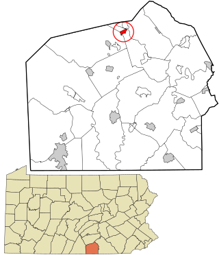
East Pennsboro Township is a township in Cumberland County, Pennsylvania, United States. The population was 20,228 at the 2010 census, up from 18,254 at the 2000 census. East Pennsboro is the second most populous municipality in Cumberland County. The township is located along the western banks of the Susquehanna River, across from Harrisburg. There are many large corporations based in East Pennsboro Township that use the Camp Hill postal address, including the Rite Aid Corporation and Gannett Fleming.

Hampden Township is the largest municipality by population in Cumberland County, Pennsylvania, United States. The population was 28,044 at the 2010 census, up from 24,135 at the 2000 census.

Mechanicsburg is a borough in Cumberland County, Pennsylvania, United States. The borough is eight miles (13 km) west of Harrisburg. It is part of the Harrisburg–Carlisle metropolitan statistical area. As of the 2010 census, it had a population of 8,981. The 2020 census reported the population at 9,311.

Wormleysburg is a borough in Cumberland County, Pennsylvania, United States. The population was 3,070 at the 2010 census. It is part of the Harrisburg–Carlisle Metropolitan Statistical Area.
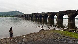
Susquehanna Township is a township in Dauphin County, Pennsylvania, United States. The population was 26,736 at the time of the 2020 census. This represents a 11.2% increase from the 2010 census count of 24,036. Susquehanna Township has the postal ZIP codes 17109 and 17110, which maintain the Harrisburg place name designation. The township is a suburb of Harrisburg and is connected to Marysville by the Rockville Bridge, the world's longest stone-arch rail bridge at the time of its completion.

Campbelltown is an unincorporated community and census-designated place (CDP) in Lebanon County, Pennsylvania, United States. The population was 3,616 at the 2010 census. It is located east of Hershey at the intersection of U.S. Route 322 and Pennsylvania Route 117 and is located in the Harrisburg metropolitan area.
Pleasant Hill is an unincorporated community and census-designated place (CDP) in Lebanon County, Pennsylvania, United States. The population was 2,643 at the 2010 census, up from 2,301 at the 2000 census.

Mountain Top is an unincorporated area and census-designated place (CDP) in Luzerne County, Pennsylvania, United States. As of the 2010 census, its population was 10,982.
Salunga is an unincorporated community and census-designated place (CDP) in West Hempfield and East Hempfield townships in Lancaster County, Pennsylvania, United States. As of the 2010 census, the population was 2,695. The community was once part of the Salunga-Landisville CDP, before splitting into two separate CDPs for the 2010 census, the other being Landisville.

Cumberland County is a county in the Commonwealth of Pennsylvania. As of the 2020 census, the population was 259,469. Its county seat is Carlisle. The county is part of the South Central Pennsylvania region of the state.
Summerdale is an unincorporated community located in East Pennsboro Township, Cumberland County, Pennsylvania, United States. As of 2020, the community had an estimated population of 705. Central Pennsylvania College and the Capital Area Intermediate Unit are located in Summerdale. It is part of the Harrisburg–Carlisle Metropolitan Statistical Area.

West Fairview, formerly a borough, is now a census-designated place (CDP) located at the confluence of the Susquehanna River and the Conodoguinet Creek in East Pennsboro Township, Cumberland County, Pennsylvania, United States. As of the 2020 census, the village had a population of 1,138.
Stevens is an unincorporated community and census-designated place (CDP) in Lancaster County, Pennsylvania, United States. As of the 2010 census, it had a population of 612. The Stevens post office has ZIP code 17578.
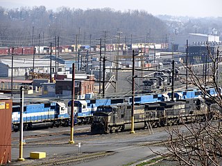
Enola Yard is a large rail yard located in East Pennsboro Township, Pennsylvania, along the western shore of the Susquehanna River in Harrisburg, Pennsylvania.
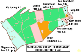
The East Pennsboro Area School District is a midsized, suburban, public school district located in Cumberland County, Pennsylvania, US. The district is one of the 496 public school districts of Pennsylvania. East Pennsboro Area School District serves: East Pennsboro Township and the Villages of Enola, Summerdale, West Fairview and parts of the Borough of Camp Hill. According to 2000 federal census data, it served a resident population of 18,254 people. By 2010, the District's population increased to 20,267 people. In 2009, the East Pennsboro Area School District residents' per capita income was $22,517, while the median family income was $54,142. The educational attainment levels for the School District population were 92.2% high school graduates and 29.5% college graduates.
Gardners is an unincorporated community in Adams County, Pennsylvania and a census-designated place that includes portions of Adams and Cumberland counties in Pennsylvania, United States. The village of Gardners is located off Pennsylvania Route 34, in Tyrone Township, in northern Adams County. As of the 2020 census, the population of the village of Gardners was 137. The zip code for the United States Post Office in the village of Gardners is 17324. This zip code covers surrounding villages and areas in Adams and Cumberland counties, including Goodyear, Hunter's Run, Idaville, Pine Grove Furnace State Park, and Uriah.
The West Shore of the Harrisburg area is a group of suburbs of Harrisburg, Pennsylvania which are located to the west of the Susquehanna River. The Susquehanna River is very wide near Harrisburg, and that contributes to the perception, at least among the local inhabitants, that the East Shore and West Shore have distinct identities. The West Shore area includes parts of eastern Cumberland County, southeastern Perry County and northern York County.