Enon, North Carolina

Last updated
Enon
ENONBC.jpg
Enon Baptist Church as it looks today
USA North Carolina location map.svg
Red pog.svg
Enon
Location within the state of North Carolina
Coordinates: 36°08′24″N80°28′08″W / 36.14000°N 80.46889°W / 36.14000; -80.46889
Country United States
State North Carolina
County Yadkin
Elevation
[1]
886 ft (270 m)
Time zone UTC-5 (Eastern (EST))
  Summer (DST) UTC-4 (EDT)
GNIS feature ID984806 [1]

Enon is an unincorporated community in eastern Yadkin County, North Carolina, United States. The community, which is centered on Enon Baptist Church, is in the Forbush Township and in the East Bend ZIP code zone (27018). It is a Piedmont Triad community.

Contents

The community is bordered by the Yadkin River and Forsyth County to the east, Huntsville and Forbush and Logan creeks to the south, Flint Hill to the north and Looney Creek to the west. [2]

History

Pre-history

Native Americans were living along the Yadkin River at Enon going back to at least the early Woodland period (500 B.C.-100 A.D.), according to a 1998 archeological survey. [3] A v-shaped stone fish weir, built and used by Native Americans to trap spawning fish, was identified north of the Old U.S. 421 Bridge in Enon.

Founding of community

The fertile river bottoms began to draw a few European settlers who followed the Great Wagon Road in the mid-18th century. By 1850, the area included large plantations along the Yadkin River, which were dependent on slave labor, as well as a few smaller farms.

The area was first known as Red Plains, likely for the red soil in the area. A school and post office were located there. Because there was no road nearby, only paths through the woods led to the school. [4] A post office called Mana was at one time located in the area. [5]

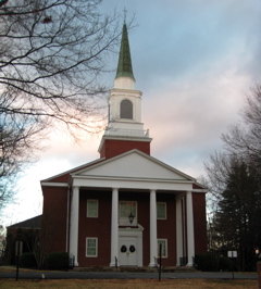
Enon Baptist Church was founded in 1858. Members first met at the Red Plains School, near the home of Tyre Glen. The name Enon was chosen because of its proximity of the Yadkin River. Enon is an alternate spelling for Ænon, a Greek word for spring. [6] The church began with eight members, including John, a slave of Tyre Glen. The first church building included a balcony for slave members.

Civil War period

Tyre Glen or Tyree Glenn (1800–1875) built one of the largest plantations in western North Carolina, in Enon. The estate, known as Glenwood, once had 360 slaves and 6,000 acres (24 km2). [7] The 15-room house, with its Doric columns, was completed in 1837. The soapstone foundation for the house came from Glen's own quarry. Recently, it was restored and is a privately owned residence. Glen's property included a dam, gristmill and a ferry at the Yadkin River.

Glen spent his early career as a slave trader and land broker, helping set up plantations in Mississippi. Glen's papers are available through Duke University Libraries and have been cited in recent books on the Civil War period. [8] Among the records, is a price table from the early 1850s that values slaves based on their ages. [9] Glenwood was a center for culture in the area. Prominent visitors included Nathan Rudolphus., the son of Sen. Stephen A. Douglas; North Carolina Gov. Zebulon Vance; and North Carolina Chief Justice Richard M. Pearson.

In 1863, a company of 50 uninvited Confederate troops of the 8th Battalion Georgia Infantry descended on Glenwood. In April 1863, Glen's rants against secession angered the officers, who instigated a plot to lure him from Glenwood and hang him as a traitor. The officers' plot was stopped by heavy rains that washed away the bridge at Deep Creek, and Glen returned to his home. [10]

In July 1864, William Alexander Conrad, a founding member of Enon Baptist Church and member of the Home Guard, was shot at Glenn's Ferry, trying to catch what he thought were three deserters who were crossing the river in a small boat. Conrad died several months later. Years after the war, it was learned that the men were Union soldiers who had escaped from prison and were on their way to Ohio. [11]

Glenwood was raided several times during the close of the Civil War. After the last raid, in April 1865, most of the slaves had fled, and there was neither a horse nor a head of cattle left. [12] As the Confederate army disbanded, troops marched along the ferry road that ran through the estate. For weeks, long tables were erected at each side of the house and family members and the few remaining freedmen gave food to all who stopped.

A partner in the slave trade with Glen, Isaac Jarratt (1812–1875), also settled in the Enon area. Jarratt, who served as a drummer boy during the War of 1812, bought the Davis Durrett plantation in 1835. Many of the Jarratt family papers, including letters and slave receipts, are located in the library at the University of North Carolina at Chapel Hill. [13] During the Civil War, Isaac Jarratt was captain of the Yadkin County Home Guard.

The Jarratt family is also tied to the families of Thomas Lanier Clingman and through marriage to Richard Clauselle Puryear of nearby Huntsville. [14] The Durrett-Jarratt House, on Old U.S. Highway 421, is listed on the National Register of Historic Places. [15]

Later development

The community remained isolated after the Civil War. In 1913, the first bridge across the Yadkin River at Enon was authorized by the North Carolina Legislature. The steel bridge was completed a short time before a sand-clay road was built in 1915. The road, which linked Winston-Salem to Yadkinville, was paved in 1925 and became part of U.S. Highway 421. [16] The highway gave the area easier access to Winston-Salem, which is less than 10 miles (16 km) east.

At least four country stores and a roller mill opened along the highway, offering gas and other conveniences to locals and travelers along the highway. However, the stores began closing in the 1960s after a new four-lane U.S. 421 was built a few miles south of the community. The former U.S. highway is now called Old U.S. 421.

In 1936, High Point began an ill-fated plan to build an 85-foot (26 m) deep lake and hydroelectric dam in an area that included portions the community. High Point bought up more than 14,000 acres (57 km2) along the Yadkin River for the Styers Ferry dam project and had spent about $1 million before it was stopped by the courts. Local farmers and Duke Power mobilized to fight the plan. The dam project went before the state Supreme Court seven times. Finally, the federal government ended the project during World War II because generators were needed for the war effort. [17]

Growth and development

Until recently, many Enon residents lived on family farms, and the area remained primarily rural. However, the community's proximity to Winston-Salem has made it more attractive as a bedroom community. Development in the western suburbs of Winston-Salem, especially in nearby Lewisville, has begun to move into the community. Land that for decades had been used for farming is being converted into housing developments.

Most residents work in nearby Winston-Salem. However, there are a few home-grown businesses that employ area residents. The largest is Johnson's Modern Electric, which has a home office near the Yadkin River on Old U.S. Highway 421. [18]

Education

Most children in the area attend Forbush Elementary School, a kindergarten through eighth-grade community school at Bloomtown Road and Old U.S. 421. The school, which first opened in 1935, is a source of pride in the community. The school's hunter's safety team has won the National Junior Youth Hunter Education Challenge, a National Rifle Association sponsored event, six times: 1989, 1990, 2005, 2006, 2007,2008 and 2009. [19] The 2007 team compiled a score of 7,580, 792 points over the second-place team from Utah, and took honors in all events. [20]

Forbush Elementary, one of five feeder schools for Forbush High School, was rebuilt after a 1986 countywide bond referendum. In 2002, a tower was built in front of the school to house the old bell that was used at Enon School, a three-teacher school built in 1908. [21] The bell was moved to the school when Enon School closed.

Recreation

Old U.S. 421 River Park is located just across the Yadkin River from Enon. The 1.58-acre (6,400 m2) park allows convenient access to the Yadkin River for fishing or canoeing. It is part of the Forsyth County park system.

Related Research Articles

<span class="mw-page-title-main">Yadkin County, North Carolina</span> County in North Carolina, United States

Yadkin County is located in the U.S. state of North Carolina. As of the 2020 census, the population was 37,214. Its county seat is Yadkinville. Yadkin County is included in the Winston-Salem, NC Metropolitan Statistical Area, which is also included in the Greensboro-Winston-Salem-High Point, NC Combined Statistical Area.

<span class="mw-page-title-main">Surry County, North Carolina</span> County in North Carolina, United States

Surry County is a county located in the U.S. state of North Carolina. As of the 2020 census, the population was 71,359. Its county seat is Dobson, and its largest city is Mount Airy.

<span class="mw-page-title-main">Forsyth County, North Carolina</span> County in North Carolina, United States

Forsyth County is located in the northwest Piedmont of the U.S. state of North Carolina. As of the 2020 census, the population was 382,590, making it the fourth-most populous county in North Carolina. Its county seat is Winston-Salem. Forsyth County is part of the Winston-Salem, NC, Metropolitan Statistical Area, which is also included in the Greensboro-Winston-Salem-High Point, NC, Combined Statistical Area. Portions of Forsyth County are in the Yadkin Valley wine region.

<span class="mw-page-title-main">Winston-Salem, North Carolina</span> City in North Carolina, United States

Winston-Salem is a city in and the county seat of Forsyth County, North Carolina, United States. In the 2020 census, the population was 249,545, making it the second-largest municipality in the Piedmont Triad region, the fifth-most populous city in North Carolina, the third-largest urban area in North Carolina, and the 90th-most-populous city in the United States. With a metropolitan population of 675,966, it is the fourth-largest metropolitan area in North Carolina. Winston-Salem is home to the tallest office building in the region, 100 North Main Street, formerly known as the Wachovia Building and now known locally as the Wells Fargo Center.

<span class="mw-page-title-main">East Bend, North Carolina</span> Town in North Carolina, United States

East Bend is a town in northeastern Yadkin County, North Carolina, United States. The population is 634 at the 2020 census. It is a Piedmont Triad community.

<span class="mw-page-title-main">Jonesville, North Carolina</span> Town in North Carolina, United States

Jonesville, originally called Allen's Settlement, is the oldest town in Yadkin County, North Carolina, United States. The population was 2,285 at the 2010 census. The town grew by nearly 800 residents in 2001 when it merged with neighboring Arlington. Recognized as the Heart of the Yadkin Valley, Jonesville is a gateway to the Blue Ridge Mountains, the Yadkin Valley Heritage/Cultural Corridor and to local wineries in the Swan Creek AVA and the larger Yadkin Valley AVA, as well as offering access to the Yadkin river.

<span class="mw-page-title-main">Piedmont Triad</span> Region in North Carolina

The Piedmont Triad is a metropolitan region in the north-central part of the U.S. state of North Carolina anchored by three cities: Greensboro, Winston-Salem, and High Point. This close group of cities lies in the Piedmont geographical region of the United States and forms the basis of the Greensboro–Winston-Salem–High Point, NC Combined Statistical Area. As of 2012, the Piedmont Triad has an estimated population of 1,611,243 making it the 33rd largest combined statistical area in the United States.

<span class="mw-page-title-main">Yadkin River</span> River in North Carolina, United States

The Yadkin River is one of the longest rivers in the US state of North Carolina, flowing 215 miles (346 km). It rises in the northwestern portion of the state near the Blue Ridge Parkway's Thunder Hill Overlook. Several parts of the river are impounded by dams for water, power, and flood control. The river becomes the Pee Dee River at the confluence of the Uwharrie River south of the community of Badin and east of the town of Albemarle. The river then flows into South Carolina near Cheraw, which is at the Fall Line. The entirety of the Yadkin River and the Great Pee Dee River is part of the Yadkin-Pee Dee River Basin.

Advance is an unincorporated community and census-designated place (CDP) in Davie County, North Carolina, United States. It is seventy-five miles northeast of Charlotte. As of the 2010 census it had a population of 1,138. It is located along North Carolina Highway 801 just south of Bermuda Run. Advance is part of the Piedmont Triad region of North Carolina.

<span class="mw-page-title-main">North Carolina Highway 67</span> State highway in North Carolina, US

North Carolina Highway 67 (NC 67) is a 40.9-mile-long (65.8 km) primary state highway in the U.S. state of North Carolina. The highway travels through Yadkin and Forsyth Counties between its western terminus at U.S. Route 21 Business in Jonesville and NC 150 in Winston-Salem. NC 67 primarily follows an east–west alignment and connects the towns of Jonesville, Boonville, and East Bend, along with the city of Winston-Salem.

<span class="mw-page-title-main">North Carolina Highway 150</span> State highway in North Carolina, US

North Carolina Highway 150 (NC 150) is a primary state highway in the U.S. state of North Carolina. It serves the Foothills and Piedmont Triad areas of the state, connecting the cities of Shelby, Mooresville, Salisbury and Winston-Salem.

Hamptonville is an unincorporated community located in southwestern Yadkin County, North Carolina, United States. Hamptonville is named for Henry Hampton (1750–1832), a colonel in the Revolutionary Army. Hampton set aside land for a town in 1806.

Alfred "Teen" Blackburn was one of the last surviving American enslaved persons with a clear recollection of slavery as an adult. He was known throughout Yadkin County, North Carolina for his strength, size and longevity. While enslaved, he served as a body servant for his owner, a Confederate soldier, during the Civil War. In 1929, state officials granted him a Class B pension in North Carolina, which has led some to mistakenly describe him as a Confederate veteran.

Siloam is an unincorporated community in southeastern Surry County, North Carolina, United States. The Yadkin River makes up the community's southern border, and the Ararat River flows between it and the community of Shoals to the east. It is a Piedmont Triad community.

Courtney is an unincorporated community in southeastern Yadkin County, North Carolina, United States.

Huntsville is a small unincorporated community in Yadkin County, North Carolina, United States. The community was formerly chartered in 1792 by Charles Hunt of Salisbury, NC and was chartered again in 1822. It has a Huntsville Volunteer Fire Department, and Huntsville Community Center which is in front of a baseball/softball field which is home to Huntsville little league.

<span class="mw-page-title-main">Forbush Township, Yadkin County, North Carolina</span>

Forbush Township is one of twelve townships in Yadkin County, North Carolina, United States. The township had a population of 3,695 according to the 2000 census.

<span class="mw-page-title-main">U.S. Route 421 in North Carolina</span> Highway in North Carolina

U.S. Route 421 (US 421) is part of the United States Numbered Highway System that runs from Fort Fisher, North Carolina to Michigan City, Indiana. In the U.S. state of North Carolina, US 421 travels 328 miles (528 km) from its southern terminus at Fort Fisher to the Tennessee state line near the community of Zionville, North Carolina. US 421 traverses the state from east to west travelling from the coastal plains to Appalachian Mountains. It provides an important connection between the cities of Wilmington, Sanford, Greensboro, Winston-Salem, and Boone. Despite being signed as north–south, much of the routing of US 421 in North Carolina runs in an east–west direction, particularly between Greensboro and the Tennessee state line. Portions of US 421 have been upgraded to freeway standards including the majority of its routing between Sanford and North Wilkesboro.

<span class="mw-page-title-main">Glenwood (Enon, North Carolina)</span> Historic house in North Carolina, United States

Glenwood is a historic plantation with a Greek Revival house and several outbuildings, located near Enon, Yadkin County, North Carolina.

<span class="mw-page-title-main">North Carolina Highway 133</span> State highway in North Carolina, US

North Carolina Highway 133 (NC 133) is a primary state highway in the U.S. state of North Carolina. It traverses 46.6 miles (75.0 km) from Oak Island Drive in Oak Island to NC 210 in Bells Crossroads. The route serves communities such as Southport, Belville, Leland, Wilmington, and Castle Hayne. Additionally, NC 133 serves as an entry point for Military Ocean Terminal Sunny Point located to its east. Much of NC 133 runs parallel to the Cape Fear River and Brunswick River between Southport and Belville. West of Wilmington, NC 133 runs concurrently with U.S. Route 17 (US 17), US 74, and US 76. The road follows another concurrency along US 74 and US 421, west of Downtown Wilmington, and crosses into New Hanover County on the Isabel Holmes Bridge. North of Wilmington, NC 133 exits to the north, serving several suburban communities north of Wilmington. NC 133 runs concurrently with US 117 through Castle Hayne, before bearing northwest toward Bells Crossroads.

References

  1. 1 2 U.S. Geological Survey Geographic Names Information System: Enon, North Carolina
  2. The Heritage of Yadkin County, Frances Harding Casstevens, editor, Page 221
  3. "Wake Forest University archeological survey of Yadkin River at Enon" Archived 2002-10-18 at the Library of Congress Web Archives, Wake Forest University
  4. An Illustrated History of Yadkin County, 1850-1980, by William E. Rutledge Jr., p. 72
  5. An Illustrated History of Yadkin County, 1850-1980, by William E. Rutledge Jr., Page 18
  6. "History of the Origin, Organization and Decidication of Enon Baptist Church, paper copied in 1930
  7. "Glenwood," article Harry's Guide, September 1936
  8. John Hope Franklin Collection, Duke University
  9. South Carolina Information Highway
  10. "As Seen by Granddaughter," The Charlotte Observer, May 30, 1926, by Bertha Glen Kyle, granddaughter of Tyre Glen
  11. The Civil War and Yadkin County, North Carolina, by Frances H. Casstevens, page 73
  12. "Glenwood," Harry's Guide, September 1936
  13. Manuscripts Department, University Library of the University of North Carolina at Chapel Hill
  14. The Heritage of Yadkin County, Frances Harding Casstevens editor, page 432
  15. "North Carolina Listings in the National Register of Historic Places by County". North Carolina State Historic Preservation Office. 22 October 2008. Archived from the original on 30 November 2012. Retrieved 16 July 2009.
  16. The Heritage of Yadkin County, Page 108
  17. "Overpowered," Winston-Salem Journal, July 1, 2001
  18. Johnson's Modern Electric Inc. main site Archived 2007-09-28 at the Wayback Machine
  19. North Carolina Wildlife Resources Commission press release [ permanent dead link ]
  20. "Milestones," Winston-Salem Journal, August 20, 2007
  21. Forbush Elementary School official site Archived 2009-05-07 at the Wayback Machine