East Bend, North Carolina

Last updated

East Bend, North Carolina
NCMap-doton-EastBend.PNG
Location of East Bend, North Carolina
Coordinates: 36°13′04″N80°30′30″W / 36.21778°N 80.50833°W / 36.21778; -80.50833
Country United States
State North Carolina
County Yadkin
Government
  Type Mayor-council government
  MayorArchie Hicks
Area
[1]
  Total1.31 sq mi (3.40 km2)
  Land1.31 sq mi (3.39 km2)
  Water0.01 sq mi (0.01 km2)
Elevation
[2]
1,056 ft (322 m)
Population
 (2020)
  Total634
  Density484.34/sq mi (187.07/km2)
Time zone UTC-5 (Eastern (EST))
  Summer (DST) UTC-4 (EDT)
ZIP code
27018
Area code 336
FIPS code 37-19320 [3]
GNIS feature ID2406412 [2]
Website eastbendnc.com

East Bend is a town in northeastern Yadkin County, North Carolina, United States. The population is 634 at the 2020 census. [4] It is a Piedmont Triad community.

Contents

Geography

According to the United States Census Bureau, the town has a total area of 1.3 square miles (3.4 km2), all land.

Demographics

Historical population
CensusPop.Note
1900 444
1910 52217.6%
1920 508−2.7%
1930 470−7.5%
1940 4945.1%
1950 475−3.8%
1960 446−6.1%
1970 4858.7%
1980 60224.1%
1990 6192.8%
2000 6596.5%
2010 612−7.1%
2020 6343.6%
U.S. Decennial Census [5]

As of the census [3] of 2000, there were 659 people, 271 households, and 188 families residing in the town. The population density was 514.8 inhabitants per square mile (198.8/km2). There were 304 housing units at an average density of 237.5 per square mile (91.7/km2). The racial makeup of the town was 95.14% White, 1.21% African American, 0.91% Native American, 0.15% Asian, 1.67% from other races, and 0.91% from two or more races. Hispanic or Latino of any race were 8.50% of the population.

There were 271 households, out of which 32.8% had children under the age of 18 living with them, 56.1% were married couples living together, 9.6% had a female householder with no husband present, and 30.6% were non-families. 28.8% of all households were made up of individuals, and 12.9% had someone living alone who was 65 years of age or older. The average household size was 2.43 and the average family size was 2.96.

In the town, the population was spread out, with 25.6% under the age of 18, 9.0% from 18 to 24, 30.3% from 25 to 44, 22.5% from 45 to 64, and 12.6% who were 65 years of age or older. The median age was 37 years. For every 100 females, there were 94.4 males. For every 100 females age 18 and over, there were 89.9 males.

The median income for a household in the town was $39,333, and the median income for a family was $49,000. Males had a median income of $32,321 versus $26,667 for females. The per capita income for the town was $17,611. About 3.3% of families and 6.3% of the population were below the poverty line, including 4.4% of those under age 18 and 14.1% of those age 65 or over.

Nearby cities/towns

History

Native American settlement

One of the most significant Native American excavation sites in North Carolina is located near the Yadkin River west of the town of Donnaha. Donnaha was listed in the National Register of Historic Places on December 6, 1978. [6] Experts from Wake Forest University believe this was the site of a village of at least 100 Sioux Indians dating to the late Woodland Period.

Earl Norman, an East Bend artifact collector, donated 5,000 pieces of his collection of more than 10,000 relics to the North Carolina Department of Archives and History in 1960. [7]

Establishment of town

East Bend was first known as Banner's Store. It was named for merchant Martin Luther Banner. Early settler Martin Luther Banner later moved west and founded Banner Elk, North Carolina. [8]

On March 7, 1887, the General Assembly incorporated the town of East Bend and named it after the east bend of the Yadkin River. [9] Officers were mayor J.H Johnson; commissioners Dr. Evan Benbow, J.H. Jenkins, J.A. Martin, Dr. W.E. Benbow, and J.G. Huff; and constable J.M. Whittington.

J.G. Huff established the first buggy-manufacturing business in town in 1873. The Huff Buggy Factory, built in 1893, was said to be the largest buggy factory in the South. Huff closed the buggy works about 1920 and began operating a funeral home, which is still owned and operated by his heirs. [10]

The Yadkin Ripple , a weekly newspaper still published in Yadkin County, began in East Bend in 1896.

In 1904, the town's population was 444 and it boasted a hotel, two buggy factories, a tobacco bag factory, a bank, and several stores. However, a decision by the Southern Railroad to bypass the town 1890 put a damper on the town's growth. Roger Moore, now a film critic for The Orlando Sentinel , compared East Bend to Lake Wobegon, "It's a homey town with a lot of history and a few 'might-have-beens,' " Moore wrote in The Winston-Salem Journal . [11]

The Yadkin County Agricultural Fair was held in East Bend from 1914 until 1978. The fair was first held at the old schoolhouse and in later years was moved to a tract east of town on North Carolina Highway 67. The fairgrounds were later converted to a community softball park. [12]

Education

Public schools

Most children in town attend East Bend Elementary School, a kindergarten through sixth-grade public community school at N.C. Highway 67 Bypass and Flint Hill Road. The school traces its history back to the East Bend Academy, which operated from 1856-1889. In 1890, it became known as Union High School. Most of the high school and its records burned in 1964. It was rebuilt at the site and became an elementary-only school after countywide consolidation in 1967. [13]

East Bend is one of five feeder schools for Forbush High School and the newly built middle school, which is located in the ZIP code area of East Bend south of town. Two other elementary schools are located in the East Bend ZIP code area, Forbush and Fall Creek.

Attractions

Notable people

Related Research Articles

<span class="mw-page-title-main">Yadkin County, North Carolina</span> County in North Carolina, United States

Yadkin County is located in the U.S. state of North Carolina. As of the 2020 census, the population was 37,214. Its county seat is Yadkinville. Yadkin County is included in the Winston-Salem, NC Metropolitan Statistical Area, which is also included in the Greensboro–Winston-Salem–High Point, NC Combined Statistical Area.

<span class="mw-page-title-main">Surry County, North Carolina</span> County in North Carolina, United States

Surry County is a county located in the U.S. state of North Carolina. As of the 2020 census, the population was 71,359. Its county seat is Dobson, and its largest city is Mount Airy.

<span class="mw-page-title-main">Stokes County, North Carolina</span> County in North Carolina, United States

Stokes County is a county located in the U.S. state of North Carolina. As of the 2020 census, the population was 44,520. Its county seat is Danbury.

<span class="mw-page-title-main">Forsyth County, North Carolina</span> County in North Carolina, United States

Forsyth County is located in the northwest Piedmont of the U.S. state of North Carolina. As of the 2020 census, the population was 382,590, making it the fourth-most populous county in North Carolina. Its county seat is Winston-Salem. Forsyth County is part of the Winston-Salem, NC, Metropolitan Statistical Area, which is also included in the Greensboro–Winston-Salem–High Point, NC, Combined Statistical Area. Portions of Forsyth County are in the Yadkin Valley wine region.

<span class="mw-page-title-main">Davie County, North Carolina</span> County in North Carolina, United States

Davie County is a county located in the U.S. state of North Carolina. As of the 2020 census, the population was 42,712. Its county seat is Mocksville.

Bermuda Run is a town in Davie County, North Carolina, United States. The population was 1,725 at the 2010 census. It was incorporated in 1999 as a fully gated residential community near country clubs and golf courses like the Bermuda Run Country Club, Oak Valley Golf Club, and Tanglewood Park. In 2000, the town annexed into neighboring Hillsdale, picking up a commercial district. The town rests on the western bank of the Yadkin River along U.S. Route 158 and North Carolina Highway 801. Interstate 40 provides express access to Winston-Salem, the town's nearest urban center. In 2012, Kinderton Village was voluntarily annexed by the town of Bermuda Run.

<span class="mw-page-title-main">Clemmons, North Carolina</span> Village in North Carolina

Clemmons is a village in Forsyth County, North Carolina, United States and a suburb of Winston-Salem. The population was 21,177 at the 2020 census, with an estimated population of 21,517 in 2021.

<span class="mw-page-title-main">Lewisville, North Carolina</span> Town in North Carolina, United States

Lewisville is a town in Forsyth County, North Carolina, United States. The population was 13,388 at the 2020 census, up from 12,639 in 2010. It is a Piedmont Triad community.

<span class="mw-page-title-main">Rural Hall, North Carolina</span> Town in North Carolina, United States

Rural Hall is a town in Forsyth County, North Carolina, United States. It is a part of the Piedmont Triad. The population was 3,360 at the 2020 census. The town has one public park: Covington Memorial Park.

<span class="mw-page-title-main">Albemarle, North Carolina</span> City in North Carolina, United States

Albemarle is a city in and the county seat of Stanly County, North Carolina, United States. The population was 15,903 in the 2010 Census.

<span class="mw-page-title-main">Norwood, North Carolina</span> Town in North Carolina, United States

Norwood is a town in Stanly County, North Carolina, United States. The population was 2,379 at the 2010 census.

<span class="mw-page-title-main">Jonesville, North Carolina</span> Town in North Carolina, United States

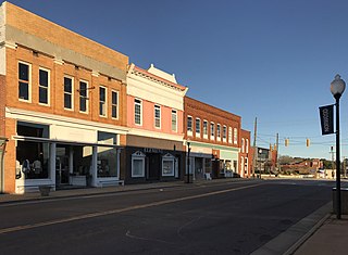
Jonesville, originally called Allen's Settlement, is the oldest town in Yadkin County, North Carolina, United States. The population was 2,285 at the 2010 census. The town grew by nearly 800 residents in 2001 when it merged with neighboring Arlington. Recognized as the Heart of the Yadkin Valley, Jonesville is a gateway to the Blue Ridge Mountains, the Yadkin Valley Heritage/Cultural Corridor and to local wineries in the Swan Creek AVA and the larger Yadkin Valley AVA, as well as offering access to the Yadkin river.

<span class="mw-page-title-main">Yadkinville, North Carolina</span> Town in North Carolina, United States

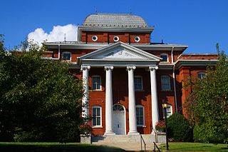
Yadkinville is a town in Yadkin County, North Carolina, United States. The population was 2,995 at the 2020 census. Located in the Piedmont Triad, it is the county seat and largest city of Yadkin County.

<span class="mw-page-title-main">Tobaccoville, North Carolina</span> Village in North Carolina, United States

Tobaccoville is a village in Forsyth and Stokes counties in the U.S. state of North Carolina. The population was 2,209 at the 2020 census. While a Tobaccoville post office was established in 1887, the village was not incorporated until 1991, as a defense against forced annexation of the area by the nearby city of King.

Hamptonville is an unincorporated community located in southwestern Yadkin County, North Carolina, United States. Hamptonville is named for Henry Hampton (1750–1832), a colonel in the Revolutionary Army. Hampton set aside land for a town in 1806.

The Yadkin Ripple is a weekly newspaper based in Yadkinville, North Carolina. It was first published in East Bend, North Carolina, on October 18, 1892.

Courtney is an unincorporated community in southeastern Yadkin County, North Carolina, United States.

Smithtown is an unincorporated community and census-designated place (CDP) in northern Yadkin County, North Carolina, United States. It was first listed as a CDP in the 2020 census with a population of 224.

<span class="mw-page-title-main">Enon, North Carolina</span> Unincorporated community in North Carolina, United States

Enon is an unincorporated community in eastern Yadkin County, North Carolina, United States. The community, which is centered on Enon Baptist Church, is in the Forbush Township and in the East Bend ZIP code zone (27018). It is a Piedmont Triad community.

Forbush is an unincorporated community in central Yadkin County, North Carolina, United States. The community is named for George Forbush, one of the earliest European settlers in Northwestern North Carolina. Forbush, who moved south from Maryland, Pennsylvania and Virginia, settled on the west bank of the Yadkin River about two miles north of Shallow Ford in 1748.

References

  1. "ArcGIS REST Services Directory". United States Census Bureau. Retrieved September 20, 2022.
  2. 1 2 U.S. Geological Survey Geographic Names Information System: East Bend, North Carolina
  3. 1 2 "U.S. Census website". United States Census Bureau . Retrieved January 31, 2008.
  4. "Explore Census Data". data.census.gov. Retrieved June 14, 2022.
  5. "Census of Population and Housing". Census.gov. Retrieved June 4, 2015.
  6. North Carolina Office of State Archaeology
  7. An Illustrated History of Yadkin County, 1850-1980, by W.E. Rutledge Jr., Page 11
  8. Winston-Salem Journal article, Sept. 16, 1996
  9. An Illustrated History of Yadkin County, 1850-1980 by W.E. Rutledge Jr., Page 31
  10. An Illustrated History of Yadkin County, 1850-1980, by W.E. Rutledge Jr., Page 32
  11. "No Regrets," Winston-Salem Journal, September 16, 1996
  12. An Illustrated History of Yadkin County, 1850-1980, by W.E. Rutledge Jr., Page 36
  13. An Illustrated History of Yadkin County, 1850-1980, By W.E. Rutledge Jr., Page 69
  14. Families inspire couple's dream," Winston-Salem Journal, July 31, 2006
  15. "National Register Information System". National Register of Historic Places . National Park Service. July 9, 2010.