Banari is a comune (municipality) in the Province of Sassari in the Italian region Sardinia, located about 150 kilometres (93 mi) north of Cagliari and about 20 kilometres (12 mi) southeast of Sassari.
Burgos is a comune (municipality) in the Province of Sassari in the Italian region Sardinia, located about 130 kilometres (81 mi) north of Cagliari and about 50 kilometres (31 mi) southeast of Sassari. As of 31 December 2004, it had a population of 1,023 and an area of 18.3 square kilometres (7.1 sq mi).

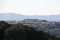
Chiaramonti is a comune (municipality) in the Province of Sassari in the Italian region Sardinia, located about 170 kilometres (110 mi) north of Cagliari and about 25 kilometres (16 mi) east of Sassari. It is part of the Anglona historical regione.
Esporlatu is a comune (municipality) in the Province of Sassari in the Italian region Sardinia, located about 130 kilometres (81 mi) north of Cagliari and about 50 kilometres (31 mi) southeast of Sassari.

Giave is a comune (municipality) in the Province of Sassari in the Italian region Sardinia, located about 140 kilometres (87 mi) north of Cagliari and about 35 kilometres (22 mi) southeast of Sassari. As of 31 December 2004, it had a population of 655 and an area of 47.1 square kilometres (18.2 sq mi).
Martis is a comune (municipality) in the Province of Sassari in the Italian region Sardinia, about 180 kilometres (110 mi) north of Cagliari and about 25 kilometres (16 mi) east of Sassari. As of 31 December 2004, it had a population of 608 and an area of 22.9 square kilometres (8.8 sq mi). It borders the municipalities of Chiaramonti, Laerru, Nulvi, Perfugas.

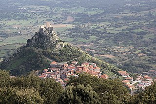
Monteleone Rocca Doria is a comune (municipality) in the Province of Sassari in the Italian region Sardinia, located about 150 kilometres (93 mi) northwest of Cagliari and about 30 kilometres (19 mi) south of Sassari. As of 2018, it had a population of 99 and an area of 13.0 square kilometres (5.0 sq mi).

Muros is a comune (municipality) in the Province of Sassari in the Italian region Sardinia, located about 170 kilometres (110 mi) north of Cagliari and about 8 kilometres (5 mi) southeast of Sassari. As of 31 December 2004, it had a population of 760 and an area of 11.2 square kilometres (4.3 sq mi).

Olmedo is a comune (municipality) in the Province of Sassari in the Italian region of Sardinia, located about 170 kilometres (110 mi) northwest of Cagliari and about 15 kilometres (9 mi) southwest of Sassari. As of 31 December 2004, it had a population of 3,041 and an area of 33.7 square kilometres (13.0 sq mi).

Osilo is a comune (municipality) in the Province of Sassari in the Italian region Sardinia, located about 170 kilometres (110 mi) north of Cagliari and about 10 kilometres (6 mi) east of Sassari. It is part of the Anglona traditional region. The municipality of Osilo contains the frazioni Santa Vittoria and San Lorenzo.

Padria is a comune (municipality) in the Province of Sassari on the Italian island of Sardinia, located about 140 kilometres (87 mi) northwest of Cagliari and about 40 kilometres (25 mi) south of Sassari. As of 31 December 2004, it had a population of 785 and an area of 48.0 square kilometres (18.5 sq mi).
Perfugas is a comune (municipality) in the Province of Sassari in the Italian region Sardinia, located about 180 kilometres (110 mi) north of Cagliari and about 30 kilometres (19 mi) northeast of Sassari.

Pozzomaggiore is a comune (municipality) in the Province of Sassari in the Italian region Sardinia, located about 140 kilometres (87 mi) northwest of Cagliari and about 40 kilometres (25 mi) south of Sassari. As of 31 December 2004, it had a population of 2,871 and an area of 79.4 square kilometres (30.7 sq mi).

Romana is a comune (municipality) in the Province of Sassari in the Italian region Sardinia, located about 150 kilometres (93 mi) northwest of Cagliari and about 30 kilometres (19 mi) south of Sassari. As of 31 December 2004, it had a population of 608 and an area of 21.6 square kilometres (8.3 sq mi).

Semestene is a comune (municipality) in the Province of Sassari in the Italian region Sardinia, located about 140 kilometres (87 mi) north of Cagliari and about 40 kilometres (25 mi) southeast of Sassari. As of 31 December 2004, it had a population of 206 and an area of 39.8 square kilometres (15.4 sq mi).

Sennori is a comune (municipality) in the Province of Sassari in the Italian region Sardinia, located about 180 kilometres (110 mi) north of Cagliari and about 7 kilometres (4 mi) northeast of Sassari. As of 31 December 2004, it had a population of 7,298 and an area of 31.4 square kilometres (12.1 sq mi).
Tissi is a comune (municipality) in the Province of Sassari in the Italian region Sardinia, located about 170 kilometres (110 mi) northwest of Cagliari and about 6 kilometres (4 mi) south of Sassari. As of 31 December 2004, it had a population of 2,017 and an area of 10.3 square kilometres (4.0 sq mi).

Tula is a comune (municipality) in the Province of Sassari in the Italian region Sardinia, located about 170 kilometres (110 mi) north of Cagliari and about 35 kilometres (22 mi) east of Sassari. As of 31 December 2004, it had a population of 1,664 and an area of 65.6 square kilometres (25.3 sq mi).

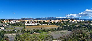
Uri is a comune (municipality) in the Province of Sassari in the Italian region Sardinia, located about 18 kilometres (11 mi) from Alghero (airport) and about 12 kilometres (7 mi) northwest of Sassari and about 170 kilometres (110 mi) from Cagliari (airport). It is known for its artichoke festival, held annually in March. As of 31 December 2004, it had a population of 3,040 and an area of 56.7 square kilometres (21.9 sq mi).

Villanova Monteleone is a comune (municipality) in the Province of Sassari in the Italian region Sardinia, located about 150 kilometres (93 mi) northwest of Cagliari and about 25 kilometres (16 mi) southwest of Sassari. As of 31 December 2004, it had a population of 2,528 and an area of 202.2 square kilometres (78.1 sq mi).