Examples of refugia

Last updated

The northern and southern hemispheres of the earth have a dynamic history of advancing and retreating ice sheets. The glacial and interglacial periods are linked to regular eccentricities in the Earth's orbit and correspond to approximately 100 kyr cycles. The advancing, or glacial periods can cause a massive displacement of flora and fauna as it drives them away from the poles, with the most recent glacial maximum having occurred about 20,000 years ago., [1] [2]

Contents

Refugia

While most of the biota were driven away from the poles during the glacial advance, there were still isolated areas of sanctuary. These locations are referred to as refugia. A refugium is defined by Ceridwen et al. as a “geographical area in which populations of glacially impacted organisms persisted during the LGM (Last Glacial Maximum).” Some different types of these areas are coastal, embedded, and periglacial refugia. Coastal refugia are locations of refuge located on uncovered coastal regions or islands. Due to a lower sea level during the last glacial period, it is suspected that the exposed continental shelf played a large role in acting as a refugium to many different organisms as well as potential route for migration. [3] Periglacial refers to refugia located adjacent to a glacier or an ice sheet. Embedded refugia are areas that remained uncovered within the limit of the glacial advance (hot springs or nunataks). [2]

Effects of ice age on Northern and Southern Hemispheres

In the northern hemisphere, the last glacial maximum reached about 40˚ N in North America, covering the Great Lakes. In Scandinavia, it extended down to about 52˚ N, affecting parts of Britain and the northern regions of Europe. [1] The majority of the ice coverage was over land, allowing for major retreat during glacial periods. [2] There are some areas on the west coast of Alaska and British Columbia that are projected as coastal refugia for organisms. There is also a potential refugium in the far north of Scandinavia on the island of Andøya.

In the southern hemisphere, the majority of the ice coverage was over the ocean with some glaciation present on South America and New Zealand. While this glaciation wasn't as extensive as that of the northern latitudes, the climate was still affected. [1] As a result of the glacial advance, biota retreated north to warmer regions and east over the Andes to avoid the Patagonian ice sheet. Also, many mobile marine fauna migrated north to some of the surrounding islands, out of reach of the oceanic ice sheet. [2] In addition to periglacial and coastal refugia, there were also possible areas of embedded refugia in Patagonia and New Zealand.

Southern Hemisphere

South America

As the LGM ice sheet crept along the west coast of South America, it drove the previous inhabitants north and east. The northern traveling flora and fauna established in the warmer, coastal regions of Chile, out of reach of the ice that stretched up to 40˚ S latitude. Those that moved east jumped the Andes and established themselves in periglacial refugia on the eastern slopes, or further down in the more low-lying areas of Argentina that remained unaffected by the ice retreat. Additionally, there were areas of embedded refugia that may have allowed for habitation by freshwater crabs, fish, and even otters. [2]

The freshwater crabs (Aegla alacalufi) were suspected to have survived in hot springs, which may have kept the ice from forming in that area. [2] The fish, Galaxias platei, were thought to have survived not only in eastern refugia over the Andes, but also in isolated proglacial lakes in the northernmost portions of Patagonia. This was inferred by the genetic lineages suggesting a larger group to the east of the Andes and smaller more isolated groups to the west of the Andes during the LGM. [4]

As good food sources for the Patagonian otter ( Lontra provocax ), the Galaxias platei and the Aegla alacalufi may have played a part in sustaining this aquatic mammal during this glacial period. Today, this otter is found throughout Southern Argentina and Chile and is found as far north as 39˚S. During the LGM, most of its habitat was covered by ice. DNA testing of L. provocax in the Patagonian area has shown potential embedded refugia in the southern coastal region, with intertidal crustaceans in addition to other embedded aquatic life as possible food sources. [5]

New Zealand

Evidence of a possible refugium for forest habitat was found in the northern, glacially-affected Howard Valley, situated on the South Island of New Zealand. This location consists of high peaks and deep U-shaped valleys. Today it is characterized by grassland valley floor and forested slopes. Glacial advances in this area occurred around 28000, 21500, and 19000 years BP (before present). [6]

The deep valleys found in this location may have acted as microclimates that sheltered the trees from glacial conditions and climate. Pollen studies show that these valleys consisted mostly of grasses and shrubs around 25,000–22,000 years BP. A low occurrence of beech ( Nothofagus menziesii ) pollen (dated to 25,742–22,988 years BP) suggests a refugium in this area. Another line of evidence was found in the fossilized remains of ground beetles dating back to 25,742–22,988 years BP. Because these beetles are normally associated with tree line habitats, their location suggests an altitudinal tree limit during the glacial period. Based on these lines of evidence, beech forest may have been more common in lower elevation areas of the Howard Valley during periods of glacial advance. [6]

Sub-Antarctic island refugia

The many islands surrounding Antarctica may have played large roles in the survival of marine life during the LGM. With the extent of the ice sheet from the coasts of the Antarctic continent, only the most mobile of fauna were able to retreat north.

In the case of petrels and other flying seabirds, the ability to nest on nunataks may have allowed them the ability to stay on the continent during the glacial period and fly down to the edge of the ice for food. [2] However, this was most likely not the case with colony forming species such as the Adélie penguin and the Antarctic elephant seal.

The Antarctic elephant seal was likely a resident of the Antarctic continent (Victoria Land) 7,500–8,000 years ago. However, an advance of ice 1000 years ago drove them away to the more northern Macquarie Island. [2] With evidence of such a large migration route, Macquarie and other similar islands likely acted as refugia for elephant seals as well as other marine life during the LGM as they moved to areas unaffected by the ice.

An example of this is the Adélie penguin, which is widespread on the islands surrounding Antarctica. Genetic evidence suggests that the modern Adélie penguin has stemmed from two different lineages. This postulates two island refugia during the LGM. [2]

Northern Hemisphere

Alexander Archipelago

The islands of the Alexander Archipelago make up a large part of Alaska's panhandle. It is host to over 2000 islands, some with mountains exceeding 1000 meters in elevation. These higher peaks still support remnants of the ice age: snowfields and small glaciers. During the glacial period, glacier formation was accompanied by a lowering in the sea level, which likely helped expose the now submerged continental shelf. While the majority of the Archipelago was covered in ice, these outer coast areas where continental shelf was exposed were very likely coastal refugia for a variety of plants and animals. Examples of these spots include Baranof Island, which has a lack of glacial evidence on its southern end, suggesting lack of coverage during the LGM. Also, Coronation Island seems to have relatively minor glaciation. In support of possible refugia, a brown bear skeleton was found on Coronation dating back to 11630 years BP. This may show that there was a refugium nearby that this bear could have traveled from. It may also indicate that Coronation was a refugium that provided a food source for the bear. [3]

On both of the outer islands, Baranof and Coronation, there are high levels of endemic mammalian species. This is true of Chichagof, Forrester, and Warren islands as well; all three of which help make up the furthest extent of the Alexander Archipelago. These regions of endemism have been interpreted as possible coastal refugia. [3]

An example of this endemism is found when looking at brown bears in the Alexander Archipelago. These bears exhibit a lower genetic diversity than bears found inland. Additionally, genetic tests have shown them to be more closely related to present-day polar bears than mainland bears. This evidence suggests that they may have inhabited the Archipelago for at least 40,000 years, with habitable refugia existent throughout this time. [3]

Another species that might have made use of refugia during this time is the Chum salmon. It appears that the different groups of salmon that spawn on the Prince of Wales Island are more similar to one another than they are to salmon elsewhere in SE Alaska. This has been interpreted as meaning that Prince of Wales Island is the source of present-day Chum salmon, whose Wisconsin Glaciation may have been spent living in streams on the exposed continental shelf. [3]

There has also been possible evidence of flora in refugia. Analysis of pollen deposits on Pleasant Island, near Glacier Bay, dates the arrival of shore pine and mountain hemlock to about 11900 years ago. Because of the early arrival to the area, and also shared genetic information found almost exclusively in trees of this region, it is suggested that nearby coastal refugia were the source of this pollen. [3]

The exposed continental shelf during the LGM seems to have played a big part in supplying glacier refugia. That being said, the extent of the exposure is not well known. The evidence needed to show the composition and scope of these once exposed shelves is now deep underwater. A lack of information is due in part to the remoteness of the outer coast in addition to a lack of sea-floor imagery. [3]

Queen Charlotte Islands

A study of endemic ground-beetle population on the Queen Charlotte Islands has given possible evidence for refugia in this region. The ground-beetle, or Carabid beetle, is an insect found worldwide. These beetles are oftentimes conspicuous and abundant, making them easy to collect, prepare, and study. The majority of carabids are found in cool- to cold-temperate zones, and almost half of its 20,000 identified species have been found in Canada and Alaska alone. [7]

There were three identified endemic species of carabid beetle found on the Queen Charlotte Islands. All three of these species were found to exhibit brachyptery, which is the reduction of the beetles’ wings. Brachyptery was found to occur in areas of long-term occupation such as refugia, where wing-reduction allowed for the redirection of energy for travel towards other uses such as reproduction. Another finding was that between these three endemic species, they had two preferred habitats: high alpine zones and rocky beaches. These three species would have been well suited to refugia during the LGM as the continental shelf was exposed and some mountain peaks stuck out from the top of the ice sheet. [7]

Cypress Hills

The Cypress Hills in Southeastern Alberta and Southwestern Saskatchewan, are a collection of hills that rise above the surrounding prairies. During the Laurentide Glaciation the Cypress Hills were left ice free. [8] The Cypress Hills Glacial Refugia was home a diversity of flora and fauna.

Europe

During the LGM, many of the species of Europe retreated south, out of reach of the ice sheet and the colder climate. These southern refugia have been shown in looking at the pathways of the common European meadow grasshopper. Through analysis of the grasshoppers’ genome it was found that they had been divided into 5 different geographical regions: Turkey, Greece, Italy, Spain, and the Balkans. [9] Despite significant differences in the ecology of species, some general colonization patterns are observed which are often common to several species groups. [10] These colonization entailed successive bottlenecks phenomena that led to a loss of genetic diversity in northern populations. [11] Therefore, based on the data of numerous phylogeographic research, the high genetic diversity of populations of southern regions can often be an indication for positioning a Pleistocene refugium, while the geographical distributions of the northern populations are dictated by the colonization patterns of the refugia populations. [12] While these southern refugia have been found for many other species of flora and fauna, there may have been high altitude refugia on the coast of northern Norway.

One proposed refugium is on the island of Andøya in Norway. Pollen and chloroplast DNA of spruce and pine, found in the sedimentary deposits on this island, were dated to about 22,000 years BP for the spruce and about 17,700 years BP for the pine. [13] This would put the pine in this region at a time when the ice sheet was just beginning to retreat, and would place the spruce in the area shortly after. When comparing this information to the geographical and climatic history of this region, the data seems questionable.

As the ice retreated about 22,000 years ago, it resulted in the submergence of large parts of the coastline in water. The study site in Andøya was underwater until about 18,000 years BP, making habitation of spruce unlikely. Furthermore, this regions present climate does not support spruce and is not ideal for pine. Because this region was likely harsher during the glacial period, it is doubtful that an already ill-equipped species would have been able to establish let alone survive. A possible explanation for the debatable dates obtained from the pollen and chloroplast samples is measurement device contamination. [14]

Related Research Articles

<span class="mw-page-title-main">Pleistocene</span> First epoch of the Quaternary Period

The Pleistocene is the geological epoch that lasted from c. 2.58 million to 11,700 years ago, spanning the Earth's most recent period of repeated glaciations. Before a change was finally confirmed in 2009 by the International Union of Geological Sciences, the cutoff of the Pleistocene and the preceding Pliocene was regarded as being 1.806 million years Before Present (BP). Publications from earlier years may use either definition of the period. The end of the Pleistocene corresponds with the end of the last glacial period and also with the end of the Paleolithic age used in archaeology. The name is a combination of Ancient Greek πλεῖστος (pleîstos), meaning "most", and καινός, meaning "new".

<span class="mw-page-title-main">Wisconsin glaciation</span> North American glacial ice sheet

The Wisconsin Glacial Episode, also called the Wisconsin glaciation, was the most recent glacial period of the North American ice sheet complex. This advance included the Cordilleran Ice Sheet, which nucleated in the northern North American Cordillera; the Innuitian ice sheet, which extended across the Canadian Arctic Archipelago; the Greenland ice sheet; and the massive Laurentide Ice Sheet, which covered the high latitudes of central and eastern North America. This advance was synchronous with global glaciation during the last glacial period, including the North American alpine glacier advance, known as the Pinedale glaciation. The Wisconsin glaciation extended from approximately 75,000 to 11,000 years ago, between the Sangamonian Stage and the current interglacial, the Holocene. The maximum ice extent occurred approximately 25,000–21,000 years ago during the last glacial maximum, also known as the Late Wisconsin in North America.

<span class="mw-page-title-main">Last Glacial Period</span> Period of major glaciations of the northern hemisphere (115,000–12,000 years ago)

The Last Glacial Period (LGP), also known colloquially as the Last Ice Age or simply Ice Age, occurred from the end of the Eemian to the end of the Younger Dryas, encompassing the period c. 115,000 – c. 11,700 years ago.

<span class="mw-page-title-main">Antarctic Peninsula</span> Peninsula located in northern Antarctica

The Antarctic Peninsula, known as O'Higgins Land in Chile and Tierra de San Martín in Argentina, and originally as Graham Land in the United Kingdom and the Palmer Peninsula in the United States, is the northernmost part of mainland Antarctica.

<span class="mw-page-title-main">Last Glacial Maximum</span> Most recent time during the Last Glacial Period that ice sheets were at their greatest extent

The Last Glacial Maximum (LGM), also referred to as the Last Glacial Coldest Period, was the most recent time during the Last Glacial Period that ice sheets were at their greatest extent 26,000 and 20,000 years ago. Ice sheets covered much of Northern North America, Northern Europe, and Asia and profoundly affected Earth's climate by causing a major expansion of deserts, along with a large drop in sea levels.

<span class="mw-page-title-main">Cordilleran ice sheet</span> Major ice sheet that periodically covered large parts of North America during glacial periods

The Cordilleran ice sheet was a major ice sheet that periodically covered large parts of North America during glacial periods over the last ~2.6 million years.

<span class="mw-page-title-main">Refugium (population biology)</span>

In biology, a refugium is a location which supports an isolated or relict population of a once more widespread species. This isolation (allopatry) can be due to climatic changes, geography, or human activities such as deforestation and overhunting.
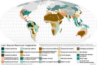
<span class="mw-page-title-main">Oldest Dryas</span> Abrupt climatic cooling event during the last glacial retreat

The Oldest Dryas is a biostratigraphic subdivision layer corresponding to a relatively abrupt climatic cooling event, or stadial, which occurred during the last glacial retreat. The time period to which the layer corresponds is poorly defined and varies between regions, but it is generally dated as starting at 18.5–17 thousand years (ka) before present (BP) and ending 15–14 ka BP. As with the Younger and Older Dryas events, the stratigraphic layer is marked by abundance of the pollen and other remains of Dryas octopetala, an indicator species that colonizes arctic-alpine regions. The termination of the Oldest Dryas is marked by an abrupt oxygen isotope excursion, which has been observed at many sites in the Alps that correspond to this interval of time.
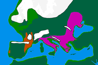
The Late Glacial Interstadial (LGI) c. 14,670 to c. 12,890 BP, also called the Bølling–Allerød interstadial, represents the first pronounced warming since the end of the Last Glacial Maximum (LGM). Human populations, which had previously been forced into refuge areas, gradually begin to repopulate the Northern Hemisphere's Eurasian landmass.

<span class="mw-page-title-main">Irish Sea Glacier</span> Huge glacier during the Pleistocene Ice Age

The Irish Sea Glacier was a huge glacier during the Pleistocene Ice Age that, probably on more than one occasion, flowed southwards from its source areas in Scotland and Ireland and across the Isle of Man, Anglesey and Pembrokeshire. It probably reached its maximum extent during the Anglian Glaciation, and it was also extensive during the Late Devensian Glaciation.

<span class="mw-page-title-main">Weichselian glaciation</span> Last glacial period and its associated glaciation in northern parts of Europe

The Weichselian glaciation was the last glacial period and its associated glaciation in northern parts of Europe. In the Alpine region it corresponds to the Würm glaciation. It was characterized by a large ice sheet that spread out from the Scandinavian Mountains and extended as far as the east coast of Schleswig-Holstein, northern Poland and Northwest Russia. This glaciation is also known as the Weichselian ice age, Vistulian glaciation, Weichsel or, less commonly, the Weichsel glaciation, Weichselian cold period (Weichsel-Kaltzeit), Weichselian glacial (Weichsel-Glazial), Weichselian Stage or, rarely, the Weichselian complex (Weichsel-Komplex).

<span class="mw-page-title-main">Biodiversity of Borneo</span>

The island of Borneo is located on the Sunda Shelf, which is an extensive region in Southeast Asia of immense importance in terms of biodiversity, biogeography and phylogeography of fauna and flora that had attracted Alfred Russel Wallace and other biologists from all over the world.

<span class="mw-page-title-main">ABC Islands bear</span> Subspecies of brown bear found in Southeast Alaska

The ABC Islands bear or Sitka brown bear is a subspecies or population of brown bear that resides in Southeast Alaska and is found on Admiralty Island, Baranof Island, and Chichagof Island in Alaska, and a part of the Alexander Archipelago. It has a unique genetic structure that relates them not only to brown bears, but also to polar bears. Its habitat exists within the Tongass National Forest, which is part of the perhumid rainforest zone.

A glacial refugium is a geographic region which made possible the survival of flora and fauna during ice ages and allowed for post-glacial re-colonization. Different types of glacial refugia can be distinguished, namely nunatak, peripheral, and lowland. Glacial refugia have been suggested as a major cause of floral and faunal distribution patterns in both temperate and tropical latitudes. With respect to disjunct populations of modern-day species, especially in birds, doubt has been cast on the validity of such inferences, as much of the differentiation between populations observed today may have occurred before or after their restriction to refugia. In contrast, isolated geographic locales that host one or more critically endangered species are generally uncontested as bona fide glacial refugia.

<span class="mw-page-title-main">Vashon Glaciation</span>

The Vashon Glaciation, Vashon Stadial or Vashon Stade is a local term for the most recent period of very cold climate in which during its peak, glaciers covered the entire Salish Sea as well as present day Seattle, Tacoma, Olympia and other surrounding areas in the western part of present-day Washington (state) of the United States of America. This occurred during a cold period around the world known as the last glacial period. This was the most recent cold period of the Quaternary glaciation, the time period in which the arctic ice sheets have existed. The Quaternary Glaciation is part of the Late Cenozoic Ice Age, which began 33.9 million years ago and is ongoing. It is the time period in which the Antarctic ice cap has existed.

<span class="mw-page-title-main">Llanquihue glaciation</span> Last glacial period in southern Chile

The last glacial period and its associated glaciation is known in southern Chile as the Llanquihue glaciation. Its type area lies west of Llanquihue Lake where various drifts or end moraine systems belonging to the last glacial period have been identified. The glaciation is the last episode of existence of the Patagonian Ice Sheet. Around Nahuel Huapi Lake the equivalent glaciation is known as the Nahuel Huapi Drift.

<span class="mw-page-title-main">Glacial survival hypothesis</span>

According to the northern cryptic glacial refugial hypothesis, during the last ice age cold tolerant plant and animal species persisted in ice-free microrefugia north of the Alps in Europe. The alternative hypothesis of no persistence and postglacial immigration of plants and animals from southern refugia in Europe is sometimes also called the tabula rasa hypothesis.

<span class="mw-page-title-main">Peopling of the Americas</span> Prehistoric migration from Asia to the Americas

The peopling of the Americas began when Paleolithic hunter-gatherers (Paleo-Indians) entered North America from the North Asian Mammoth steppe via the Beringia land bridge, which had formed between northeastern Siberia and western Alaska due to the lowering of sea level during the Last Glacial Maximum. These populations expanded south of the Laurentide Ice Sheet and spread rapidly southward, occupying both North and South America, by 12,000 to 14,000 years ago. The earliest populations in the Americas, before roughly 10,000 years ago, are known as Paleo-Indians. Indigenous peoples of the Americas have been linked to Siberian populations by linguistic factors, the distribution of blood types, and in genetic composition as reflected by molecular data, such as DNA.

The coastal migration hypothesis is one of two leading hypotheses about the settlement of the Americas at the time of the Last Glacial Maximum. It proposes one or more migration routes involving watercraft, via the Kurile island chain, along the coast of Beringia and the archipelagos off the Alaskan-British Columbian coast, continuing down the coast to Central and South America. The alternative is the hypothesis solely by interior routes, which assumes migration along an ice-free corridor between the Laurentide and Cordilleran ice sheets during the Last Glacial Maximum.

<span class="mw-page-title-main">Penultimate Glacial Period</span> Glacial age that occurred before the Last Glacial Period

The Penultimate Glacial Period (PGP) is the glacial age that occurred before the Last Glacial Period. The penultimate glacial period is officially unnamed just like the Last Glacial Period. While the PGP is a part of the ongoing Quaternary ice age, which began 2.58 million years ago, the PGP lasted from ~194,000 years ago, to ~135,000 years ago. The PGP also occurred during the Marine Isotope age 6 (MIS6). At the glacial ages’ height, it is known to be the most extensive expansion of glaciers in the last 400,000 years over Eurasia, and could be the second or third coolest glacial period over the last 1,000,000 years, as shown by ice cores. Due to this, the global sea level dropped to between 92 and 150 metres below modern-day global mean sea level. The penultimate glacial period expanded ice sheets and shifted temperature zones worldwide, which had a variety of effects on the world's environment, and the organisms that lived in it. At its height, the penultimate glacial period was a more severe glaciation than the Last Glacial Maximum. The PGP is an unofficial name for the last period of the Saalian glaciation, called the Wolstonian Stage in Britain.

References

  1. 1 2 3 Hewitt, Godfrey M. “Some genetic consequences of ice ages, and their role in divergence and speciation.” Biological Journal of the Linnean society. No. 58, 1996. (247-276)
  2. 1 2 3 4 5 6 7 8 9 Ceridwen et al. “Poleward Bound: biological impacts of southern Hemisphere glaciation.” Trends in Ecology and Evolution. Vol. 27, No. 8, August 2012. (462-471)
  3. 1 2 3 4 5 6 7 Carrara, P.E., et al. “Possible refugia in the Alexander Archipelago of southeastern Alaska during the late Wisconsin glaciation.” Can. J. Earth Sci. 44: 229-244 (2007)
  4. Zemlak, T.S. et al. “Across the Southern Andes on fin: glacial refugia, drainage reversals and a secondary contact zone revealed by the phylogeographical signal of Galaxias platei in Patagonia. Mol. Ecol. 17, 5049-5061.
  5. Vianna,J. A., et al. “Phylogeography of the Patagonian otter Lontra provocax: adaptive divergence to marine habitat or signature of southern glacial refugia? BMC Evol. Biol. 11, 53
  6. 1 2 Marra, Maureen J., et al. “Glacial forest refugium in Howard Valley, South Island, New Zealand.” Journal of Quaternary Science (2010) 25(3). (309-319)
  7. 1 2 Kavanaugh, David H. “The Ground-Beetle (Coleoptera: Carabidae) fauna of the Queen Charlotte Islands. Its composition, affinities, and origins.” The Outer Shores. 1984 (131-146)
  8. "Nature & History - Cypress Hills Provincial Park | Alberta Parks". www.albertaparks.ca. Retrieved 2023-06-06.
  9. Hewit, Godfrey. “The genetic legacy of the Quaternary ice ages.” Nature, vol. 405, 22 June 2000. (907-913)
  10. Hewitt, Godfrey. "Post‐glacial re‐colonization of European biota." Biological journal of the Linnean Society, 68, 87-112, 1999
  11. Bennett, K. et al. "Quaternary refugia of north European trees." Journal of Biogeography, 18, 103-115, 1991
  12. Taberlet, P. et al. "Comparative phylogeography and postglacial colonization routes in Europe." Molecular Ecology, 7, 453–464, 1998
  13. Parducci, Laura, et al. “Glacial Survival of Boreal Trees in Northern Scandinavia.” Science, vol. 335, no. 6072. 2 March 2012. (1083-1086)
  14. Birks, Hilary H., et al. “Comment on ‘Glacial survival of boreal trees in Northern Scandinavia.’” Science, vol. 338, no. 6108. 9 November 2012. (742)