Extreme points of the Arctic

Last updated

This is a list of the extreme points of the Arctic , the points of Arctic lands that are farther to the north than any other location classified by continent and country, latitude and longitude, and distance to the North Pole. The list is sorted from north to south.

Contents

NameCountryRegionCoordinatesDistance from PoleNorthernmost land of
kmmi
Kaffeklubben Island, Peary Land Denmark (Greenland) North America 83°40′N29°50′W / 83.667°N 29.833°W / 83.667; -29.833 (Kaffeklubben Island) 707439Earth
Cape Morris Jesup, Peary LandDenmark (Greenland)North America 83°37′39″N32°39′52″W / 83.62750°N 32.66444°W / 83.62750; -32.66444 (Cape Morris Jesup) 712442Greenlandic mainland
Cape Columbia, Ellesmere Island, Nunavut Canada North America 83°06′41″N69°57′12″W / 83.11139°N 69.95333°W / 83.11139; -69.95333 (Cape Columbia) 769478Canada
Cape Fligely, Rudolf Island, Franz Josef Land, Arkhangelsk Oblast Russia Europe 81°50′35″N59°14′22″E / 81.84306°N 59.23944°E / 81.84306; 59.23944 (Cape Fligely) 911566 Eurasia, including Europe
Arctic Cape, Komsomolets Island, Severnaya Zemlya, Krasnoyarsk Krai RussiaAsia 81°13′N95°15′E / 81.217°N 95.250°E / 81.217; 95.250 (Arctic Cape) 981610Asia
Rossøya, Sjuøyane, Svalbard archipelago Norway Europe 80°49′45″N20°24′0″E / 80.82917°N 20.40000°E / 80.82917; 20.40000 (Rossøya) 1,024636 Western Europe
Cape Chelyuskin, Taymyr Peninsula, Krasnoyarsk KraiRussia Asia 77°44′N104°15′E / 77.733°N 104.250°E / 77.733; 104.250 (Cape Chelyuskin) 1,370850any mainland continent
Murchison Promontory, Boothia Peninsula, NunavutCanadaNorth America 71°59′55″N94°32′45″W / 71.99861°N 94.54583°W / 71.99861; -94.54583 (Murchison Promontory) 2,0141,251mainland North America
Point Barrow, Alaska United States North America 71°23′20″N156°28′45″W / 71.38889°N 156.47917°W / 71.38889; -156.47917 (Point Barrow) 2,0781,291United States
Cape Nordkinn, Gamvik Municipality, Finnmark NorwayEurope 71°08′02″N27°39′00″E / 71.13389°N 27.65000°E / 71.13389; 27.65000 (Cape Nordkinn) 2,1061,309mainland Continental Europe
Nuorgam, Lapland Finland Europe 70°05′18″N27°56′30″E / 70.08833°N 27.94167°E / 70.08833; 27.94167 2,2001,400Finland
Three-Country Cairn, Lapland Sweden Europe 69°03′35.9″N20°32′55.1″E / 69.059972°N 20.548639°E / 69.059972; 20.548639 2,3251,445Sweden
Grímsey island, Eyjafjörður Iceland Europe 66°33′N18°01′W / 66.550°N 18.017°W / 66.550; -18.017 2,6051,619Iceland

Highest point

Lowest point

See also

Notes

  1. Gunnbjørn Fjeld is the highest point on the Island of Greenland, Kalaallit Nunaat, the Kingdom of Denmark, and the entire Arctic.

Related Research Articles

<span class="mw-page-title-main">Geography of Greenland</span>

Greenland is located between the Arctic Ocean and the North Atlantic Ocean, northeast of Canada and northwest of Iceland. The territory comprises the island of Greenland—the largest island in the world—and more than a hundred other smaller islands. Greenland has a 1.2-kilometer-long (0.75 mi) border with Canada on Hans Island. A sparse population is confined to small settlements along certain sectors of the coast. Greenland possesses the world's second-largest ice sheet.

<span class="mw-page-title-main">Gunnbjørn Fjeld</span> Tallest mountain in Greenland

Gunnbjørn Fjeld is the tallest mountain in Greenland, Denmark, and north of the Arctic Circle. It is a nunatak, a rocky peak protruding through glacial ice.

<span class="mw-page-title-main">Extreme points of North America</span> Most prominent locations of the continents physical boundaries

This is a list of the extreme points of North America: the points that are highest and lowest, and farther north, south, east or west than any other location on the continent. Some of these points are debatable, given the varying definitions of North America.

This is a list of the extreme points of The Americas, the points that are farther north, south, east or west than any other location on the continent. The continent's southernmost point is often said to be Cape Horn, which is the southernmost point of the Chilean islands. The Americas cross 134° of longitude east to west and 124° of latitude north to south.
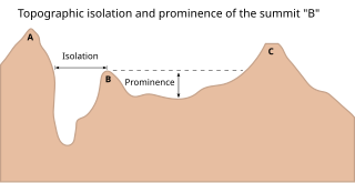
<span class="mw-page-title-main">Topographic isolation</span> Topography measuring minimum distance to a point of equal elevation

The topographic isolation of a summit is the minimum distance to a point of equal elevation, representing a radius of dominance in which the peak is the highest point. It can be calculated for small hills and islands as well as for major mountain peaks and can even be calculated for submarine summits. Mount Everest, the highest point on Earth, has an undefined isolation, since there are no higher points to reference.

<span class="mw-page-title-main">Outline of Greenland</span> Overview of and topical guide to Greenland

The following outline is provided as an overview of and topical guide to Greenland:

<span class="mw-page-title-main">Index of Greenland-related articles</span>

The following is an alphabetical list of topics related to the nation of Kalaallit Nunaat (Greenland).
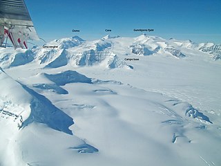
<span class="mw-page-title-main">Watkins Range</span> Mountain range in Greenland

The Watkins Range is Greenland's highest mountain range. It is located in King Christian IX Land, Sermersooq municipality.

References

  1. "Gunnbjørn Fjeld". Summits of the World. peakbagger.com. Retrieved September 8, 2012.