
Acushnet is a town in Bristol County, Massachusetts, United States. The population was 10,559 at the 2020 census.

Fairhaven is a town in Bristol County, Massachusetts, United States. It is located on the South Coast of Massachusetts where the Acushnet River flows into Buzzards Bay, an arm of the Atlantic Ocean. The town shares a harbor with the city of New Bedford, a place well known for its whaling and fishing heritage; consequently, Fairhaven's history, economy, and culture are closely aligned with those of its larger neighbor. The population of Fairhaven was 15,924 at the time of the 2020 census.

New Bedford is a city in Bristol County, Massachusetts, United States. It is located on the Acushnet River in what is known as the South Coast region. Up through the 17th century, the area was the territory of the Wampanoag Native American people. English colonists bought the land on which New Bedford would later be built from the Wampanoag in 1652, and the original colonial settlement that would later become the city was founded by English Quakers in the late 17th century. The town of New Bedford itself was officially incorporated in 1787.
Fairhaven or Fair Haven may refer to:
The Stone Fleet consisted of a fleet of aging ships purchased in New Bedford and other New England ports, loaded with stone, and sailed south during the American Civil War by the Union Navy for use as blockships. They were to be deliberately sunk at the entrance of Charleston Harbor, South Carolina in the hope of obstructing blockade runners, then supplying Confederate interests. Although some sank along the way and others were sunk near Tybee Island, Georgia, to serve as breakwaters, wharves for the landing of Union troops, the majority were divided into two lesser fleets. One fleet was sunk to block the south channel off Morris Island, and the other to block the north channel near Rattlesnake Shoals off the present day Isle of Palms in what proved to be failed efforts to block access the main shipping channels into Charleston Harbor.
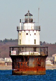
Butler Flats Light is a sparkplug lighthouse located in the outer harbor of New Bedford, Massachusetts, at the mouth of the Acushnet River. Built in 1898 by the United States Lighthouse Board, it is the only known caisson lighthouse designed by a marine architect. The light was added to the National Register of Historic Places as Butler Flats Light Station on June 15, 1987. Automated in 1978, it is now operated by the city as a private aid to navigation.

WFHN, better known as Fun 107, is a Contemporary Hit Radio radio station that serves the New Bedford-Fall River, Massachusetts market along with the Providence, Rhode Island market, broadcasting on the FM band at 107.1 MHz. The station is licensed to Fairhaven, Massachusetts to Townsquare Media. The studio is located in Fairhaven, Massachusetts, shared with WBSM. The transmitter is located in New Bedford, Massachusetts on Pope's Island on a tower shared with W243BG. The station was originally built by broadcast engineer Randy Place in 1988–1989.

The Acushnet River is the largest river, 8.6 miles (13.8 km) long, flowing into Buzzards Bay in southeastern Massachusetts, in the United States. The name "Acushnet" comes from the Wampanoag or Algonquian word, "Cushnea", meaning "as far as the waters", a word that was used by the original owners of the land in describing the extent of the parcel they intended to sell to the English settlers from the nearby Plimouth colony. Quite naturally, the English mistook "Cushnea" for a fixed placename or the name of a specific river.
Route 240 is a 1.3-mile-long (2.1 km) south–north state highway in southeastern Massachusetts. Its southern terminus is at U.S. Route 6 in Fairhaven and its northern terminus is at Interstate 195 (I-195) in Fairhaven.

Prince Henry the Navigator Park on Pope's Island in New Bedford, Massachusetts, is dedicated to Prince Henry the Navigator. It was created in 1994, a gift to the city from the Prince Henry Society of New Bedford and the Portuguese government.

The New Bedford-Fairhaven Bridge is a swing truss bridge which connects New Bedford, Massachusetts with Fairhaven, Massachusetts.

Palmer Island Light Station is a historic lighthouse in New Bedford Harbor in New Bedford, Massachusetts, USA. The lighthouse was built in 1849 out of stone rubble. It was discontinued when the harbor's hurricane barrier was built in the early 1960s, as its location immediately north of the barrier was no longer an outlying danger and there are lights on either side of the barrier opening.
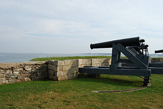
Fort Phoenix is a former American Revolutionary War-era fort located at the entrance to the Fairhaven-New Bedford harbor, south of U.S. 6 in Fort Phoenix Park in Fairhaven, Massachusetts. The fort was originally built in 1775 without a name, and added to the National Register of Historic Places in 1972. Just off the fort, in Buzzards Bay, was the first naval engagement of the American Revolution, the Battle off Fairhaven on 14 May 1775.
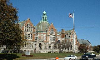
Fairhaven High School and Academy is a public high school in Fairhaven, Massachusetts, United States. Its main building, built in 1905, is known as the "Castle on the Hill" and it is part of the Fairhaven Public Schools district. The school was voted the "most beautiful high school in Massachusetts" in 2017.
The following is a timeline of the history of New Bedford, Massachusetts, United States.

Acushnet Fort was a fort that existed from 1776 to around 1820 on Eldridge Point in New Bedford, Massachusetts. It was originally built with Commonwealth resources during the American Revolution in 1776 with ten guns. Rebuilt in 1808 under the federal second system of fortifications, it could accommodate 40 men and had six guns and a magazine.

The Head of the River Historic District is a historic district encompassing a village area at the head of navigation of the Acushnet River, which separates Acushnet and New Bedford, Massachusetts. The village is centered at the junction of Tarkin Hill Road, River Road, and Mill Road in New Bedford, and Main Street in Acushnet. The area went through two significant periods of development: the first was in the late 18th and early 19th century, and the second was in the early 20th century. The district was listed on the National Register of Historic Places in 2009.
Crow Island is an inhabited island located in New Bedford Harbor in Fairhaven, Massachusetts.
Northeast Maritime Institute is a private, coeducational, maritime college offering an Associate in Applied Science in Nautical Science degree. Established in 1981, Northeast Maritime Institute is the only private maritime college in the Commonwealth of Massachusetts. The college is in the Town of Fairhaven, Massachusetts located in the United States and is within walking distance from the Acushnet River across from New Bedford Harbor. The college was originally established to provide an alternative to traditional maritime academy regimented-styled training and graduates of the college's Associate program are eligible to receive a United States Coast Guard Masters license upon graduation. The college operates a training ship, the m/v Navigator, as well as the brigantine tall ship m/s Fritha.
Massachusetts Senate's 2nd Plymouth and Bristol district in the United States is one of 40 legislative districts of the Massachusetts Senate. As of the 2010 United States Census, it includes 28.3% of Bristol County and 1.2% of Plymouth County. Since 2003, the district consists of the city of New Bedford and the towns of Acushnet, Dartmouth, and Fairhaven in Bristol County and the town of Mattapoisett in Plymouth County. From 1987 to 2003, the district consisted of Acushnet, Dartmouth, Fairhaven, and New Bedford and was numbered as the Second Bristol district.


