East Chop Light

Last updated
East Chop Light
East Chop Lighthouse.jpg
East Chop Light
LocationLighthouse Road, Oak Bluffs, Massachusetts
Coordinates 41°28′12.95″N70°34′2.825″W / 41.4702639°N 70.56745139°W / 41.4702639; -70.56745139 Coordinates: 41°28′12.95″N70°34′2.825″W / 41.4702639°N 70.56745139°W / 41.4702639; -70.56745139
Tower
Constructed1869
FoundationConcrete
ConstructionCast Iron
Automated1933
Height40 feet (12 m)
ShapeConical
MarkingsWhite with black lantern
HeritageNational Register of Historic Places listed place  OOjs UI icon edit-ltr-progressive.svg
Light
First lit1878 (current structure)
Focal height79 feet (24 m)
Lens12 inches (300 mm)
Range9 nautical miles (17 km; 10 mi)
Characteristic Isophase Green 6s
East Chop Light
Area0.1 acres (0.040 ha)
Built1876
Architectural styleItalianate
MPS Lighthouses of Massachusetts TR
NRHP reference No. 87001480 [1]
Added to NRHPJune 15, 1987

East Chop Light is a historic lighthouse standing on a bluff overlooking Vineyard Haven Harbor and Vineyard Sound, located along East Chop Drive in the town of Oak Bluffs, Massachusetts. [2] [3] [4] It is one of five lighthouses located on the island of Martha's Vineyard.

Contents

Early history

The East Chop Light was built in 1878 and added to the National Register of Historic Places in 1987. [1] In the early 1800s the location was occupied by a semaphore station - thus the origin of the name "Telegraph Hill." Circa 1869 a marine merchant named Captain Silas Daggett constructed a privately owned lighthouse on the property. To pay for construction and maintenance, Daggett collected fees from local merchants, maritime insurance agencies, and ship owners who benefited from the light as an aid-to-navigation. Daggett's 1869 lighthouse was the last of the five lighthouses to be constructed on Martha's Vineyard. The oil-fired East Chop Light burned down in 1871. The light was rebuilt by Daggett in 1872 as a house with a protruding lantern room - similar in concept to the first Edgartown Harbor Light. Daggett's new East Chop Light produced a red signal and had three 21-inch reflectors fueled by kerosene lamps. In 1875, the United States Congress purchased the property for $6,000 and removed the lighthouse and other buildings constructed by Daggett. In 1878 the present day cast-iron conical tower with a fourth-order Fresnel lens was constructed along with an adjacent two-story gabled roof keeper's house. The lighthouse was originally painted white, but was repainted as a brown-red color in the 1880s. The brown-red color was maintained until 1988, when the light was painted white by Vineyard Environmental Research, Institute (VERI). Many people in the East Chop community and elsewhere still harbor fond memories of their "Chocolate Lighthouse." In 1933 the East Chop Light was automated. At the time, the United States Coast Guard (USCG) offered to rent the Keeper's dwelling to longtime keeper, George Walter Purdy. Purdy, who had one arm, served as the East Chop Light's principal keeper for thirty-two years. Purdy refused the offer, and shortly afterwards, the keeper's dwelling, fuel oil shed, and other outbuildings were torn down. Without a keeper on the lighthouse grounds, the USCG closed the East Chop Light to public access.

Saved from destruction

From 1878 through the early 1980s, the East Chop Light was maintained by the United States Coast Guard. Due to U. S. Coast Guard Congressional funding shortages through the 1970s and early 1980s, various lighthouses around the United States were destroyed or designated for destruction. Such designation was due to the high cost of maintaining the structures, and because the lights no longer served as vital aids to navigation. This obsolete status of the lighthouses was facilitated by enhanced satellite GPS and other electrical maritime navigation aids. In fact, according to the 2012 "Doomsday List" published by Lighthouse Digest, there are currently 43 lighthouses in the U.S. listed for destruction in the near future. Due to such funding shortages, the East Chop Light and two other Martha's Vineyard lighthouses (Gay Head Light and Edgartown Harbor Light) were designated for destruction in the early 1980s. These three island lights were saved through federal petition and Congressional testimony of Vineyard Environmental Research, Inst, Founder/President, William Waterway Marks, and, Chair, John F. Bitzer, Jr. [5] During and after the Congressional hearings, this effort received support from Congressman Gerry Studds, and Senator Ted Kennedy. Shortly after the Congressional hearings, the United States Coast Guard issued a 35-year license for the three lights to VERI in 1985. [6]

This was the first time in U.S. history that control of "active" lighthouses was transferred to a civilian organization. On similar note, this was the first time in the history of Martha's Vineyard that control of any of its five lighthouses was in the hands of an island organization. After receiving the lighthouse license, the Institute undertook a series of fundraising activities that engaged the community of Martha's Vineyard, including local supporters and celebrities such as board members: Fairleigh S. Dickinson, Jr.; Jonathan Mayhew, whose ancestor's were the Vineyard's first European settlers; Vineyard Gazette co-owner, Jody Reston; philanthropist, Flipper Harris; Margaret K. Littlefield; the actress, Linda Kelsey; WHOI Director, Derek W. Spencer, [7] and John F. Bitzer, Jr. Speakers and performers appearing at these lighthouse events were renowned historian, David McCullough; Senator Ted Kennedy; Caroline Kennedy; Edward M. Kennedy, Jr.; Congressman Gerry Studds; singer/songwriter, Carly Simon; Kate Taylor; Livingston Taylor; Hugh Taylor; Dennis Miller from Saturday Night Live; Bill Styron's wife, Rose Styron - who read one of her original lighthouse poems; United States Navy Rear Admiral, Richard A. Bauman; [8] renowned photographer, Alfred Eisenstaedt and comedian, Steve Sweeney. [5] The proceeds from the lighthouse benefits were applied to a major restoration of the East Chop Light. In 1988, after consultation with the United States Coast Guard and lighthouse restoration experts, VERI changed the light's exterior color from reddish brown to white – the original color of the tower when installed in 1878. The color change from brown to white was precipitated by a VERI engineering evaluation in 1987. At the time, it was determined that the dark reddish-brown color of the cast iron exterior was causing the tower to overheat. After gaining heat during warm weather, the interior of lighthouse's cast iron would sweat from condensation, thus accelerating rust corrosion and rotting of interior wood walls on the second floor.

Public access

Public access to the East Chop Light was closed after its automation in 1933. For the first time in fifty-five years, Vineyard Environmental Research, Inst., opened the light to limited public access in 1988. This public access was allowed after VERI made extensive restoration and safety alterations of the light's interior and exterior, including an elevated lighting room exterior balcony guardrail. The extent of public access was determined after VERI held meetings with abutting property owners and the East Chop Association. As a result, VERI allowed public access to the light every Sunday during the summer season, and on special occasions such as weddings and fundraisers. The light is currently managed by the Martha's Vineyard Museum.

Lighthouse license transfer

In 1994, VERI transferred their three lighthouse licenses to the Martha's Vineyard Historical Society (MVHS), which is now known as the Martha's Vineyard Museum. At the time of the 1994 transfer, William Waterway Marks was also a member of MVHS's board, and was installed as the first Chairman of the newly formed MVHS Lighthouse Committee, where he served for four years from 1994 to 1997. [5] MV Museum board member, Craig Dripps, followed Marks as the MV Museum's Lighthouse Committee Chair, with Marks remaining as a member of the committee for several years as an advisor. The Martha's Vineyard Museum has been caretaking the three lighthouse since 1994, although the United States Coast Guard continues to own the structures. In 2003, the MV Museum paid $25,000 for a professional assessment of all three lighthouses by Gary Gredell, who had previously worked on the restoration of forty-six lighthouses on the east coast. When funds from the Community Preservation Act were made available for lighthouse restoration, the MV Museum hired Campbell Construction Group of Beverly, MA., to overhaul the lights at East Chop and Edgartown. During the summer of 2007, the East Chop Lighthouse was refurbished inside and out, with new electrical wiring, new windows (except for the ground floor), and a refurbished exterior.

Present Day

The current United States Coast Guard Light List [2] description is "White tower". The actual light is 79 feet (24 m) above Mean High Water. Through the concern and effort of the Martha's Vineyard community, the East Chop Light survives today as an iconic symbol of the island's rich maritime history. In 1987, the East Chop Light was placed on the National Register of Historic Places as East Chop Light, while under management of VERI through its United States Coast Guard license number DTCGZ71101-85-RP-007L.

East Chop Light Keepers

Silas Daggett (privately owned light 1869-1878); George Silvey (1876-1898); George H. Fisher (1898-1902); George Walter Purdy (1902-1934); William Waterway Marks (Principal Keeper 1985-1994); Bill Brown (Assistant Keeper 1985-1988); Della Hardman (Assistant Keeper 1987-1990); Elizabeth Talbot (Assistant Keeper 1985-1992).

See also

Related Research Articles

Marthas Vineyard Island south of Cape Cod, Massachusetts, U.S.

Martha's Vineyard is an island located south of Cape Cod in Massachusetts in the United States in North America that is known for being a popular, affluent summer colony. Martha's Vineyard includes the smaller adjacent Chappaquiddick Island, which is usually connected to the Vineyard. The two islands have sometimes been separated by storms and hurricanes, which last occurred from 2007 to 2015. It is the 58th largest island in the United States, with a land area of about 96 square miles (250 km2), and the third-largest on the East Coast of the United States, after Long Island and Mount Desert Island. Martha's Vineyard constitutes the bulk of Dukes County, Massachusetts, which also includes the Elizabeth Islands and the island of Nomans Land.

Edgartown, Massachusetts Town in Massachusetts, United States

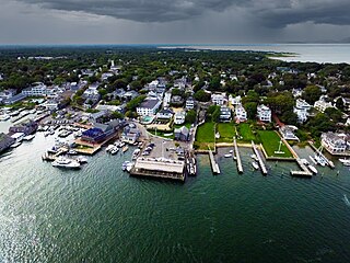
Edgartown is a tourist destination on the island of Martha's Vineyard in Dukes County, Massachusetts, United States, for which it is the county seat.

Marblehead Light (Ohio) Lighthouse in Ohio, US

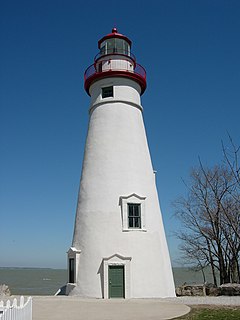
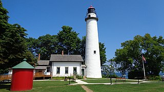
Marblehead Lighthouse in Marblehead, Ohio, United States, is the oldest lighthouse in continuous operation on the American side of the Great Lakes. It has guided sailors safely along the rocky shores of Marblehead Peninsula since 1822, and is an active aid to navigation.

Block Island Southeast Light Lighthouse in Rhode Island, United States

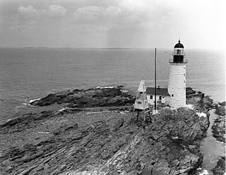
Block Island Southeast Light is a lighthouse located on Mohegan Bluffs at the southeastern corner of Block Island, Rhode Island. It was designated a U.S. National Historic Landmark in 1997 as one of the most architecturally sophisticated lighthouses built in the United States in the 19th century.

Halfway Rock Light Lighthouse in Maine, US

Halfway Rock Lighthouse is a lighthouse located on a barren ledge in Casco Bay, Maine. The lighthouse tower, which has a height of 76 feet (23 m), and the attached ex-boathouse are all that remains, as the other buildings have been taken away in storms. The name "Halfway Rock" comes from the position of the rock which is halfway between Cape Elizabeth and Cape Small, the southwest and northeast extremities of Casco Bay, which are about 18 nautical miles (33 km) apart.

Nobska Light Lighthouse

Nobska Light, originally called Nobsque Light, also known as Nobska Point Light is a lighthouse located near the division between Buzzards Bay, Nantucket Sound, and Vineyard Sound in the settlement of Woods Hole, Massachusetts on the southwestern tip of Cape Cod, Massachusetts. It overlooks Martha's Vineyard and Nonamesset Island. The light station was established in 1826, with the tower protruding above the keeper's house, and was replaced in 1876 by the current 42 foot tall iron tower. The light station was added to the National Register of Historic Places as Nobska Point Light Station in 1987.

Assateague Light Lighthouse in Virginia, United States

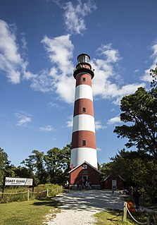
Assateague Light is the 142-foot-tall (43 m) lighthouse located on the southern end of Assateague Island off the coast of the Virginia Eastern Shore, United States. The lighthouse is located within the Chincoteague National Wildlife Refuge and can be accessed by road from Chincoteague Island over the Assateague Channel. It is owned by the U.S. Fish and Wildlife Service and operated by the U.S. Coast Guard and is still used as an active aid in navigation. The keeper's quarters are used as seasonal housing for refuge temporary employees, volunteers, and interns. Constructed in 1867 to replace a shorter lighthouse 45-foot-tall (14 m) built in 1833, the lighthouse is conical in shape and is painted in alternating bands of red and white.

Eagle Bluff Light Lighthouse

The Eagle Bluff Light, also known as Eagle Bluff lighthouse, or simply Eagle Bluff, is a lighthouse located near Ephraim in Peninsula State Park in Door County, Wisconsin. Construction was authorized in 1866, but the lighthouse was not actually built until 1868 at a cost of $12,000. It was automated in 1926. Restoration work began on the Eagle Bluff Light in 1960 and was completed in 1963, upon completion the Lighthouse was opened for tours. The lighthouse was added to the National Register of Historic Places in 1970.

Beaver Island Head Light Lighthouse in Michigan, United States

The Beaver Head Light is located high on a bluff on the southern tip of Beaver Island. Boats trying to navigate North on Lake Michigan need to carefully work their way between Beaver Island and Gray's Reef.

St. Simons Island Light Lighthouse

The St. Simons Island Light is a lighthouse on the southern tip of St. Simons Island, Georgia, United States. It guides ships into St. Simons Sound and warns of the many sandbars in the area.

West Chop Light Lighthouse

West Chop Light is a lighthouse station located at the entrance of Vineyard Haven Harbor in Tisbury, Massachusetts on the northern tip of West Chop, a few miles from the village of Vineyard Haven.

Fairleigh Stanton Dickinson Jr. was an American Republican Party politician who served as a member of the New Jersey Senate from 1968 to 1971.

Edgartown Harbor Light Lighthouse

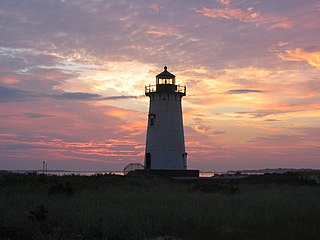
Edgartown Harbor Light is a lighthouse located in Edgartown, Massachusetts, United States, where it marks the entrance to Edgartown Harbor and Katama Bay. It is one of five lighthouses on the island of Martha's Vineyard. The first lighthouse, a two-story wooden structure that also served as the keeper's house, was constructed in 1828. It was demolished, and replaced by the current cast-iron tower, in 1939. Originally located on an artificial island 1/4 miles from shore, the lighthouse is now surrounded by a beach formed, since 1939, by sand accumulating around the stone causeway connecting it to the mainland.

Pointe aux Barques Light Lighthouse in Michigan, United States

Pointe aux Barques Lighthouse is an active lighthouse located in Huron County in the U.S. state of Michigan. It is located along the shores of Lake Huron on the northeastern tip of the Thumb. Originally constructed in 1848, it is one of the oldest active lighthouses in the state. The name is translated as "point of little boats" from the French language, which refers to the shallow coastline that poses a threat to larger boats.

Dutch Island Light Lighthouse

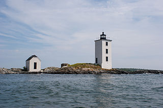
Dutch Island Light is a historic lighthouse on Dutch Island off Jamestown, Rhode Island.

Gay Head Light Lighthouse

Gay Head Light is a historic lighthouse located on Martha's Vineyard westernmost point off of Lighthouse Road in Aquinnah, Massachusetts.

Brenton Reef Light Lighthouse

The Brenton Reef Light was a Texas tower lighthouse at the entrance to Narragansett Bay, Rhode Island, United States, south of Beavertail Point. Erected to replace a lightship in 1962, it was decommissioned in 1989 due to its deteriorating condition.

Naval Auxiliary Air Station Martha's Vineyard was a United States Navy facility located in Edgartown and West Tisbury, Massachusetts operational from 1943 to 1946. It existed as an auxiliary air facility of Naval Air Station Quonset Point.

North Point Light Lighthouse

The North Point Lighthouse Museum is a lighthouse built in 1888 in Lake Park on the East Side of Milwaukee in Milwaukee County, Wisconsin, United States to mark the entrance to the Milwaukee River. The lighthouse was added to the National Register of Historic Places in 1984. It was also added to the Library of Congress Historic American Buildings Survey as survey HABS WI-358.

Gannet Rock Lighthouse Lighthouse

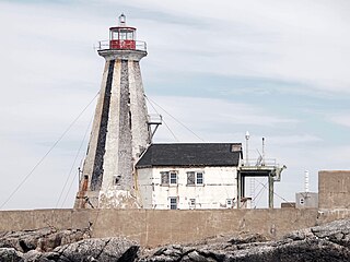
The Gannet Rock Lighthouse is a Canadian lighthouse located on a rocky islet 8 miles (13 km) south of Grand Manan in the Bay of Fundy. It was first lit in 1831 and was staffed until 1996. It was solarized in 2002 and remains operational in 2022. It was declared "surplus to requirements" by the Canadian Coast Guard in 2010 and is no longer being maintained.

References

  1. 1 2 "National Register Information System". National Register of Historic Places . National Park Service. April 15, 2008.
  2. 1 2 Light List, Volume I, Atlantic Coast, St. Croix River, Maine to Shrewsbury River, New Jersey (PDF). Light List. United States Coast Guard. 2010. p. 121.
  3. "Historic Light Station Information and Photography: Massachusetts". United States Coast Guard Historian's Office. Archived from the original on 2017-05-01.
  4. Rowlett, Russ. "Lighthouses of the United States: Southeast Massachusetts". The Lighthouse Directory. University of North Carolina at Chapel Hill.
  5. 1 2 3 "Saving Lighthouses on Martha's Vineyard". Lighthouse Digest. December 2010. Retrieved 21 March 2012.
  6. VERI
  7. Dawicki, Shelley. "In Memoriam: Derek K. Spencer". Woods Hole Oceanographic Institution. Media Relations Office, WHOI. Retrieved 3 March 2012.
  8. Holley, Joe. "Richard Arnold Bauman". Coast Guard Admiral Richard A. Bauman Dies. The Washington Post. Retrieved 3 March 2012.