
Nobska Light, originally called Nobsque Light, also known as Nobska Point Light is a lighthouse located near the division between Buzzards Bay, Nantucket Sound, and Vineyard Sound in the settlement of Woods Hole, Massachusetts on the southwestern tip of Cape Cod, Massachusetts. It overlooks Martha's Vineyard and Nonamesset Island. The light station was established in 1828, with the tower protruding above the keeper's house, and was replaced in 1876 by the current 42 foot tall iron tower. The light station was added to the National Register of Historic Places as Nobska Point Light Station in 1987.

The Sankaty Head Light is a lighthouse located on Nantucket island. It was built in 1850, was automated in 1965, and is still in operation. It is located at the easternmost point of the island, in the village of Siasconset. It was one of the first lighthouses in the United States to receive a Fresnel lens.

Brant Point Light is a lighthouse located on Nantucket Island. The station was established in 1746, automated in 1965, and is still in operation. The current tower was added to the National Register of Historic Places on October 28, 1987; it has the distinction of being the tenth light on the point, in addition to several range lights. Four of the others burned or blew down, two were condemned, two were unsatisfactory, and the remaining one stands unused.

The Highland Light is an active lighthouse on the Cape Cod National Seashore in North Truro, Massachusetts. The current tower was erected in 1857, replacing two earlier towers that had been built in 1797 and 1831. It is the oldest and tallest lighthouse on Cape Cod.
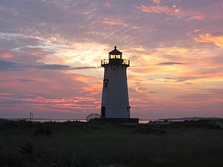
Edgartown Harbor Light is a lighthouse located in Edgartown, Massachusetts, United States, where it marks the entrance to Edgartown Harbor and Katama Bay. It is one of five lighthouses on the island of Martha's Vineyard. The first lighthouse, a two-story wooden structure that also served as the keeper's house, was constructed in 1828. It was demolished, and replaced by the current cast-iron tower, in 1939. Originally located on an artificial island 1/4 miles from shore, the lighthouse is now surrounded by a beach formed, since 1939, by sand accumulating around the stone causeway connecting it to the mainland.

Long Island Head Light is an historic lighthouse on Long Island in Boston Harbor, Boston, Massachusetts. The current brick tower is the fourth lighthouse on the island.

Eastern Point Light is a historic lighthouse on Cape Ann, in northeastern Massachusetts.It is known as the oldest seaport in America. The harbor has supported fishermen, whalers, and traders since 1616.

West Dennis Light is a lighthouse in West Dennis, Massachusetts. It was previously known as Bass River Light. It is owned by and sits on top of the Lighthouse Inn, a seasonal hotel.

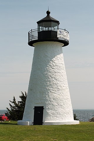
Bird Island Light is a historic lighthouse at the entrance to Sippican Harbor in Marion, Massachusetts. Built in 1819, its tower is a well-preserved example of an early 19th-century masonry lighthouse. The tower and the island on which it stands were added to the National Register of Historic Places as Bird Island Light on September 28, 1987.
Ned Point Light is a historic lighthouse on Ned's Point Road in Mattapoisett, Massachusetts. The lighthouse was built in 1838 at a cost of approximately $5,000, and named after Ned Dexter, a local farmer. Under the supervision of a local builder, Leonard Hammond, the lighthouse was constructed with a birdcage-style lantern similar to Bird Island Light found in Marion, Massachusetts. The stone used for the lighthouse was all locally sourced, with most of it originating from nearby beaches. Inside, there are 32 granite steps that are cantilevered to the outside wall without the use of mortar. The original lantern used 11 whale oil lamps, each with its own parabolic reflector. The lamps and reflectors were replaced by a fifth order Fresnel lens in 1857, along with a change to an octagonal lantern. The Great Blizzard of 1888 significantly damaged the keeper's stone house, resulting in it being demolished and the building of a wooden replacement.

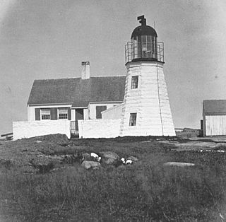
Bakers Island Light is a historic lighthouse on Bakers Island in Salem, Massachusetts. The station was originally established in 1791, with a daymark. This was replaced in 1798 by two lights atop a keeper's house, one at each end. After storm damage in 1815, an octagonal stone tower was constructed. The current round stone tower was added in 1820. The 1820 tower was taller, leading to the names "Ma" and "Pa". The two remained in service until 1926, when the older, shorter tower was removed.

Annisquam Harbor Light Station is a historic lighthouse on Wigwam Point in the Annisquam neighborhood of Gloucester, Massachusetts. It can be viewed from nearby Wingaersheek Beach, Gloucester. It lies on the Annisquam River and is one of the four oldest lighthouses to surround the Gloucester peninsula as well as; Eastern Point Light, Ten Pound Island Light, and Thacher Island Light.
The Ten Pound Island Light is a historic lighthouse in Gloucester Harbor in Gloucester, Massachusetts. It is located on Ten Pound Island, near the eastern end of the harbor. The tower, built in 1881, is a conical cast iron structure 30 feet (9.1 m) tall, replacing a stone tower first built on the site in 1821. The main body is painted white, and the top is painted black.

Deer Island Light is a lighthouse in Boston Harbor, Boston, Massachusetts. The actual light is 53 feet (16 m) above Mean High Water. Its alternating white and red light is visible for 9 nautical miles.

Great Duck Island Light is a lighthouse on Great Duck Island in the town of Frenchboro, Maine, USA. Established in 1890, the light marks the approach to Blue Hill Bay and the southern approaches to Mount Desert Island on the central coast of Maine. The light was listed on the National Register of Historic Places as Great Duck Island Light Station on March 14, 1988. The light is an active aid to navigation maintained by the United States Coast Guard; the property is owned by the College of the Atlantic, which operates a research station there.

Cuttyhunk Light was a lighthouse at the west end of Cuttyhunk Island, Massachusetts. First established in 1823, it was rebuilt several times. The last lighthouse was built in 1891, with a 5th order Fresnel Lens in a 45-foot (14 m) tower. This was heavily damaged in the Great Atlantic Hurricane of 1944 and was torn down in 1947 and replaced by a skeleton tower. The keeper's house was also destroyed. The skeleton tower was discontinued in 2005. Only a stone oil house remains from the lighthouse station, missing its door and roof.

Stage Harbor Light is a lighthouse in Chatham, Massachusetts built in 1880. It was discontinued in 1933, replaced by a skeleton tower 200 ft (60m) west which remains an active aid to navigation. The original light helped to mark a vessel staging area anchorage in deep water south of Harding's Beach used during periods of low visibility (fog) by vessels waiting to round Monomoy Point and Pollock Rip Channel. The lighthouse also lined up perfectly with the Chatham Twin Lights, making an effective range for Chatham Roads, the deep water channel crossing Nantucket Sound from south of Bishop & Clerks Reef off Point Gammon at Hyannis to the staging area. The original light is now a private residence. It sits at the entrance of what is still a busy harbor, used primarily by Chatham-based fishing fleets, sailboats from the Stage Harbor and Monomoy yacht clubs, and private craft owners.
The Nantucket Harbor Range Lights are range lights that were built in 1908 to guide vessels through the narrow channel to Nantucket Harbor. They replaced an older arrangement involving the Nantucket Beacon and the Brant Point Light, which became unusable when the latter was replaced with a new tower.


