
ROTOR was an elaborate air defence radar system built by the British Government in the early 1950s to counter possible attack by Soviet bombers. In order to get it operational as quickly as possible, it was initially made up primarily of WWII-era systems, notably the original Chain Home radars for the early warning role, and the AMES Type 7 for plotting and interception control. The system had a network of control stations, mostly built underground, and connected with an extensive telephone and telex network.

Church Ope Cove is a small secluded beach on the sheltered eastern side of the Isle of Portland in Dorset, southern England and is part of the Jurassic Coast. It is found close to the village of Wakeham. The beach has many unusual features for the Isle of Portland. The beach used to be sandy, but quarry debris now covers the sand, and has been worn into rounded pebbles. The pebbles cover a small stream which runs to the sea, which is one of the few active streams remaining on the Isle of Portland.

Pulpit Rock is a coastal feature at Portland Bill, the southern tip of the Isle of Portland, Dorset, England. Representing an open bible leaning on a pulpit, Pulpit Rock was formed in the 1870s after a natural arch was cut away by quarrymen at Bill Quarry. As a quarrying relic, the rock is similar to that of Nicodemus Knob, another quarrying landmark on the island.

The Portland is a sheep breed that takes its name from the Isle of Portland in Dorset, England. This breed is raised primarily for meat.

RAF Ash was an RAF underground control centre and radar station situated near the village of Woodnesborough, Kent, England.
Portland was a railway station on the Portland Branch Railway in the west of the English county of Dorset. Opened with the Weymouth and Portland railway, one of the constituent parts of a complex line, on 16 October 1865, the station was moved to a new site on the opening of the extension to Easton on 1 September 1902.

Balaclava Bay is a bay situated on the edge of Portland Harbour, where the breakwater meets the island, at the northern end of the Isle of Portland, Dorset, in southern England. The bay is part of the Jurassic Coast, a World Heritage Site. The bay is overlooked by the Victorian East Weare Battery, built in the 1860s to protect the harbour. The nearest road within the dockyard of Portland Port is named Balaclava Road.
The Grove is a small village located at Tophill on the Isle of Portland in Dorset. The village is found close to the larger village Easton, and is most notable for containing the Youth Offender's Institute HM Prison Portland, including its museum Grove Prison Museum. As with the rest of Portland's villages and settlements, The Grove has been designated as a conservation area, as it is a place of special architectural and historic interest. The village was designated in 1981.

Hallelujah Bay is a bay located on the west side of the Isle of Portland, Dorset, England. The bay is situated below West Weares, with Clay Ope, Blacknor Point and Mutton Cove further south. Near the cove is a large mound of rock and earth beneath the clifftops known locally as the Green Hump.

Mutton Cove is a cove, located on the Isle of Portland, Dorset, England; part of the Jurassic Coast. It is found on the west side of Portland. Presumably named after the once-famous Portland sheep, the cove is an erosional indentation just south of the promontory of Blacknor. On the cliff tops of the cove is part of the South West Coast Path and further south is Wallsend Cove and Portland Bill.

Governor's Community Garden is a public garden, located on the Isle of Portland, Dorset, England. It is found within The Grove village, opposite the site of HM Prison Portland.
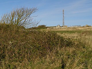
RAF Portland is a former Royal Air Force and ROTOR radar station on the Isle of Portland, Dorset, England. Located close to the Verne Citadel and East Cliff, the station was established in the 1950s as part of a nationwide air defence radar system built by the British Government during the Cold War. The station became a scheduled monument in 2004 and now the site of Fancy's Family Farm.

Freshwater Bay is a bay on the east side of the Isle of Portland, Dorset, England, south from Church Ope Cove and between the villages of Wakeham and Southwell. It forms part of the Jurassic Coast.

NCI Portland Bill is a National Coastwatch Institution (NCI) lookout station on the Isle of Portland, Dorset, England. The station is situated 50 metres above sea level on the cliff edge, half a mile north of the tip of Portland Bill. It is located close to the Old Higher Lighthouse.

Merchant's Railway was a horse drawn and cable operated incline railway on the Isle of Portland, Dorset, England, built for the stone trade on the island. It was the earliest railway in Dorset, opening in 1826. The railway ran two miles from many working quarries at the north of Tophill, along the edge of Verne Hill, to a pier at Castletown, from where the Portland stone was shipped. It was in operation from 1826 to 1939. Since becoming disused the original path of the railway has become a popular public footpath.

Verne Cistern is a water supply cistern on the Isle of Portland, Dorset, England. It is situated at the southern flank of the Verne Ramparts, on the slopes of Verne Hill, along the route of the horse drawn and cable operated Merchant's Railway - now a public footpath. It is on the edge of the Verne Citadel, a 19th-century fort, which is now HM Prison The Verne. The cistern became Grade II Listed in May 1993.

Verne Heavy Anti-Aircraft Battery is a World War II anti-aircraft battery on the Isle of Portland, Dorset, England. It is located on private property in the north-east area of the island, south of the Verne Citadel. The battery became a scheduled monument in March 2019.

Coombefield Quarry is an active stone quarry located on the Isle of Portland, Dorset, England. It is situated near the island's southernmost village Southwell. The large quarry has been worked over many years, and has two voids known as Coombefield North and Coombefield South. The quarry today incorporates the former Suckthumb Quarry, which is situated at the northwest part of the quarry, and is now filled in. The quarry is owned by Portland Stone Firms Ltd, along with Broadcroft and Perryfield Quarry. The firm is the largest landholder on the island.

The Battle of Douvres Radar Station was a military engagement of World War II as part of the Invasion of Normandy, that took place on the 17 June 1944. The attack was by British 41 Commando, Royal Marines, the station and area were defended mainly by Luftwaffe ground forces. Preceded by an artillery bombardment and supported by mine-clearing and anti-bunker tanks of 79th Armoured Division, the Royal Marines were able to secure the surrender of the garrison.


