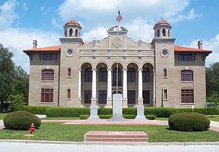
Sumter County is a county located in the state of Florida, United States. As of September 2016, the population according to county officials is 118,577. It has the oldest median age of any US county. Its county seat is Bushnell, and the largest community is The Villages.

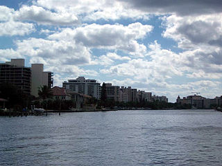
Hillsboro Beach, officially known as the Town of Hillsboro Beach, is a town in Broward County, Florida, United States. The population was 1,981 at the 2010 census. It is part of the Miami metropolitan area, which was home to 5,564,635 people at the 2010 census.

Lauderdale Lakes, officially the City of Lauderdale Lakes, is a city in Broward County, Florida, United States. As of the 2010 United States Census, the city's population was 32,593. It is part of the Miami–Fort Lauderdale–West Palm Beach Metropolitan Statistical Area, which is home to 5,564,635 people.

Carol City is a neighborhood in Miami Gardens, Florida, United States. The population was 61,233 at the 2010 census.

El Portal is a village in Miami-Dade County, Florida, United States. The village name is derived from the Spanish term for "the gate," after two wooden gates that once stood as a gateway to the village. El Portal was originally a neighborhood of the City of Miami when it was annexed into the City of Miami in 1925. With the arrival of the Great Depression, the City of Miami gave up its jurisdiction and El Portal was incorporated as its own village in 1937.

Goulds is a census-designated place (CDP) in Miami-Dade County, within the U.S. state of Florida. The area was originally populated as the result of a stop on the Florida East Coast Railroad. The railroad depot was located near the current Southwest 224th Street. The community was named after its operator, Lyman Gould, who cut trees for railroad ties. As of the 2009 census, the population stood at 10,103.

Ojus is a census-designated place and formerly incorporated town in Miami-Dade County, Florida, United States. The population was 16,642 at the 2000 census. Ojus is bordered by Aventura to the east, I-95 to the west, North Miami Beach to the south and Broward County to the north.

Pinecrest is an affluent suburban village in Miami-Dade County, Florida, United States of America. The population was 18,223 as of the census of 2010. Pinecrest is governed by a five-member Village Council and operates under the Council-Manager form of government. 33156, the zip code that encompasses most of the village, has been consistently ranked as one of the most expensive in the United States.

Islamorada is an incorporated village in Monroe County, Florida, United States. It is located on five islands—Tea Table Key, Lower Matecumbe Key, Upper Matecumbe Key, Windley Key and Plantation Key—in the Florida Keys.

Boca Pointe was a census-designated place (CDP) located in an unincorporated area near Boca Raton in Palm Beach County, Florida, United States. The population was 3,302 at the 2000 census. The CDP was not included in the 2010 census. While it is not officially in the City of Boca Raton, the community is frequently classified under its umbrella term.
Highland Beach is a town in Palm Beach County, Florida, United States. As of 2007, the population recorded by the U.S. Census Bureau was 3,988.
Lake Harbor is a census-designated place (CDP) in Palm Beach County, Florida, United States. The population was 195 at the 2000 census. It located along the southern banks of Lake Okeechobee, at the beginning of the Miami Canal. John Stretch Park is also located alongside the north end of Lake Harbor and the lake.
Unbelievable Acres Botanic Gardens is a private man-made, nonprofit botanical garden located at 470 63rd Trail North, West Palm Beach, Florida, United States.
Suntree is an unincorporated community in Brevard County, Florida, United States. It is located near the center of the county, off I-95 near Viera between Interstate 95 and the Florida East Coast Railroad. It lies approximately halfway between Rockledge and Melbourne.

Pekin Township is located in Tazewell County, Illinois. As of the 2010 census, its population was 29,807 and it contained 13,321 housing units.
Deem City is a ghost town in Palm Beach County, Florida, United States, located approximately 15 miles (24 km) northwest of Weston on U.S. Route 27, near the Palm Beach/Broward county line.
Garden Cove is an unincorporated community in Monroe County, Florida, United States, located in the upper Florida Keys on Key Largo immediately southwest and bordering the Census-designated place (CDP) of North Key Largo.

Buena Vista is a neighborhood in Miami, Florida, United States. It is located south of Little Haiti, north of the Miami Design District.

Okeelanta is an unincorporated community in Palm Beach County, Florida, United States, located approximately 4 miles (7 km) south of South Bay on U.S. Route 27 at County Road 827. The name is a blend of Lake Okeechobee and Atlantic Ocean.
Pelican Lake is the former name of a small unincorporated community in Palm Beach County, Florida, United States, located north of Belle Glade, south-southeast of Canal Point, and east of Pahokee. Pelican Lake is on the south side of State Road 717.


