Lauderdale-by-the-Sea, Florida

Last updated

Lauderdale-by-the-Sea
Lauderdale By The Sea - Anglin's Pier 9 of 9 (50661033743).jpg
The beach is the main visitor attraction of Lauderdale-by-the-Sea
Nickname: 
LBTS
Map of Florida highlighting Lauderdale-by-the-Sea.svg
Location of Lauderdale-by-the-Sea in Broward County, Florida
Coordinates: 26°11′22″N80°5′52″W / 26.18944°N 80.09778°W / 26.18944; -80.09778
Country Flag of the United States.svg  United States
State Flag of Florida.svg  Florida
County Broward
Settled c. 1920s–1924 [1]
Incorporated November 30, 1927 [1] [2]
Reincorporated November 30, 1947 [1]
Government
  Type Commission-Manager
   Mayor Christopher Vincent
   Vice Mayor Edmund Malkoon
   Commissioners Alfred "Buz" Oldaker,
Theo Poulopoulos, and
Randy Strauss
   Town Manager Linda Connors
   Town Clerk Katrina Adler
Area
[3]
  Total0.94 sq mi (2.43 km2)
  Land0.88 sq mi (2.27 km2)
  Water0.06 sq mi (0.16 km2)  44.2%
Elevation
7 ft (2.13 m)
Population
 (2020)
  Total6,198
  Density7,067.27/sq mi (2,729.44/km2)
Time zone UTC-5 (EST)
  Summer (DST) UTC-4 (EDT)
ZIP code
33308, 33062
Area code(s) 954, 754
FIPS code 12-39475 [4]
GNIS feature ID0285367 [5]
Website http://www.lauderdalebythesea-fl.gov/
Shops and restaurants around the intersection of Commercial Boulevard and A1A in Lauderdale-by-the-Sea Lauderdale-by-the Sea South Florida January 2018 08.jpg
Shops and restaurants around the intersection of Commercial Boulevard and A1A in Lauderdale-by-the-Sea

Lauderdale-by-the-Sea is a town in Broward County, Florida, United States, situated 33 miles north of Miami. The town is part of the South Florida metropolitan area. As of the 2020 census, the population was 6,198.

Contents

Geography

Lauderdale-by-the-Sea is located at 26°11′22″N80°5′52″W / 26.18944°N 80.09778°W / 26.18944; -80.09778 (26.189561, –80.097756). [6] According to the United States Census Bureau, the town has a total area of 1.57 square miles (4 km2), of which 0.876 square miles (2 km2) is land and 0.694 square miles (2 km2) (44.2%) is water.

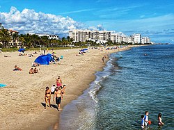
The southern half of Lauderdale-by-the-Sea is situated between Fort Lauderdale and the Village of Sea Ranch Lakes, Florida. The Town's northern municipal neighbor is Pompano Beach. The entire town is located on a long, narrow barrier island separated from the mainland by the Intracoastal Waterway (spanned by one drawbridge at Commercial Boulevard), stretching approximately one-half dozen blocks to the Atlantic Ocean. The town is centered on the junction of State Road A1A and Commercial Boulevard. The main industry is tourism; the town has many hotels and motels used by visitors, especially during the winter; many of its older hotels and buildings reflect mid-century modern architecture design [MiMo]. Recognized by the Florida Legislature in 2016 for its near-shore coral reefs and efforts to promote scuba diving, the town is known as Florida's Beach Diving Capital. With a coral reef just 100 yards offshore, the town is a popular spot for scuba divers, especially just south of Anglin's Pier.[ citation needed ]

On the ocean at the east end of Commercial Boulevard is Anglin's Fishing Pier, named after Lauderdale-by-the-Sea's first mayor, Melvin I. Anglin. [1] [7] The town is home to SS Copenhagen, a 19th-century British steamship that wrecked in 25 feet of water in May 1900 after striking a coral reef. The historic site is a Florida archaeological underwater preserve and is listed on the National Register of Historic Places. [8] The town doubled in size in 2001 when it annexed the unincorporated Intracoastal Beach Area to the north. The area included the neighborhoods of Bel Air and Terra Mar Island. Even though the town's permanent population is 6,056, it nearly doubles when snowbirds and tourists come here to spend the winter. The Town underwent a major transformation in 2013, when it completed a streetscape project between the Commercial Boulevard Bridge and the ocean. Sidewalks were widened and enhanced with brick pavers as well as landscaping.[ citation needed ]

Two new public plazas were added in Anglin's Square and furnished with colorful "Addy" chairs, boat benches and bike racks shaped like fish. Each of the four business plazas on Commercial were outfitted with coral reef themed artworks (parrotfish, green turtle, eagle ray and sea fan), reflecting the town's ties with the ocean. An 18-foot coral reef sculpture also greets visitors as they enter the town over the intracoastal waterway.

Demographics

Historical population
CensusPop.Note
1950 234
1960 1,327467.1%
1970 2,879117.0%
1980 2,639−8.3%
1990 2,99013.3%
2000 2,563−14.3%
2010 6,056136.3%
2020 6,1982.3%
U.S. Decennial Census [9]

2020 census

Lauderdale-by-the-Sea racial composition
(Hispanics excluded from racial categories)
(NH = Non-Hispanic) [10]
RaceNumberPercentage
White (NH)5,08181.98%
Black or African American (NH)861.39%
Native American or Alaska Native (NH)20.03%
Asian (NH)901.45%
Pacific Islander or Native Hawaiian (NH)60.10%
Some other race (NH)410.66%
Two or more races/Multiracial (NH)2023.26%
Hispanic or Latino (any race)69011.13%
Total6,198100.00%

As of the 2020 United States census, there were 6,198 people, 3,756 households, and 1,725 families residing in the town. [11]

2010 census

Lauderdale-by-the-Sea Demographics
2010 Census Lauderdale-by-the-SeaBroward CountyFlorida
Total population6,0561,748,06618,801,310
Population, percent change, 2000 to 2010+136.3%+7.7%+17.6%
Population density6,916.1/sq mi1,444.9/sq mi350.6/sq mi
White or Caucasian (including White Hispanic)96.3%63.1%75.0%
(Non-Hispanic White or Caucasian)88.2%43.5%57.9%
Black or African-American 1.2%26.7%16.0%
Hispanic or Latino (of any race) 8.8%25.1%22.5%
Asian 0.8%3.2%2.4%
Native American or Native Alaskan 0.1%0.3%0.4%
Pacific Islander or Native Hawaiian 0.0%0.1%0.1%
Two or more races (Multiracial) 0.9%2.9%2.5%
Some Other Race 0.7%3.7%3.6%

As of 2010, there were 6,563 households, out of which 45.2% were vacant.

Media

Lauderdale-by-the-Sea is a part of the Miami-Fort Lauderdale-Hollywood media market, which is the twelfth largest radio market [12] and the seventeenth largest television market [13] in the United States. Its primary daily newspapers are the South Florida Sun-Sentinel and The Miami Herald . There are currently no newspapers based in Lauderdale-by-the-Sea, although the neighboring weekly, The Pompano Pelican regularly covers the community.

Education

Broward County Public Schools operates public schools. Zoned schools include: [14]

In addition the community is in the service area of the magnet school Pompano Beach High School. [22]

Related Research Articles

<span class="mw-page-title-main">Broward County, Florida</span> County in Florida, United States

Broward County is a county in the southeastern part of Florida, located in the Miami metropolitan area. It is Florida's second-most populous county after Miami-Dade County and the 17th-most populous in the United States, with 1,944,375 residents as of the 2020 census. Its county seat and largest city is Fort Lauderdale, which had a population of 182,760 as of 2020.

<span class="mw-page-title-main">Dania Beach, Florida</span> City in Broward County, Florida, United States

Dania Beach is a city in Broward County, Florida, United States. It is part of the South Florida metropolitan area. As of the 2020 census, the city's population was 31,723. Dania Beach is the location of one of the largest jai alai frontons in the United States, The Casino at Dania Beach. It was formerly the location for two amusement centers; one named Boomers!, which housed the Dania Beach Hurricane roller coaster, and the other being Pirates World amusement park, which was featured in Barry Mahon's Thumbelina. It is also home to the International Game Fish Association Hall of Fame and Museum.

<span class="mw-page-title-main">Fort Lauderdale, Florida</span> City in Florida, United States

Fort Lauderdale is a coastal city located in the U.S. state of Florida, 30 miles (48 km) north of Miami along the Atlantic Ocean. It is the county seat of and largest city in Broward County with a population of 182,760 at the 2020 census, making it the tenth largest city in Florida. After Miami and Hialeah, Fort Lauderdale is the third largest city in the Miami metropolitan area, which had a population of 6,166,488 in 2019.

<span class="mw-page-title-main">Hillsboro Beach, Florida</span> Town in the state of Florida, United States

Hillsboro Beach, officially the Town of Hillsboro Beach, is a town in Broward County, Florida, United States. The town is part of the Miami metropolitan area. Its population was 1,987 at the 2020 census.

<span class="mw-page-title-main">Lazy Lake, Florida</span> Village in Florida

Lazy Lake is a village in Broward County, Florida, United States. The village is part of South Florida's Miami metropolitan area. It has no police department or fire department. The population was 33 at the 2020 census.

<span class="mw-page-title-main">Lighthouse Point, Florida</span> City in Florida

Lighthouse Point, officially the City of Lighthouse Point, is a suburb of Fort Lauderdale located in Broward County, Florida, United States. The suburb was named for the Hillsboro Inlet Lighthouse, which is located in nearby Hillsboro Beach. The city is a part of the Miami metropolitan area of South Florida. As of the 2020 census, the population of Lighthouse Point was 10,486.

<span class="mw-page-title-main">North Lauderdale, Florida</span> City in Florida

North Lauderdale is a city in Broward County, Florida, United States. It is a principal city of the Miami metropolitan area. As of the 2020 census, the city's population was 44,794.

<span class="mw-page-title-main">Parkland, Florida</span> City in Florida, United States

Parkland is a suburban city, 42 miles northwest of Miami, in northern Broward County, Florida, United States. As of the 2020 census, the population of Parkland was 34,670. Parkland is part of the Miami metropolitan area, which was home to 6,166,488 people in 2020.

<span class="mw-page-title-main">Pompano Beach, Florida</span> City in Florida, United States

Pompano Beach is a city in Broward County, Florida. It is located along the coast of the Atlantic Ocean, just north of Fort Lauderdale. The nearby Hillsboro Inlet forms part of the Atlantic Intracoastal Waterway. It is a principal city of the Miami metropolitan area, which was home to 6.14 million people in 2020. As of the 2020 census, the population was 112,046, making it the sixth-largest city in Broward County, the ninth-largest city in the South Florida metropolitan area, and the 20th-largest city in Florida.

<span class="mw-page-title-main">Sea Ranch Lakes, Florida</span> Village in Florida

Sea Ranch Lakes is a village in Broward County, Florida, United States. The village is part of South Florida's Miami metropolitan area. It is located on North Ocean Drive and is surrounded by Lauderdale-by-the-Sea. The majority of the village is a gated community, with the remainder being a public shopping plaza and a private beach club for village residents, with a pool and access to Sea Ranch Lakes Beach. The population was 540 at the 2020 census.

<span class="mw-page-title-main">Tamarac, Florida</span> City in Florida, United States

Tamarac is a city in Broward County, Florida, United States. It is part of the Miami metropolitan area. At the 2020 census, the city had a population of 71,897.

<span class="mw-page-title-main">Wilton Manors, Florida</span> City in Florida, United States

Wilton Manors is a city in Broward County, Florida, United States. Wilton Manors is part of the Miami metropolitan area, which was home to 6,166,488 people at the 2020 census. As of the 2020 census, the city had a population of 11,426.

<span class="mw-page-title-main">Las Olas Boulevard</span>

Las Olas Boulevard is a major east-west thoroughfare in Fort Lauderdale, Florida, United States that runs from SW 1st Avenue in the Central Business District to Florida State Road A1A in Fort Lauderdale Beach. The name "Las Olas" means "The Waves" in Spanish. The road once carried the designations of State Road A1A Alt. and State Road 842.

<span class="mw-page-title-main">Miami metropolitan area</span> Metropolis in the U.S. state of Florida

The Miami metropolitan area, and officially known as the Miami–Fort Lauderdale–West Palm Beach Metropolitan Statistical Area, is a coastal metropolitan area in southeastern Florida. It is the ninth-largest metropolitan statistical area in the United States, the fifth-largest metropolitan area in the Southern United States, and the largest metropolitan area in Florida. With a population of 6.14 million, its population exceeds 31 of the nation's 50 states as of 2022. It comprises the three most populated counties in the state, Miami-Dade County, Broward County, and Palm Beach County, which rank as the first, second, and third-most populous counties in the state, respectively. Miami-Dade County, with 2,716,940 people in 2019, is the seventh-most populous county in the United States.

<span class="mw-page-title-main">Dixie Highway (Broward–Palm Beach)</span>

Dixie Highway in Palm Beach and Broward counties carries two segments of the State Road 811 designation by Florida Department of Transportation, as well as the local County Road 811 in southeast Florida. The entire road comprises a section of the Dixie Highway, a National Auto Trail which eventually became a former routing of U.S. Route 1 after the route was shifted east to Federal Highway. One segment of SR 811 is in Broward County and the other is in Palm Beach County, Florida. The segments of SR 811 are supplemented by three shorter segments of CR 811, one of which is unsigned.

<span class="mw-page-title-main">Broward County Library</span> Public library system in Florida

The Broward County Library is a public library system in Broward County, Florida, in the United States. The system contains 38 branch locations and circulates over 10.5 million items annually. The system includes the Main Library in Fort Lauderdale, five regional libraries, and various branches.

<span class="mw-page-title-main">Florida's 23rd congressional district</span> U.S. House district for Florida

Florida's 23rd congressional district is an electoral district for the U.S. Congress, located in the Greater Miami area and covering parts of Broward County and southern Palm Beach County. In the 2020 redistricting cycle, it was drawn as a successor to the previous 22nd district and includes Boca Raton, Coral Springs, most of Deerfield Beach and Fort Lauderdale, and parts of Pompano Beach. The previous iteration of the 23rd district, which included Davie and Pembroke Pines, was instead renamed the 25th district. The district, along with two other districts in Greater Miami, has one of the highest concentrations of Jewish Americans, consisting of about 16% of the electorate.

The history of Fort Lauderdale, Florida began more than 4,000 years ago with the arrival of the first aboriginal natives, and later with the Tequesta Indians, who inhabited the area for more than a thousand years. Though control of the area changed among Spain, England, the United States, and the Confederate States of America, it remained largely undeveloped until the 20th century. The first settlement in the area was the site of a massacre at the beginning of the Second Seminole War, an event which precipitated the abandonment of the settlement and set back development in the area by over 50 years. The first United States stockade named Fort Lauderdale was built in 1838, and subsequently was a site of fighting during the Second Seminole War. The fort was abandoned in 1842, after the end of the war, and the area remained virtually unpopulated until the 1890s.

South Florida Chamber Maps is a Broward County, Florida print and digital map company. Started in 2011, the company first printed humorous cartoon style maps that showed fun, local things to do in specific Broward County towns and cities including Weston, Coral Springs, Plantation, Pompano Beach, Lauderdale-By-The-Sea and Deerfield Beach. The guides are produced in collaboration with each city's chamber of commerce in order to lend credibility and accuracy to the projects. The maps are considered to be an important part of the northern Broward communities efforts to build regional tourism.

References

  1. 1 2 3 4 "Town of Lauderdale-By-The-Sea: A little history - A brief history of Lauderdale-By-The-Sea". www.lauderdalebythesea-fl.gov/. Retrieved July 15, 2015.
  2. "Broward-by-the-Numbers" (PDF). www.broward.org. pp. 3–5. Archived from the original (PDF) on October 10, 2015. Retrieved July 15, 2015.
  3. "2020 U.S. Gazetteer Files". United States Census Bureau. Retrieved October 31, 2021.
  4. "U.S. Census website". United States Census Bureau . Retrieved January 31, 2008.
  5. "US Board on Geographic Names". United States Geological Survey. October 25, 2007. Retrieved January 31, 2008.
  6. "US Gazetteer files: 2010, 2000, and 1990". United States Census Bureau. February 12, 2011. Retrieved April 23, 2011.
  7. "Lauderdale-By-The-Sea Chamber of Commerce: Fishing". www.lbts.com/. Retrieved July 15, 2015.
  8. "Fort Lauderdale Scuba Diving Beach Dive Site | LBTS Shipwreck Snorkel Trail". Sink, Florida, Sink!. Retrieved February 28, 2013.
  9. "Census of Population and Housing". Census.gov. Retrieved June 4, 2015.
  10. "Explore Census Data". data.census.gov. Retrieved February 11, 2022.
  11. "S1101 HOUSEHOLDS AND FAMILIES - 2020: Lauderdale-by-the-Sea town, Florida". United States Census Bureau .
  12. "Top 50 Radio Markets Ranked By Metro 12+ Population, Spring 2005". Northwestern University Media Management Center. Archived from the original on August 7, 2007. Retrieved September 24, 2007.
  13. "Top 50 TV markets ranked by households". Northwestern University Media Management Center. Archived from the original on August 7, 2007. Retrieved September 24, 2007.
  14. Map Archived 2016-12-31 at the Wayback Machine . Lauderdale-by-the-Sea, Florida. Retrieved on September 23, 2018.
  15. "McNab." Broward County Public Schools. Retrieved on September 23, 2018.
  16. "Bayview." Broward County Public Schools. Retrieved on September 23, 2018.
  17. "Pompano Beach Middle." Broward County Public Schools. Retrieved on September 23, 2018.
  18. "Sunrise Middle." Broward County Public Schools. Retrieved on September 23, 2018.
  19. "Fort Lauderdale High." Broward County Public Schools. Retrieved on September 23, 2018.
  20. "Northeast High." Broward County Public Schools. Retrieved on September 23, 2018.
  21. "Ely Blanche." Broward County Public Schools. Retrieved on September 23, 2018.
  22. "Pompano Beach High." Broward County Public Schools. Retrieved on September 23, 2018.

Further reading