Finnsbu

Last updated
Finnsbu
Greenland edcp relief location map.jpg
Red pog.svg
Finnsbu
Location within Greenland
Coordinates: 63°22′48″N41°18′0″W / 63.38000°N 41.30000°W / 63.38000; -41.30000 Coordinates: 63°22′48″N41°18′0″W / 63.38000°N 41.30000°W / 63.38000; -41.30000
State Denmark
Constituent country Greenland
Municipality Sermersooq
Built /abandoned1931 - 1933
Population
 (2019)
  Total0
Time zone UTC-01
Territories of Eastern Greenland claimed by Norway until the 1933 Permanent Court of International Justice resolution. Norwegian territorial claims in E Greenland 1931 - 1933.png
Territories of Eastern Greenland claimed by Norway until the 1933 Permanent Court of International Justice resolution.

Finnsbu was a Norwegian hunting, meteorological and radio station (Finnsbu Radio/LMX) [1] located on the King Frederick VI Coast, Southeastern Greenland. [2]

Contents

Administratively the area were the hut stood belongs now to the Sermersooq municipality.

The station was located on the shore of Graah Fjord, in the much indented coast of southern Thorland. [3] Finnsbu was part of a sovereignty claims staked by Norway in Southeast Greenland between 60°30'N —just north of Nanuuseq, and 63°40'N —just south of Odinland. [4]

History

In 1931 Norway sent two expeditions to establish hunting, meteorological and radio stations in Southeast Greenland. Finn Devold (1902 - 1977), Hallvard Devold's brother, on ship Heimen from Tromsø, led the bigger party of six hunters to establish a Norwegian station. Initially Devold went to Timmiarmiut Fjord, but then he moved north to Skjoldungen District and built the hut by a good harbor in southern Thorland, naming it Finnsbu after his own name. Devold's team built two other main stations, as well as a number of smaller huts in the same region. [5]

The other expedition, led by Ole Mortensen, went initially to Storfjord (Kangerlussuaq Fjord) on ship Signalhorn and built a hut there. Since hunting there was poor, Mortensen moved with his men south to Lindenow Fjord, where a station named Moreton was built which was later moved by Gunnar Horn to neighboring Nanuuseq Fjord and renamed Torgilsbu. [6]

On 12 July 1932 Devold was required by the Norwegian government to formally hoist the Norwegian flag at Finnsbu. An expedition sent by the government led by Gunnar Horn on ship Veslemari visited Finnsbu on 17 August the same year. [5] Together with Torgilsbu further south, Finnsbu became part of the Norwegian contribution to the International Polar Year 1932–33. [7] In July 1933 Finnsbu station sent meteorological data to the Decennial Air Cruise squadron of Italian seaplanes led by Italo Balbo. [5]

Following the 1933 resolution of the Permanent Court of International Justice rejecting Norway's claims in Greenland Finnsbu was abandoned. [4] Relief ship Signalhorn evacuated the staff of the stations in the Storfjord and Skjoldungen area and brought them back to Norway in August 1933. [5] Torgilsbu, however, remained in operation until 1940. [4]

Currently there is a tide gauge in the location of the former Norwegian settlement. [8]

Bibliography

See also

Related Research Articles

Myggbukta Place in Greenland, Denmark

Myggbukta, meaning "Mosquito Bay" in Norwegian, was a Norwegian whaling, meteorological and radio station located on the coast of Eastern Greenland in present-day King Christian X Land.

Buskø was a small Norwegian sealer, seized by the U.S. Coast Guard in East Greenland in September 1941, before U.S. entry into the war. She was bringing supplies and rotating personnel for the Norwegian hunting stations there. The episode is notable not only for the uproar in the American press when Buskø was towed to Boston as a prize, but also because it is frequently but incorrectly listed as being the first American capture of an enemy surface vessel in the war. Finally, President Franklin D. Roosevelt had frequently asserted that Germany would attempt to establish a foothold in Greenland, and the way this episode was presented seemed to bear him out. The affair was a notable early initiative in the North Atlantic weather war.

Skjoldungen

Skjoldungen is a large uninhabited island in the King Frederick VI Coast, southeastern Greenland. Administratively it is part of the Sermersooq municipality. The weather of the island is characterized by tundra climate.

Kangerlussuaq Fjord, East Greenland Body of water

Kangerlussuaq Fjord is a fjord in eastern Greenland. It is part of the Sermersooq municipality.

Lindenow Fjord or Kangerlussuatsiaq, is a fjord in the King Frederick VI Coast, Kujalleq municipality, southern Greenland.

King Frederick VI Coast Region in Greenland

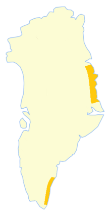
King Frederick VI Coast is a major geographic division of Greenland. It comprises the coastal area of Southeastern Greenland in Sermersooq and Kujalleq municipalities fronting the Irminger Sea of the North Atlantic Ocean. It is bordered by King Christian IX Land on the north and the Greenland Ice Sheet to the west.

Thorland is a peninsula in the King Frederick VI Coast, southeastern Greenland. It is a part of the Sermersooq municipality.

<span class="mw-page-title-main">Fridtjof Nansen Land</span> Former Norwegian territory in Greenland

Fridtjof Nansen Land was a suggested but not officially adopted Norwegian name of a territory on the southern East Coast of Greenland, that was proclaimed by Norway on July 12, 1932, and occupied until April 5, 1933. It was named after Norwegian polar explorer Fridtjof Nansen. The short-lived territory occupied much of King Frederick VI Coast, which had been claimed a century before by the Danish crown.

Nanuuseq Fjord, old spelling Nanûseq, is a fjord in the King Frederick VI Coast, Kujalleq municipality, southern Greenland.

1932–33 East Greenland expedition Pan Am-financed Arctic exploration mission

The 1932–33 East Greenland Expedition, sub-titled the Pan Am expedition by some sources, was a small expedition to Greenland led by Henry "Gino" Watkins until his death and then by John Rymill. The expedition was intended to continue the work of the previous British Arctic Air Route Expedition (BAARE) that had mapped unexplored sections of Greenland in 1930–1931.

<span class="mw-page-title-main">Denmark expedition</span>

The Denmark expedition, also known as the Denmark Expedition to Greenland's Northeast Coast, and as the Danmark Expedition after the ship, was an expedition to the northeast of Greenland in 1906–1908.

<span class="mw-page-title-main">Mørkefjord</span> Body of water

Mørkefjord, meaning in Danish "The dark fjord," is a fjord in King Frederick VIII Land, northeastern Greenland.

Antarctic Haven Body of water

Antarctic Haven is a bay in King Christian X Land, Northeastern Greenland.

Jonsbu Place in Greenland, Denmark

Jonsbu was a Norwegian hunting and radio station located on the coast of Eastern Greenland in present-day King Christian X Land.

Torgils Orrabeinfostre is the Viking hero of Flóamanna saga.

Torgilsbu Place in Greenland, Denmark

Torgilsbu was a Norwegian hunting, meteorological and radio station located on the King Frederick VI Coast, Southeastern Greenland.

Storfjord Station Place in Greenland, Denmark

Storfjord was a Norwegian hunting, meteorological and radio station ("Storfjord/LMR") located in King Christian IX Land, Eastern Greenland.

Graah Fjord, also known as Devold Fjord and Langenæs Fjord, is a fjord in King Frederick VI Coast, eastern Greenland.

Hallvard Devold

Hallvard Ophuus Devold was a Norwegian Arctic explorer, trapper and meteorologist. He was instrumental in the attempt to establish Eric the Red's Land in 1931. His brother Finn Devold (1902–1977) shared his vision and helped to establish a Norwegian station at Finnsbu, SE Greenland.

Finn Devold

Finn Devold was a Norwegian Arctic explorer, marine biologist and meteorologist. His father was parish priest Harald Ophus Devold. Together with his brother Hallvard Devold, Finn shared an interest in the Arctic areas and in the expansion of Norwegian sovereignty across Greenland.

References

  1. 'Jan S. Krogh.Nęrmere beskrivelse av kystradiostasjonene
  2. "Finnsbu". Mapcarta. Retrieved 7 September 2019.
  3. Prostar Sailing Directions 2005 Greenland and Iceland Enroute, p. 102
  4. 1 2 3 Spencer Apollonio, Lands That Hold One Spellbound: A Story of East Greenland, 2008, pp. 188-189
  5. 1 2 3 4 Recent Norwegian Expeditions to Southeast-Greenland, Gunnar Horn
  6. Norwegian Expedition to South-East Greenland, 1932
  7. William James Mills, Exploring Polar Frontiers: A Historical Encyclopedia, p. 321
  8. Finnsbu, Greenland Tide Station Location Guide