
Durham is a cathedral city and civil parish in the county of Durham, England. It is the county town and contains the headquarters of Durham County Council, the unitary authority which governs the district of County Durham. The built-up area had a population of 50,510 at the 2021 Census.

Willington is a village and former civil parish, now in the parish of Greater Willington, in County Durham and the ceremonial county of Durham, England. Willington stands in the foothills of the Pennines and near the River Wear close to Crook, Bishop Auckland and Durham.

Bishop Auckland is a market town and civil parish at the confluence of the River Wear and the River Gaunless in County Durham, England. It is 12 miles (19 km) northwest of Darlington and 12 miles (19 km) southwest of Durham.

County Durham, officially simply Durham (/ˈdʌrəm/), is a ceremonial county in North East England. The county borders Northumberland and Tyne and Wear to the north, the North Sea to the east, North Yorkshire to the south, and Cumbria to the west. The largest settlement is Darlington.

Wear Valley was, from 1974 to 2009, a local government district in County Durham, England. Its council and district capital was Crook.

Lanehead is a hamlet in the civil parish of Stanhope, in County Durham, England. It lies at the head of Weardale, approximately 2 km west of Cowshill. It is also located near to Killhope, and the boundary of the county of Cumbria. In the 2001 census Lanehead had a population of 40.

Billy Row is a village in County Durham, England. It is situated a short distance to the north of Crook. According to the 2001 census Billy Row has a population of 824.
Toronto is a village in County Durham, England. It is situated a mile to the north-west of Bishop Auckland and was represented in Wear Valley District Council until that authority was merged into Durham County Council in April 2009. In the 2001 census Toronto had a population of 399.

Tow Law is a town and civil parish in County Durham, England. It is situated a few miles to the south of Consett and 5 miles to the north west of Crook.
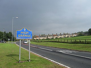
High Grange is a village in County Durham, in England. It is situated on the A689 between Bishop Auckland and Crook.

Howden-le-Wear is a village in County Durham, in England. Howden-le-Wear is approximately 1 mile south of the large market town of Crook. It has a number of shops including the village One Stop convenience store, hairdressers, butchers and the petrol station. The 2011 Census reported that Howden has a population of 1,535.
St John's Chapel is a village in the civil parish of Stanhope, in County Durham, England. It is situated in Weardale, on the south side of the River Wear on the A689 road between Daddry Shield and Ireshopeburn. The 2001 census reported a population of 307.

Leeholme is a village in County Durham, England. It is situated immediately to the north of Coundon. In the 2001 census Leeholme had a population of 513.

Helmington Row is a small village in County Durham, England. It is situated between Crook and Willington, about 7 miles south-west of Durham and 3 miles north-north-west of Bishop Auckland.
Roddymoor is a village in County Durham, in England. In the 2001 census Roddymoor had a population of 500.

Stanhope is a market town and civil parish in the County Durham district, in the ceremonial county of Durham, England. It lies on the River Wear between Eastgate and Frosterley, in the north-east of Weardale. The main A689 road over the Pennines is crossed by the B6278 between Barnard Castle and Shotley Bridge. In 2001 Stanhope had a population of 1,633, in 2019 an estimate of 1,627, and a figure of 1,602 in the 2011 census for the ONS built-up-area which includes Crawleyside. In 2011 the parish population was 4,581.

Stanley Crook is a village in County Durham, in England. It is situated to the north of Crook and Billy Row. The area is rural, surrounded by open farm land and woodland. There are several farms and many small holdings. It is a small former mining village which used to have two collieries. During the 1970s, the village was classified as category D, which meant the council wished to demolish the whole village. However, this did not happen, only 3 streets were demolished. In the 2001 census Stanley Crook had a population of 405.

Bishop Auckland is a constituency in County Durham that is represented in the House of Commons since 2024 by Sam Rushworth of the Labour Party.
Bradbury is a village in the County Durham district, in the ceremonial county of Durham, England. It is situated between Sedgefield and Newton Aycliffe, close to the A1(M) and A689, and is approximately 16 km (9.9 mi) from Middlesbrough. Bradbury is a small agricultural village. The moorland around it is of glacial origin.

County Durham is a unitary authority area in the ceremonial county of County Durham, England. It is governed by Durham County Council. The district has an area of 2,226 square kilometres (859 sq mi), and contains 135 civil parishes. It forms part of the larger ceremonial county of Durham, together with boroughs of Darlington, Hartlepool, and the part of Stockton-on-Tees north of the River Tees.
