Florence Regional Airport

Last updated

Florence Regional Airport

(former Florence Army Airfield)
Florence Regional Airport (logo).png
Florence Regional Airport - South Carolina.jpg
Summary
Airport typePublic
OwnerPee Dee Regional Airport Authority
Serves Florence, South Carolina
Location Florence County, near Florence, South Carolina
Elevation  AMSL 146 ft / 45 m
Coordinates 34°11′07″N079°43′26″W / 34.18528°N 79.72389°W / 34.18528; -79.72389
Website www.flyflo.us
Map
USA South Carolina relief location map.svg
Airplane silhouette.svg
FLO
Usa edcp relief location map.png
Airplane silhouette.svg
FLO
Runways
Direction LengthSurface
ftm
1/196,0001,829 Asphalt
9/276,5021,982Asphalt
Statistics (2022)
Aircraft operations (year ending 2/22/2022)23,572
Based aircraft47
Sources: airport website [1] and FAA [2]

Florence Regional Airport( IATA : FLO, ICAO : KFLO, FAA LID : FLO) is three miles east of Florence, in Florence County, South Carolina. [2]

Contents

The only scheduled flights are American Eagle to Charlotte-Douglas International Airport.

Facilities

The airport covers 1,436 acres (581 ha) and has two asphalt runways: 1/19 is 6,000 × 150 ft (1,829 × 46 m) and 9/27 is 6,502 × 150 ft (1,982 × 46 m). [2]

In the year ending February 22, 2022, the airport had 23,572 aircraft operations, average 65 per day: 84% general aviation, 11% air taxi, 6% military, and <1% commercial. 47 aircraft were then based at the airport: 25% single-engine, 14 multi-engine, 2 jet, and 6 helicopters. [2]

Airline and destination

AirlinesDestinations
American Eagle Charlotte [3]

Destination statistics

Busiest domestic routes from Florence
(November 2021 – October 2022)
[4]
RankCityPassengers
1 Charlotte, North Carolina 31,000

History

The airport began with the purchase of 300 acres (120 ha) in 1928. During World War II the United States Army Air Forces' Third Air Force used the airport as a training base and added 1,400 acres (570 ha). Known as Florence Army Airfield, the 52d Pursuit Group was assigned to the airfield on 18 February 1942 and trained with P-39 Airacobra and P-40 Warhawks until departing on 27 April for Wilmington, North Carolina.

A succession of Troop Carrier groups trained at Florence during 1943 those being the 63d, 65th, 313th and 315th prior to their deployment to Europe and North Africa. The airfield became a combat crew replacement training school for A-20 Havoc light bomber crews, with the 411th Bombardment Group being the Operational Training Unit at Florence AAF from 15 August 1943 until 1 May 1944.

After the 344th was inactivated, replacement training was taken over by the 334th Army Air Forces Base Unit (Replacement Training Unit, Light Bombardment). Support units at Florence AAF were the 407th Base Headquarters and Air Base Squadron; 10th Aviation Squadron; 958th Guard Squadron; 341st Sub-Depot; HQ, 411th Bombardment Group (Light).

Florence AAF controlled two auxiliary training bases for its A-20 training.

In early 1945 the airfield was transferred to First Air Force and the 127th Army Air Forces Base unit (Combat Crew Training Station, Light) assumed the A-26 Invader training mission.

The property was given back to the City of Florence on 31 October 1945 and later shared with Florence County. [1]

Eastern Airlines served FLO from 1948 to 1965; Piedmont Airlines flights (including Boeing 737s) ended in 1981.

Operation of the airport was assigned to the Pee Dee Regional Airport Authority in 1999. The authority had nine representatives from the Pee Dee Regional Airport District, which includes the City of Florence, and the counties of Florence, Dillon and Marion. [1]

Florence Air & Missile Museum

From the 1960s until 1997 Florence was home to a large aviation museum, the Florence Air & Missile Museum. When it closed, the collection was divided among other museums in the United States.

See also

Related Research Articles

<span class="mw-page-title-main">Hunter Army Airfield</span> Military airfield near Hinesville, Georgia, US

Hunter Army Airfield, located in Savannah, Georgia, United States, is a military airfield and subordinate installation to Fort Stewart located in Hinesville, Georgia.

<span class="mw-page-title-main">McEntire Joint National Guard Base</span> Military airport in Richland County, SC, US

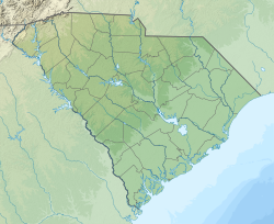
McEntire Joint National Guard Base or McEntire JNGB is a military airport located in Richland County, South Carolina, United States, 10 miles (16 km) west of the town of Eastover and approximately 15 miles southeast of the city of Columbia. It is owned by the U.S. Air Force affiliated with the South Carolina Air National Guard (SCANG).

<span class="mw-page-title-main">Redding Regional Airport</span> Municipal airport serving the city of Redding in Shasta County, California, United States

Redding Regional Airport is 6 miles (10 km) southeast of Redding in Shasta County, California, United States. It is one of two airports in Redding, along with Benton Airpark. In addition to general aviation, the airport has scheduled passenger flights nonstop to and from Burbank (BUR) on Avelo Airlines Boeing 737s, Los Angeles (LAX) and San Francisco (SFO) on United Express Canadair CRJ200, CRJ700 and Embraer 175 regional jets, and Alaska Airlines Embraer 175 service to Seattle (SEA).

<span class="mw-page-title-main">Salinas Municipal Airport</span> Municipal airport in Salinas, California, United States

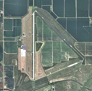
Salinas Municipal Airport, commonly referred to as Salinas Airport is an airport in Monterey County, California, United States, three miles (4.8 km) southeast of Downtown Salinas. It is included in the 2017–21 National Plan of Integrated Airport Systems as a regional general aviation airport. It had 1,800 enplanements in 2014.

<span class="mw-page-title-main">Reading Regional Airport</span> Airport in Pennsylvania

Reading Regional Airport, also known as Carl A. Spaatz Field, is a public airport three miles (5 km) northwest of Reading, in Bern Township, Berks County, Pennsylvania. It is owned by the Reading Regional Airport Authority.

<span class="mw-page-title-main">Blythe Airport</span> Airport

Blythe Airport is seven miles west of Blythe, in Riverside County, California, United States. The National Plan of Integrated Airport Systems for 2011–2015 categorized it as a general aviation facility.

<span class="mw-page-title-main">Ainsworth Regional Airport</span> Airport

Ainsworth Regional Airport is seven miles northwest of Ainsworth, in Brown County, Nebraska. It is owned by the Ainsworth Airport Authority. The National Plan of Integrated Airport Systems for 2011–2015 called it a general aviation airport.

<span class="mw-page-title-main">Fairmont State Airfield</span> Airport in Madison Township, Fillmore County

Fairmont State Airfield is three miles south of Fairmont, in Fillmore County, Nebraska. The National Plan of Integrated Airport Systems for 2011–2015 categorized it as a general aviation facility. It has no scheduled airline service.

<span class="mw-page-title-main">Harvard State Airport</span> Airport in near Harvard, Nebraska

Harvard State Airport is two miles northeast of Harvard, in Clay County, Nebraska. It has no airline flights.

<span class="mw-page-title-main">Waycross–Ware County Airport</span> Airport in near Waycross, Georgia

Waycross–Ware County Airport is four miles northwest of Waycross, in Ware County, Georgia. It is owned by the City of Waycross and Ware County.

<span class="mw-page-title-main">Brooksville–Tampa Bay Regional Airport</span> Airport in near Brooksville, Florida

Brooksville–Tampa Bay Regional Airport, formerly known as Hernando County Airport, is a joint civil-military public airport located 6 nautical miles (11 km) southwest of the central business district of Brooksville, a city in Hernando County, Florida, United States. It is owned by Hernando County and is 45 miles (72 km) north of Tampa. While having consistent growth in its traffic rate, it does not yet serve the public through commercial airlines, but it does have charter and executive service.

<span class="mw-page-title-main">Daniel Field</span> Airport

Daniel Field is a public use airport located one nautical mile (2 km) west of the central business district of Augusta, a city in Richmond County, Georgia, United States. It is owned by the City of Augusta and operated by the General Aviation Commission. This airport is included in the National Plan of Integrated Airport Systems for 2021–2025, which categorized it as a general aviation facility.

<span class="mw-page-title-main">Perry–Foley Airport</span> Airport in Taylor County, Florida

Perry–Foley Airport is a public-use airport located 3 miles (4.8 km) south of the central business district of the city of Perry in Taylor County, Florida, United States. The airport is publicly owned.

<span class="mw-page-title-main">Macon Downtown Airport</span> Airport

Macon Downtown Airport is a city-owned public-use airport located three nautical miles southeast of the central business district of Macon, in Bibb County, Georgia, United States. It is also known as Herbert Smart Downtown Airport. The airport is included in the FAA's National Plan of Integrated Airport Systems for 2011–2015, which categorized it as a general aviation facility. It has no scheduled commercial airline service.

<span class="mw-page-title-main">Lowcountry Regional Airport</span> Airport in Colleton County, South Carolina

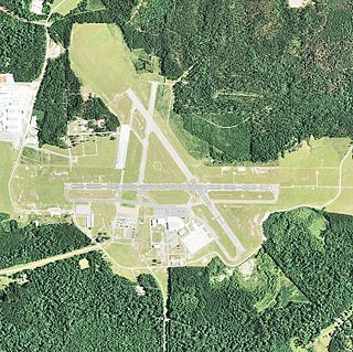
Lowcountry Regional Airport is a public use airport located two nautical miles (4 km) northeast of the central business district of Walterboro, a city in Colleton County, South Carolina, United States. It is owned by the city and county. This airport is included in the National Plan of Integrated Airport Systems for 2011–2015, which categorized it as a general aviation facility. It does not have scheduled commercial airline service.

<span class="mw-page-title-main">Darlington County Airport</span> Airport in South Carolina

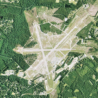
Darlington County Airport (Jetport) (ICAO: KUDG, FAA LID: UDG) is a county-owned, public-use airport located nine nautical miles (10 mi, 17 km) north of the central business district of Darlington, a city in Darlington County, South Carolina, United States. It is included in the National Plan of Integrated Airport Systems for 2011–2015, which categorized it as a general aviation facility. The airport does not have scheduled commercial airline service.

<span class="mw-page-title-main">Esler Airfield</span> Airport in Rapides Parish, Louisiana

Esler Field, also known as Esler Regional Airport, is a military and public use airfield in Rapides Parish, Louisiana, United States, near the City of Pineville. It is located 10 nautical miles northeast of the central business district of Alexandria, Louisiana, The airfield is owned by the Louisiana Army National Guard and is the home of Army Aviation Support Facility #2 (AASF#2).

<span class="mw-page-title-main">Hesler-Noble Field</span> Airport in Jones County, Mississippi

Hesler-Noble Field is a public airport in Jones County, Mississippi. It is owned by Laurel Airport Authority and is three miles southwest of Laurel, Mississippi.

<span class="mw-page-title-main">Hattiesburg Bobby L. Chain Municipal Airport</span> Airport in Forrest County, Mississippi

Hattiesburg Bobby L. Chain Municipal Airport in Forrest County, Mississippi is owned by the City of Hattiesburg and is five miles southeast of downtown.

<span class="mw-page-title-main">Grand Island Army Air Field</span> Operating 1942 to 1946

Grand Island Army Airfield was a United States Army Air Forces airfield which operated from 1942 to 1946. After its closure, the base was reopened as Central Nebraska Regional Airport.

References

PD-icon.svg This article incorporates public domain material from the Air Force Historical Research Agency

  1. 1 2 3 Florence Regional Airport, official site
  2. 1 2 3 4 FAA Airport Form 5010 for FLO PDF , effective 13 July 2023
  3. "American Airlines Suspends Service to 15 Markets in October as CARES Act Service Commitment Expires". American Airlines Newsroom. Archived from the original on 20 August 2020. Retrieved 20 August 2020.
  4. "RITA | BTS | Transtats". Bureau of Transportation Statistics. January 2017. Retrieved 15 May 2017.