Roxbury is a community on the Rockaway Peninsula in the New York City borough of Queens. The neighborhood is just west of the Marine Parkway–Gil Hodges Memorial Bridge and adjoins Fort Tilden. It is an inholding within the borders of the Breezy Point Unit of Gateway National Recreation Area, of the US National Park System.

Middlebranch is an unincorporated community in northeastern Plain Township, Stark County, Ohio, United States. Although it is unincorporated, it has a post office, with the ZIP code of 44652. The community is part of the Canton–Massillon Metropolitan Statistical Area. The area is mostly residential, with notable amounts of land being used for farming as well. Trains from the Wheeling and Lake Erie Railway often run through the area carrying loads of scrap metal bound for other Ohio cities.

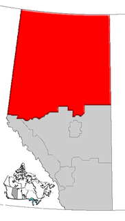
Beauvallon is a hamlet in central Alberta, Canada within the County of Two Hills No. 21. It is located on Highway 45, approximately 139 kilometres (86 mi) east of Edmonton.
Brosseau is a hamlet in central Alberta, Canada within the County of Two Hills No. 21. It is located on the north bank of the North Saskatchewan River along the Highway 29 / Highway 36 concurrency, 50 km (31 mi) southwest of St. Paul. The hamlet of Duvernay is located immediately across the river along the south bank.
Duvernay is a hamlet in central Alberta, Canada within the County of Two Hills No. 21. It is located 1.6 km (1.0 mi) north of the intersection of Highway 36 and Highway 29 along the south bank of the North Saskatchewan River, approximately 53 km (33 mi) southwest of St. Paul. The hamlet of Brosseau is located immediately across the river along the north bank.
Hairy Hill is a hamlet in Alberta, Canada within the County of Two Hills No. 21. It is located on Highway 45, approximately 102 kilometres (63 mi) east of Edmonton.
Lafond is a hamlet in northern Alberta, Canada within the County of St. Paul No. 19. It is located 5 kilometres (3.1 mi) east of Highway 36, approximately 117 kilometres (73 mi) northwest of Lloydminster.
Lavoy is a hamlet in central Alberta, Canada within the County of Minburn No. 27. It is located on Highway 16, approximately 108 kilometres (67 mi) east of Edmonton.
Morecambe is a hamlet in central Alberta, Canada within the County of Two Hills No. 21. It is located 0.5 kilometres (0.31 mi) south of Highway 45, approximately 104 kilometres (65 mi) northwest of Lloydminster.
Musidora is a hamlet in central Alberta, Canada within the County of Two Hills No. 21. It is located on Highway 45, approximately 112 kilometres (70 mi) northwest of Lloydminster.
St. Edouard is a hamlet in northern Alberta, Canada within the County of St. Paul No. 19. It is located 2 kilometres (1.2 mi) south of Highway 28, approximately 82 kilometres (51 mi) southwest of Cold Lake.
St. Lina or Ste-Lina in French, is a hamlet in northern Alberta, Canada within the County of St. Paul No. 19. It is home of St. Lina Community Hall. It is located approximately 14 kilometres (8.7 mi) north of Highway 28 and 85 kilometres (53 mi) southwest of Cold Lake.
Sunnynook is a hamlet in southern Alberta, Canada within Special Area No. 2. It is located approximately 10 kilometres (6.2 mi) east of Highway 36 and 86 kilometres (53 mi) northeast of Brooks. The hamlet formerly housed the Berry Creek Community School Division office and area post office until amalgamation of the school division into Prairie Land Regional Division.
Berrytown is an unincorporated community in Bradford County, Pennsylvania, United States. Its elevation is 1672 ft (479 m), and it is located at 41°53′24″N76°46′01″W.
Golfland Entertainment Centers are a chain of family amusement centers, miniature golf courses, and water parks located in California and Arizona. The company was founded in 1953.
Tobacco is an unincorporated community located in Brunswick County, in the U.S. state of Virginia.

Timon is an unincorporated community in Natchitoches Parish, Louisiana, United States.

South Richmond is an unincorporated community in Wayne Township, Wayne County, in the U.S. state of Indiana.
Lotus is an unincorporated community in Center Township, Union County, in the U.S. state of Indiana.
Boles is an unincorporated community in Franklin County, in the U.S. state of Missouri.