
Carcoar is a small town in the Central West region of New South Wales, Australia, in Blayney Shire. In 2016, the town had a population of 200 people. It is situated just off the Mid-Western Highway 258 km west of Sydney and 52 km south-west of Bathurst and is 720 m above sea level. It is located in a small green valley, with the township and buildings on both banks of the Belubula River. It is the third oldest settlement west of the Blue Mountains. Carcoar is a Gundungurra word meaning either 'frog' or 'kookaburra'. Nearby towns are Blayney, Millthorpe, Mandurama, Neville, Lyndhurst and Barry

Tooma is a locality and village community in the Snowy Valleys Council local government area, in the eastern part of the Riverina region of New South Wales.

Book Book is a rural community in the central east part of the Riverina. It is situated about 12 km (7 mi) north of Kyeamba and 15 km (9 mi) south of Ladysmith.
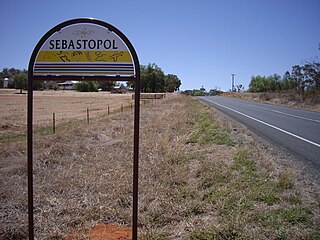
Sebastopol is a village community in the north east part of the Riverina, in New South Wales, Australia. It is situated about 15 kilometres south of Temora and 19 kilometres north of Junee Reefs.
Burraga is located in the Central Tablelands of New South Wales, 47 kilometres south west of Oberon and about 67 kilometres (42 mi) south of Bathurst. It is within Oberon Shire. At the 2016 census, Burraga had a population of 91.

Currawang is a rural locality, located to the north of Lake George. in New South Wales, Australia. It lies on the intersection between three councils, with the majority straddling the boundary between the Queanbeyan–Palerang Regional Council and Goulburn-Mulwaree Council and a small portion of the locality in the Upper Lachlan Shire. It shares its name with the Currawang Parish of Argyle County, in which it is located. This was formerly known as the parish of Currowang. Both names derive from an Aboriginal word for the spearwood tree.
Gubbata is a locality in the Central West region of New South Wales. The locality is in the Bland Shire local government area 432 kilometres (268 mi) west of the state capital, Sydney.
Frogmore is a village in the Southern Tablelands of New South Wales, Australia. It was previously a mining town.

Colinton is a locality in the Snowy Monaro Region, New South Wales, Australia. At the 2016 census, it had a population of 127. There was once a village and railway station of the same name.

Bunyan is a locality in the Snowy Monaro Region, New South Wales, Australia. It lies on the eastern side of the Murrumbidgee River and on both sides of the Monaro Highway about 110 km south of Canberra and about 10 km north of Cooma. At the 2016 census, it had a population of 152.
Numeralla, is a village in Snowy Monaro Region of New South Wales, Australia. The name is also applied to the surrounding area, for postal and statistical purposes. In 2016, the population of the village and its surrounding area was 258. The village was known as Umaralla until 1972.
Caloola is a locality in the Central West region of New South Wales. There once was a small village of the same name but it is a ghost town today. At the 2016 census, the locality had a population of 88.
Currowan is a locality in the Eurobodalla Shire, on the South Coast of New South Wales, Australia. At the 2016 census, it had a population of 53.
Dalmorton is a locality in the Northern Rivers region of New South Wales, Australia. There once was a village of the same name, which was associated with gold mining. Much of the area of the locality is now reserved as National Parks or State Forests. At the 2016 census, the population of Dalmorton was four.
Cunningar is a locality in the Hilltops Council local government area, within the South West Slopes region of New South Wales, Australia. It is located immediately to the east of the town of Harden. There is a parish of the County of Harden of the same name, which comprises a part of the area of the locality.
Rock Flat is a rural locality in the Snowy Monaro Regional Council local government area of New South Wales, Australia. It is located south of Cooma, on either side of the Monaro Highway.

North Yalgogrin is a locality in the Bland Shire local government area of New South Wales. There once was a village there, named Yalgogrin, but better known as Yalgogrin North.
Miandetta is a locality in the Bogan Shire, within the Orana region, of New South Wales, Australia. There was once a small settlement, also known as Miandetta. The locality had a population of 23, in 2021.
Dangelong is a rural locality in the Snowy Monaro Regional Council local government area of New South Wales, Australia. It is located south-east of Cooma. It had no people or a very low population recorded at the 2021 census.
Lidsdale is a locality within the City of Lithgow Local Government Area of New South Wales, Australia. It lies to the north of Wallerawang. Its area, as defined for postal and statistical purposes, includes the historic locality of Kerosene Vale and the small rural areas known as Springvale and Angus Place. In 2021, its population was 471.


