The Potomac River is found within the Mid-Atlantic region of the United States and flows from the Potomac Highlands into the Chesapeake Bay. The river is approximately 405 miles (652 km) long, with a drainage area of about 14,700 square miles (38,000 km2). In terms of area, this makes the Potomac River the fourth largest river along the East Coast of the United States and the 21st largest in the United States. Over 5 million people live within the Potomac watershed.

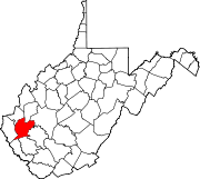
Wyoming County is a county in the U.S. state of West Virginia. As of the 2010 census, the population was 23,796. Its county seat is Pineville. The county was created in 1850 from Logan County and named for the Delaware Indian word meaning "large plains".

The South Branch Potomac River has its headwaters in northwestern Highland County, Virginia near Hightown along the eastern edge of the Allegheny Front. After a river distance of 139 miles (224 km), the mouth of the South Branch lies east of Green Spring in Hampshire County, West Virginia where it meets the North Branch Potomac River to form the Potomac.

West Virginia Route 28 is a north–south route through the Potomac Highlands of the U.S. state of West Virginia. The southern terminus of the route is at West Virginia Route 39 in Huntersville. The northern terminus is at the Maryland state line in Wiley Ford, where the route continues into Cumberland as Canal Parkway upon crossing the North Branch Potomac River.

State Route 127 is a primary state highway in the U.S. state of Virginia. The state highway begins at the West Virginia state line at Good, West Virginia, where the highway continues west as West Virginia Route 127. SR 127 heads east 3.55 miles (5.71 km) to U.S. Route 522 near Cross Junction in northwestern Frederick County. SR 127 is the easternmost portion of Bloomery Pike, a turnpike that connected Winchester with the namesake iron smelting center.
West Virginia Route 971 is a 9.9-mile (15.9 km) north–south state highway in Wyoming County, West Virginia. The route runs from West Virginia Route 97 in Baileysville north to West Virginia Route 10 in Oceana. It runs through mountainous, rural terrain, connecting Baileysville and Oceana to the communities of Clear Fork, Lillydale, and Lillyhaven. WV 971 has been the highest numbered state highway in West Virginia since July 2017, when WV 972 was decommissioned and absorbed by WV 93.

Stotlers Crossroads is a small unincorporated community hamlet in southeastern Morgan County, West Virginia. It is situated along Winchester Grade Road between the South and Middle Forks of Sleepy Creek on the eastern flanks of Highland Ridge.

U.S. Route 50 in West Virginia runs from the border with Ohio to Virginia, passing briefly through Garrett County, Maryland, and following the Northwestern Turnpike. Prior to the U.S. Highway System it was West Virginia Route 1 and in the 1930s, the road was not finished in Maryland. Today the section of US 50 from Clarksburg to Parkersburg on the Ohio River is part of Corridor D of the Appalachian Development Highway System.

Seneca Creek is a 19.6-mile-long (31.5 km) tributary of the North Fork of the South Branch of the Potomac River located entirely within Pendleton County, West Virginia, USA.

State Route 80 is a primary state highway in the southwest part of the U.S. state of Virginia. It runs from the Kentucky state line at Breaks Interstate Park east to U.S. Route 11 near Meadowview. Kentucky Route 80 and Missouri's Route 80 continue the number west to Matthews, Missouri.
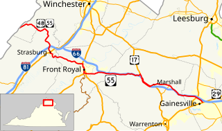
State Route 55 is a primary state highway in the U.S. state of Virginia. Known for most of its length as John Marshall Highway, the state highway runs 64.71 miles (104.14 km) from the West Virginia state line, where the highway continues as West Virginia Route 55, east to U.S. Route 29 in Gainesville. West of its interchange with Interstate 81 (I-81) in Strasburg, SR 55 runs concurrently with the easternmost portion of US 48 as part of Corridor H. East of Front Royal, the state highway serves as the local complement of I-66 as it passes through the towns of Marshall, The Plains, and Haymarket.
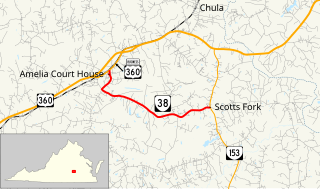
State Route 38 is a primary state highway in the U.S. state of Virginia. Known for most of its length as Five Forks Road, the state highway runs 7.03 miles (11.31 km) from U.S. Route 360 Business in Amelia Court House east to SR 153 at Scotts Fork.
Clear Fork may refer to a location in the United States:
Four Mile Fork is an unincorporated community in Spotsylvania County, Virginia south of the city limits of Fredericksburg. Its name derives from the junction of State Route 208, U.S. Route 1, and U.S. Route 1 Business, which is located approximately four miles south of downtown Fredericksburg.
Cohasset is an unincorporated community in Fluvanna County, in the U.S. state of Virginia located about two miles west of Fork Union on State Route 6.

Judy Gap is an unincorporated community in Pendleton County, West Virginia, United States. Judy Gap is located at the junction of U.S. Route 33 and West Virginia Route 28 8.5 miles (13.7 km) west-northwest of Franklin, just west of the mountain gap also called Judy Gap. The Judy Rocks geological formation is just to the south. North Fork Mountain is to the east, and the North Fork of the South Branch of the Potomac River is to the west, with Spruce Mountain and Spruce Knob beyond the river. Most of the surrounding land is within the Monongahela National Forest.
Liverpool is an unincorporated community in Jackson and Roane counties, West Virginia, United States. Liverpool is located along the Right Fork Sandy Creek at the junction of Jackson County Route 13 and Roane County Route 1, 5.7 miles (9.2 km) west of Reedy Liverpool had a post office, which closed on May 30, 1989. The community was named after Liverpool, in England.
Clear Fork Junction is an unincorporated community in McDowell County, West Virginia.

Forks of Waters is an unincorporated community located in Highland County, Virginia, United States. Forks of Waters is located approximately 6 miles (9.7 km) northeast of Monterey, Virginia at the junction of U.S. Route 220 and Virginia State Route 642. Forks of Waters is so named due to the convergence of the Strait Creek with the South Branch Potomac River near the community. After passing through Forks of Waters, the South Branch Potomac River enters West Virginia approximately 1 mile (1.6 km) to the northeast.