
Newport is a city in and the county seat of Cocke County, Tennessee, United States. The population was 6,945 at the 2010 census, down from 7,242 at the 2000 census. The estimated population in 2018 was 6,801. Newport is located along the Pigeon River.
Fort Ashby is a census-designated place (CDP) in Mineral County, West Virginia, United States, along Patterson Creek. It is part of the Cumberland, MD-WV Metropolitan Statistical Area. The population was 1,380 at the 2010 census. The community was originally chartered as Frankfort and then known as Alaska before it took the name of its well-known historic landmark. Fort Ashby is the location of the Mineral County Fair.

Aztalan State Park is a Wisconsin state park in the Town of Aztalan, Jefferson County. Established in 1952, it was designated a National Historic Landmark in 1964 and added to the National Register of Historic Places in 1966. The park covers 172 acres (70 ha) along the Crawfish River.

Fort Ashby is a historic stockade fort located in Fort Ashby, West Virginia, US. A military installation constructed during the French and Indian War, it is listed on the National Register of Historic Places.
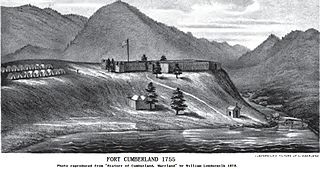
Fort Cumberland was an 18th-century frontier fort at the current site of Cumberland, Maryland, USA. It was an important military and economic center during the French and Indian War (1754–63) and figured significantly in the early career of George Washington.
Headsville is an unincorporated community in Mineral County, West Virginia, United States. It is part of the Cumberland, MD-WV Metropolitan Statistical Area. It lies between U.S. Route 50 and West Virginia Route 46 alongside Pattersons Creek.
Fort Ohio was a stockade fort erected by Job Pearsall in 1749 on the present site of Ridgeley, West Virginia. The building was of log construction, 45 feet (14 m) long and 25 feet (7.6 m) wide, with two stories. Its name comes from the Ohio Company which did have a trading post at that location. The Ohio Company found success because a trail across the Allegheny Mountains from the Potomac River at Cumberland to near modern-day Pittsburgh offered a direct route to the Ohio River.
New Creek Blockhouse, was built about 1 mile west of New Creek to protect local settlers in 1750. The fortification consisted of a log blockhouse but without a stockade around it.
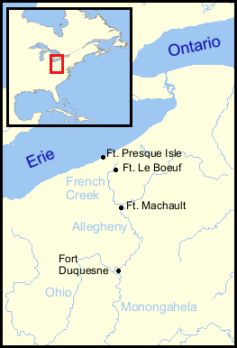
Fort Machault was a fort built by the French in 1754 near the confluence of French Creek with the Allegheny River, in northwest Pennsylvania. The fort helped the French control these waterways, part of what was known as the Venango Path from Lake Erie to the Ohio River.
Fort Sellers was a small stockade on the east side of Pattersons Creek at the confluence with the Potomac River, in Franklin District, in present-day Mineral County, West Virginia. The fort was erected by Colonel Washington.

Ridgedale is a 19th-century Greek Revival plantation house and farm on a plateau overlooking the South Branch Potomac River north of Romney, West Virginia, United States. The populated area adjacent to Washington Bottom Farm is known as Ridgedale. The farm is connected to West Virginia Route 28 via Washington Bottom Road.

The Stockade Historic District is located in the northwest corner of Schenectady, New York, United States, on the banks of the Mohawk River. It is the oldest neighborhood in the city, continuously inhabited for over 300 years. Union College first held classes in a building within the district, and later it would be one of the termini of an early suspension bridge that was, at the time, the longest in North America. Joseph C. Yates, the 7th Governor of New York and founding trustee of Union College, and Elizabeth V. Gillette, a physician and the first woman from upstate New York elected to the New York State Assembly, were residents of the Stockade.

Fort Strother was a stockade fort at Ten Islands in the Mississippi Territory, in what is today St. Clair County, Alabama. It was located on a bluff of the Coosa River, near the modern Neely Henry Dam in Ragland, Alabama. The fort was built by General Andrew Jackson and several thousand militiamen in November 1813, during the Creek War and was named for Captain John Strother, Jackson's chief cartographer.
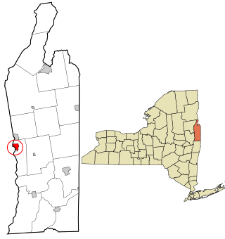
Fort Edward is a village in Washington County, New York, United States. It is part of the Glens Falls Metropolitan Statistical Area. The village population was 3,375 at the 2010 census. The name is derived from the younger brother of King George III, Edward Augustus, Duke of York and Albany.
Patterson Creek is a 51.2-mile-long (82.4 km) tributary of the North Branch Potomac River in West Virginia's Eastern Panhandle, in the United States. It enters the North Branch east of Cumberland, Maryland, with its headwaters located in Grant County, West Virginia. Patterson Creek is the watershed for two-thirds of Mineral County, West Virginia. The creek passes through Lahmansville, Forman, Medley, Williamsport, Burlington, Headsville, Reeses Mill, Champwood, and Fort Ashby.

Clover Creek is an unincorporated community in Highland County, Virginia, United States. Clover Creek is located 10 miles (16 km) south-southeast of Monterey, Virginia, on State Route 678. The community is situated in the Bullpasture Valley along the path of the Bullpasture River. Beginning in 1897 with a decision by the United States Board on Geographic Names, the community was officially referred to as the single-word "Clovercreek"; however, in 1970, the board modified the community's name to the current two-word "Clover Creek". During the French and Indian War, a British fort named Fort George was built near Clover Creek in 1754 consisting of a wooden stockade 90 feet (27 m) square. The fort was never directly attacked, though arrows were at one point launched against the fort from a distance leaving no damage. George Washington may have visited the fort while traveling in the area, marking the only time Washington visited the region which is now known as Highland County.
Fort Armstrong was a stockade fort built in present-day Cherokee County, Alabama during the Creek War. The fort was built to protect the surrounding area from attacks by Red Stick warriors but was also used as a staging area and supply depot in preparation for further military action against the Red Sticks.

Fort Leslie was a stockade fort built in present-day Talladega County, Alabama, in 1813 during the Creek War. After the Creek War began, protective stockades were built by settlers and Creeks who were allied with the United States to protect themselves from hostile Creek attacks. Fort Leslie was the focal point of the Battle of Talladega but was soon abandoned after the end of the Creek War.

Fort Madison was a stockade fort built in August 1813 in present-day Clarke County, Alabama, during the Creek War, which was part of the larger War of 1812. The fort was built by the United States military in response to attacks by Creek warriors on encroaching American settlers. The fort shared many similarities to surrounding stockade forts in its construction but possessed a number of differences in its defenses. The fort housed members of the United States Army and settlers from the surrounding area, and it was used as a staging area for raids on Creek forces and supply point on further military expeditions. Fort Madison was subsequently abandoned at the conclusion of the Creek War and only a historical marker exists at the site today.
Fort Pierce, was two separate stockade forts built in 1813 in present-day Baldwin County, Alabama, during the Creek War, which was part of the larger War of 1812. The fort was originally built by settlers in the Mississippi Territory to protect themselves from attacks by Creek warriors. A new fort of the same name was then built by the United States military in preparation for further action in the War of 1812, but the fort was essentially abandoned within a few years. Nothing exists at the site today.
