
New Amsterdam was a 17th-century Dutch settlement established at the southern tip of Manhattan Island that served as the seat of the colonial government in New Netherland. The initial trading factory gave rise to the settlement around Fort Amsterdam. The fort was situated on the strategic southern tip of the island of Manhattan and was meant to defend the fur trade operations of the Dutch West India Company in the North River. In 1624, it became a provincial extension of the Dutch Republic and was designated as the capital of the province in 1625. New Amsterdam became a city when it received municipal rights on February 2, 1653.

New Netherland was a 17th-century colonial province of the Dutch Republic located on the East Coast of what is now the United States of America. The claimed territories extended from the Delmarva Peninsula to Cape Cod. Settlements were established in what became the states of New York, New Jersey, Delaware, and Connecticut, with small outposts in Pennsylvania and Rhode Island.

The Netherlands began its colonization of the Americas with the establishment of trading posts and plantations, which preceded the much wider known colonization activities of the Dutch in Asia. While the first Dutch fort in Asia was built in 1600 in present-day Indonesia, the first forts and settlements along the Essequibo River in Guyana date from the 1590s. Actual colonization, with the Dutch settling in the new lands, was not as common as by other European nations.
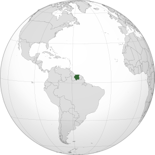
Demerara is a historical region in the Guianas, on the north coast of South America, now part of the country of Guyana. It was a colony of the Dutch West India Company between 1745 and 1792 and a colony of the Dutch state from 1792 until 1815. It was merged with Essequibo in 1812 by the British who took control. It formally became a British colony in 1815 until Demerara-Essequibo was merged with Berbice to form the colony of British Guiana in 1831. In 1838, it became a county of British Guiana until 1958. In 1966, British Guiana gained independence as Guyana and in 1970 it became a republic as the Co-operative Republic of Guyana. It was located around the lower course of the Demerara River, and its main settlement was Georgetown.

New Amsterdam is the regional capital of East Berbice-Corentyne, Guyana and one of the country's largest towns. It is 100 kilometres (62 mi) from the capital, Georgetown and located on the eastern bank of the Berbice River, 6 km (4 mi) upriver from its mouth at the Atlantic Ocean, and immediately south of the Canje River. New Amsterdam's population is 17,329 inhabitants as of 2012.

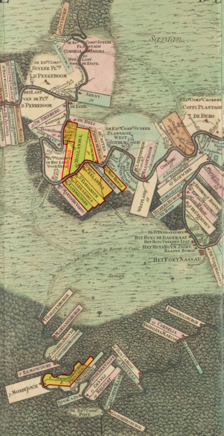
Cuffy, also known as Kofi Badu, also spelled as Coffy, Cuffy, Kofi, or Koffi, was an Akan man who was captured in his native West Africa and stolen for slavery to work on the plantations of the Dutch colony of Berbice in present-day Guyana. In 1763, he led a major slave revolt of more than 3,800 slaves against the colonial regime. Today, he is a national hero in Guyana.

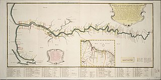
The Berbice River, located in eastern Guyana, is one of the country's major rivers. It rises in the highlands of the Rupununi region and flows northward for 595 kilometres (370 mi) through dense forests to the coastal plain. The river's tidal limit is between 160 and 320 km (99–199 mi) from the sea.

The Guianas, also spelled Guyanas or Guayanas, is a region in north-eastern South America. Strictly, the term refers to the three Guianas: Guyana, Suriname and French Guiana, formerly British, Dutch and French Guiana. Broadly it refers to the South American coast from the mouth of the Orinoco to the mouth of the Amazon.

Berbice is a region along the Berbice River in Guyana, which was between 1627 and 1792 a colony of the Dutch West India Company and between 1792 and 1815 a colony of the Dutch state. After having been ceded to the United Kingdom of Great Britain and Ireland in the latter year, it was merged with Demerara-Essequibo to form the colony of British Guiana in 1831. It became a county of British Guiana in 1838 till 1958. In 1966, British Guiana gained independence as Guyana and in 1970 it became a republic as the Co-operative Republic of Guyana.

Essequibo was a Dutch colony in the Guianas and later a county on the Essequibo River in the Guiana region on the north coast of South America. It was a colony of the Dutch West India Company between 1616 and 1792 and a colony of the Dutch state from 1792 until 1815. It was merged with Demerara in 1812 by the British who took control. It formally became a British colony in 1815 until Demerara-Essequibo was merged with Berbice to form the colony of British Guiana in 1831. In 1838, it became a county of British Guiana till 1958. In 1966, British Guiana gained independence as Guyana and in 1970 it became a republic as the Co-operative Republic of Guyana. It was located around the lower course of the Essequibo River.
Berbice Creole Dutch is a now extinct Dutch creole language, once spoken in Berbice, a region along the Berbice River in Guyana. It had a lexicon largely based on Dutch and Eastern Ijo varieties from southern Nigeria. In contrast to the widely known Negerhollands Dutch creole spoken in the Virgin Islands, Berbice Creole Dutch and its relative Skepi Creole Dutch were more or less unknown to the outside world until Ian Robertson first reported on the two languages in 1975. The Dutch linguist Silvia Kouwenberg subsequently investigated the creole language, publishing its grammar in 1994, and numerous other works examining its formation and uses.
Baracara village was founded by people of African descent in the East Berbice-Corentyne Region of Guyana, located on the Canje River. The community has also been called New Ground Village or Wel te Vreeden. Baracara is 20 miles west of Corriverton and just north of the Torani Canal's connection to the Canje River.
The Berbice Rebellion was a slave rebellion in Guyana that began on 23 February 1763 and lasted to December, with leaders including Coffij. The first major slave revolt in South America, it is seen as a major event in Guyana's anti-colonial struggles, and when Guyana became a republic in 1970 the state declared 23 February as a day to commemorate the start of the Berbice slave revolt.

The Dutch Empire is a term comprising different territories that were controlled by the Netherlands from the 17th to 20th centuries. They settled outside Europe with skills in trade and transport. In the late 16th century, the Netherlands reclaimed their lead at sea, and by the second half of the 17th century, dominated it. This hundred-year period is called the Dutch Golden Age. The Dutch built their empire with corporate colonialism by establishing the Dutch East India Company (VOC) and the Dutch West India Company (GWC), following Britain's footsteps, which led to war between both empires. After the French Revolutionary Wars, the Netherlands lost most of its power to the British after the French armies invaded the Netherlands and parts of the Dutch colonies. Hence, Dutch leaders had to defend their colonies and homeland. Between 1795 and 1814, the French restored the VOC in Indonesia and Suriname which remained under Dutch control.
Jan van Ryen was a 17th-century Dutch privateer, explorer, and colonist. He was granted a commission by the Dutch West Indies Company and active against the Spanish in the West Indies during the 1620s. He and Claude Prevost attempted to establish Dutch colonies in Guyana, although they both failed with most Dutch colonists being killed by natives in 1627. However, Zeelandian merchant Abraham van Peere was able to found a successful colony in the area shortly after.
New Netherlanders, also known as the Holland Dutch, were residents of New Netherland, the seventeenth-century colonial outpost of the Republic of the Seven United Netherlands on the northeastern coast of North America, centered on the Hudson River and New York Bay, and in the Delaware Valley.

Pomeroon is the name of a former Dutch plantation colony on the Pomeroon River in the Guyana region on the north coast of South America. After early colonization attempts in the late 16th century were attacked by Spaniards and local Indians, the original inhabitants fled the interior of Guyana, founding the colony of Essequibo around Fort Kyk-Over-Al shortly after. A second, and more serious attempt at colonization started in 1650, but was ultimately unsuccessful, as French privateers destroyed the colony in 1689. In the late 18th century, a third attempt of colonization was started, this time under the jurisdiction of the Essequibo colony.
Daniel Guerin Spranger, or Quijrijn Spranger, Gerrit Spranger was a Dutch Jewish entrepreneur who was the commander of the colony of Cayenne, now in French Guiana, between 1656 and 1664. The island of Cayenne had earlier been abandoned by the French. Spranger established good relations with the indigenous people and founded plantations of sugarcane and other tropical plants. In 1664 the French returned in force, and Spranger ceded the colony on the best terms he could get. In 1676 the Dutch again captured Cayenne, and later that year the French again regained control. Spranger seems to have been among the Dutch prisoners shipped back to France in 1676.

Laurens Storm van's Gravesande was a Dutch governor of the colonies of Essequibo and Demerara from 1743 to 1772. He turned Demerara in a successful plantation colony, and the borders of Guyana are mainly based on his expeditions into the interior. He is also noted for his treatment of the Amerindians.
Squatting in Suriname is the occupation of unused land or derelict buildings without the permission of the owner. Maroons and indigenous peoples such as Tiriyó Amerindians have squatted buildings and illegal gold prospectors have occupied land.

