Fort Nossa Senhora da Queimada

Last updated
Fort of Pessegueiro
Forte do Pessegueiro
Setúbal, Alentejo Litoral, Alentejo in  Portugal
Forte do Pessegueiro (2).jpg
A view of the large bastions of the fort from the main beach
Coordinates 37°49′42.3″N8°47′27.4″W / 37.828417°N 8.790944°W / 37.828417; -8.790944
TypeFort
Site information
Owner Portuguese Republic
OperatorDRCAlgarve, Decree 34/2007, 20 March 2007
Open to
the public
Public
Site history
Built1588
MaterialsMasonry, Stonework

The Fort Nossa Senhora da Queimada (Portuguese : Forte de Nossa Senhora da Queimada) also knows as Fort of Pessegueiro (Portuguese : Forte do Pessegueiro) is a fort situated along the coast of the civil parish of Porto Covo, municipality of Sines, in the southern Alentejo of Portugal, across from the island of the same name.

Contents

History

View of the fort from the beach Porto Covo March 2011-4a-v2.jpg
View of the fort from the beach
The island of Pessegueiro, on which is situated the fort's twin, the Fort of Santo Alberto Fortaleza do Pessegueiro.jpg
The island of Pessegueiro, on which is situated the fort's twin, the Fort of Santo Alberto

In 1588, with the approval of Cardinal Alberto, the Vice-Regal representative, Filippo Terzi initiated construction of the Fort of Nossa Senhora da Queimada, part of a project that also included the building of an artificial port to link the island of Pessegueiro to the mainland. [1] [2] Alexandre Massay took Terzi's place in 1590, when construction of the Fort of Santo Alberto (a project which had been proposed two years previously), began on Pessegueiro. [1] [2]

The public works were interrupted in 1598, when Massay was transferred to Vila Nova de Milfontes, where he began building a defensive fort along the sandbar of Mira River. [1] [2] The project was restarted five years later. [1] Between 1661 and 1690, the fort went through several phases of construction with long pauses before it was eventually completed during the reign of King Peter II near the end of the 17th century, while its twin, the Fort of Santo Alberto, as well as the artificial port, remained incomplete. [1]

The final layout of the fort, which originally had been designed in the Mannerist style, was simplified as a rectangle, suggesting to some historians that the later version was designed by Captain João Rodrigues Mouro. [2] [3] In 1755, the famous Lisbon earthquake resulted in damage to the chapel and the batteries situated over the casemates. [1] [2] Between 1877 and 1942, the fort was occupied by a contingent of the Fiscal Guard (Guarda Fiscal). [1] [2]

Following its abandonment, a project was conceived in 1962 to convert the fort into a hostel, but was never approved or initiated. [1] On 18 July 1957, a decree classified the Fort of Pessegueiro, including the island of the same name, as a national heritage; this classification was clarified by a new decree on 21 December 1974. [1]

Between 1983 and 1985, repairs were made to the exterior parapets of the left bastion and central zone (the former port entrance) by the Direcção Geral dos Edifícios e Monumentos Nacionais (DGEMN). [1] Ruined sections were reconstructed and areas in risk of damage along the exterior walls were reinforced. [1]

Ilha do Pessegueiro.jpg
Panoramic view of the fort and Pessegueiro beach, with cliffs

Architecture

The Fort of Pessegueiro is situated along the Atlantic maritime coast, and dominates the beach facing the Fort of Santo Alberto on the island of Pessegueiro. [1] It consists of a star-shaped polygon with two triangular bastions oriented toward land and a polygonal battery towards the beach; [1] these are encircled by relatively low walls. [1] [2] The interior of the fort is built on a U-shaped plan, and stepped in terraces. The thick masonry walls, constructed using stone wedges, align with the slope and are topped by a semi-circular railing above the surrounding torus. There are traces of a circular bartizan in the middle of the wall facing the sea. [1] A main gate is situated in the middle of wall on the land side, accessed by a wooden bridge crossing a moat. [1] The fort also has vaulted casemates and bunkers with chimneys enclosed by the walls. The Hermitage of Nossa Senhora da Queimada, which has a vaulted ceiling, lies at the extreme north end of the fort. [1]

Related Research Articles

<span title="Portuguese-language text"><i lang="pt">Vila do Porto</i></span> Municipality in Azores, Portugal

Vila do Porto is the single municipality, the name of the main town and one of the civil parishes on the island of Santa Maria, in the Portuguese archipelago of Azores. Its nearest neighbor, administratively, is the municipality of Povoação on the southern coast of São Miguel, and it is physically southwest of the islets of the Formigas. The population in 2021 was 5,408, in an area of 96.89 km2 (37.41 sq mi).

<span class="mw-page-title-main">Angra do Heroísmo</span> Municipality in Azores, Portugal

Angra do Heroísmo, or simply Angra, is a city and municipality on Terceira Island, Portugal, and one of the three capital cities of the Azores. Founded in 1478, Angra was historically the most important city in the Azores, as seat of the Bishop of the Azores, government entities, and having previously served as the capital city of Portugal during the Liberal Wars. The population in 2011 was 35,402, in an area of 239.00 km2. It was classified as a World Heritage site by UNESCO in 1983.

<span class="mw-page-title-main">Angústias</span> Civil parish in Azores, Portugal

Angústias is one of the three freguesia that comprise the urban area of the city of Horta, on the island of Faial in the Portuguese archipelago of the Azores. This is an economically active, densely populated area. The population in 2011 was 2,418, in an area of 3.79 km2. Due to its commercial nature, the parish is one of the island's primary destinations for tourism, due to the concentration of historical sights and shopping. It contains the localities Caminho do Meio, Courelas, Pasteleiro, Port Pim, Termo da Igreja and Vigia.

<span class="mw-page-title-main">Piedade (Lajes do Pico)</span> Civil parish in Azores, Portugal

Piedade is a civil parish in the municipality of Lajes do Pico on the island of Pico, the Portuguese Azores. The population in 2011 was 844, in an area of 12.81 km2.

<span class="mw-page-title-main">Santo Espírito</span> Civil parish in Azores, Portugal

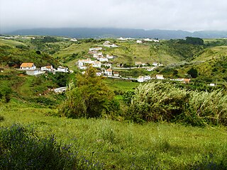
Santo Espírito is a Portuguese civil parish, located in the municipality of Vila do Porto, in the autonomous region of Azores. The population in 2011 was 588, in an area of 26.68 km².

<span class="mw-page-title-main">Alandroal</span> Municipality in Alentejo, Portugal

Alandroal is a municipality in the Portuguese district of Évora located on the eastern frontier with Spain along the right margin of the Guadiana River in the Central Alentejo region. It is located 341 metres (1,119 ft) above sea level, northeast of Évora and southeast of Estremoz. The population in 2011 was 5,843, in an area of 542.68 km2.

<span class="mw-page-title-main">Sines</span> Municipality in Alentejo, Portugal

Sines is a town and a municipality in Portugal. The municipality, divided into two parishes, has around 14,214 inhabitants (2021) in an area of 203.30 km2 (78.49 sq mi). Sines holds an important oil refinery and several petrochemical industries. It is also a popular beach spot and the main fishing harbour of Alentejo region.

<span class="mw-page-title-main">Lagoa, Portugal</span> Municipality in Algarve, Portugal

Lagoa is a city and municipality in the district of Faro, in the Portuguese region of Algarve. The population of the municipality in 2011 was 22,975, in an area of 88.25 km2. Its urban population, in the city of Lagoa proper, is 6,100 inhabitants. An important travel destination, its coast has won numerous accolades. Marinha Beach was considered by the Michelin Guide as one of the 10 most beautiful beaches in Europe and as one of the 100 most beautiful beaches in the world.

<span class="mw-page-title-main">Vila do Porto (parish)</span> Civil parish in Azores, Portugal

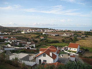
Vila do Porto is a civil parish in the municipality of Vila do Porto, located on the island of Santa Maria, in the Portuguese autonomous region of Azores. It is the southernmost and easternmost parish in the archipelago of Azores. The population in 2011 was 3,119, in an area of 25.55 km².

<span class="mw-page-title-main">Pessegueiro Island</span> Island in Portugal

Pessegueiro Island, literally island of the Peachtree, is a small island/islet located along the southwest coast of the civil parish of Porto Covo in the municipality of Sines. The island and the adjacent coast are part of Southwest Alentejo and Vicentine Coast Natural Park, but Pessegueiro island is also notable for the 15th-16th century fort located at its centre and Roman ruins along the coast.

<span class="mw-page-title-main">Porto Covo</span> Civil parish in Alentejo, Portugal

Porto Covo is one of the two civil parishes in the municipality of Sines, located along the western Alentejo coast of Portugal, about 170 km (110 mi) south of Lisbon. The population in 2011 was 1,038, in an area of 50.72 km2. Known for its beaches and ties to the ocean, the name Porto Covo likely translates as port of the covos, the term covo referring to a fishing net, used for capturing lobsters and crabs.

<span class="mw-page-title-main">Fort of Leça da Palmeira</span>

The Fort of Leça da Palmeira, or alternately the Castle of Matosinhos is a 17th-century fort located in civil parish of Leça da Palmeira, municipality of Matosinhos in the Greater Porto region of Portugal.

<span class="mw-page-title-main">Fort of Nossa Senhora da Rocha (Porches)</span> Fort in Porches, Lagoa, Portugal

The Fort of Nossa Senhora da Rocha is a medieval castle situated in the civil parish of Porches, in the municipality of Lagoa in Portuguese Algarve. Inside the fort is the Chapel of Nossa Senhora da Rocha, of uncertain date.

<span class="mw-page-title-main">Mexilhoeira Grande</span> Civil parish in Algarve, Portugal

Mexilhoeira Grande is a civil parish in the municipality (concelho) of Portimão in the southern Portuguese region of the Algarve. The population in 2011 was 4,029, in an area of 91.15 km².

Avanca is a civil parish in the municipality of Estarreja, in the central subregion of Baixo Vouga. The population in 2011 was 6,189, in an area of 21.07 km2.

<span class="mw-page-title-main">Fort of São João Baptista (Berlengas)</span>

The Fort of São João Baptista das Berlengas, or simply known as the Fort of the Berlengas, is located off western coast of Portugal, on the largest island of the archipelago of the Berlengas, in the municipality of Peniche in Oeste region. The fortification belonged to a group of defensive military structures meant to protect the municipality located on the coast.

<span class="mw-page-title-main">Castle of Alandroal</span> Medieval castle in Alandroal, Évora, Portugal

The Castle of Alandroal is a medieval castle in the civil parish of Alandroal, São Brás dos Matos e Juromenha, municipality of Alandroal, Portuguese district of Évora, classified as a National Monument.

<span class="mw-page-title-main">Church of Nossa Senhora do Bom Despacho</span> Church in Azores, Portugal

The Church of Nossa Senhora do Bom Despacho is the parochial church of the civil parish of Almagreira, located in the municipality of Vila do Porto, Portuguese archipelago of the Azores. It is a church of masonry, plastered and painted, constructed with decorative pilasters, friezes and cornices, molds and corner pinnacles, with a carved retable and tile covering.

<span class="mw-page-title-main">Fort Nossa Senhora da Luz (Lagos)</span>

The Fort Nossa Senhora da Luz, also known locally as Castle of Senhora da Luz is a fort in the civil parish of Luz, municipality of Lagos in the Portuguese Algarve, classified as a Property of Public Interest.

References

Notes

  1. 1 2 3 4 5 6 7 8 9 10 11 12 13 14 15 16 17 Mendonça, Isabel (1992), SIPA (ed.), Forte do Pessegueiro (IPA.00004092/PT041513020003) (in Portuguese), Lisbon, Portugal: SIPA –Sistema de Informação para o Património Arquitectónico, retrieved 7 February 2016
  2. 1 2 3 4 5 6 7 Oliveira, Catarina (2011), IGESPAR (ed.), Forte do Pessegueiro, incluindo a ilha do mesmo nome, abrangendo o Forte da Ilha de Dentro (in Portuguese), Lisbon, Portugal: IGESPAR - Instituto de Gestão do Património Arquitectónico e Arqueológico, retrieved 7 February 2016
  3. Augusto Cabrita & Julio Gil (1986), p.283

Sources