
The Fort of Guincho, also known as the Fort of Velas, is located at the edge of the Praia do Abano, along the southern edge of the coast of the civil parish of Alcabideche, in Cascais Municipality, Lisbon District, Portugal.. It was classified as Property of Public Interest by the national government on 29 September 1977, but today stands in a state of decay, even after studies to remodel the location as a visitors centre for the nearby Sintra-Cascais Nature Park.

The Fort of São Pedro do Estoril, also known as the Fort of Poça, is a medieval fortification, along the coast of the civil parish of Estoril, in the municipality of Cascais. Situated on the beach of Poça, the Fort was part of a group of fortifications during the Joanino era of Portuguese monarchs, built between 1642 and 1648 to form a defensive line between the Fort of São Julião da Barra and Cabo da Roca.

The Fort of São João Baptista is the ruins of a 16th-century maritime fort situated on the western edge of Praia Formoso, in the civil parish of Almagreira, municipality of Vila do Porto, on the Portuguese island of Santa Maria.
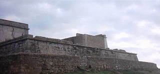
The Fort Nossa Senhora da Queimada also knows as Fort of Pessegueiro is a fort situated along the coast of the civil parish of Porto Covo, municipality of Sines, in the southern Alentejo of Portugal, across from the island of the same name.
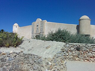
The Fort of São Jorge is located on the coastal highway EN 247, near the Oitavos dunes, in the parish and municipality of Cascais, Lisbon district, Portugal. It was one of a series of forts stretching from the Tower of Belem close to Lisbon to Cabo da Roca. It is now a museum.

The Santa Marta Lighthouse is situated to the south of the centre of Cascais, Lisbon District, Portugal, on the estuary of the River Tagus, providing a light for the Cascais Bay and for the town's new marina. It is a quadrangular masonry tower covered with white tiles, with blue horizontal stripes and a red lantern. The lighthouse was built on the grounds of the Santa Marta Fort, which now houses a lighthouse museum.

The Citadel of Cascais is a set of fortifications built between the 15th and 17th centuries to defend the Cascais coastline and River Tagus estuary and to protect against attacks on the capital of Portugal, Lisbon. The citadel incorporates three separate developments, the tower of Santo António de Cascais, the Fortress of Our Lady of Light, and the former Royal Palace area.

The Fort of Saint Anthony of Barra is located overlooking the sea, in the parish of Estoril, Cascais municipality, District of Lisbon, in Portugal. It is sometimes known as the Old Fort ), or as the Fort of Salazar as it was used by the Prime Minister, António de Oliveira Salazar as his seasonal residence during the Portuguese dictatorship. Until early 2018 the fort had been disused and subject to some vandalism, but it was then restored by the Municipality and opened for public viewing for the first time on 25 April 2018.

The Fort of São Teodósio da Cadaveira, located at Estoril, Lisbon District, Portugal, is one of a series of more than a dozen fortresses built between 1642 and 1648 during the period of the Portuguese Restoration War with the purpose of forming a defensive line between the Tower of Belém on the RiverTagus and Cabo da Roca on the Atlantic coast, in order to defend the city of Lisbon. Its construction began in April 1642, and was concluded the following year. Its location permitted crossfire with the nearby Fort of Saint Anthony of Barra to protect the cove of the Poça Beach. It was named in honour of Teodósio, 9th Duke of Bragança, the first-born son of John IV of Portugal.

The Fort of São Julião da Barra is the largest and most complete military defence complex in the Vauban style remaining in Portugal. It is located in São Julião da Barra, on the point of São Gião, in the parish of Oeiras e São Julião da Barra, Paço de Arcos e Caxias, Oeiras Municipality, Lisbon District. Considered in the past as the most important maritime fortification in the country, it had originally, together with the Fort of São Lourenço do Bugio, the role of controlling access to the port of Lisbon. It is currently the official residence of the Portuguese Minister of National Defence.

The Fort of São Lourenço do Bugio, also known as the fort of São Lourenço da Cabeça Seca or simply Torre do Bugio, is located in the middle of the estuary of the river Tagus, near Lisbon in Portugal. With no further need for its military functions, it is presently a lighthouse. The fort's location is on a sandbank formed by the silting of the river mouth, the result of the meeting of the river's waters with those of the Atlantic Ocean. Being the only sandbar of the Tagus river with its surface above the tide throughout the year, it was given the name “dry head”. The derivation of the name “Bugio” (monkey) is uncertain but may be related to the French word for candle, “bougie”, due to the similarity of the fort's structure with a candle on a candlestick.

The Fort of Nossa Senhora da Guia is located in Cascais, Lisbon District in Portugal. It was built during the Portuguese Restoration War (1640-1668), becoming operational in 1646. The site, which preserves some parts of the fort, is now occupied by a maritime laboratory under control of the Faculty of Sciences of the University of Lisbon.
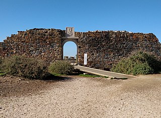
The Fort of Arrifana, or Fortress of Arrifana, ) is situated on the Vicentine Coast of the Algarve region of Portugal, on a promontory close to the town of Aljezur. It was originally constructed in 1635 with the intention of protecting fishing grounds for tuna as well as defending the coast. Its location provides a natural lookout over Arrifana Beach and the Vicentine Coast.
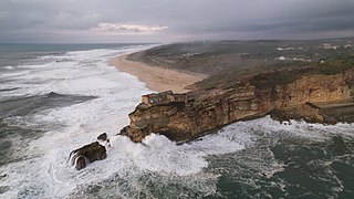
The Fort of São Miguel Arcanjo is situated in Nazaré, Oeste region of Portugal. It was first constructed in 1577 but has undergone remodeling and expansion on several occasions since then. The fort is a popular tourist site, particularly because of its proximity to a surfing area famous for the height of its waves. It now functions as both a lighthouse and a museum, which is devoted in part to surfing.

The Fort of Paimogo, also known as the Fort of Our Lady of the Angels of Paimogo, stands in a dominant position on Paimogo beach near the town of Lourinhã, Lisbon District in Portugal Constructed in 1674, it ceased to serve a military function in 1834 and is now under threat from coastal erosion. The fort presents an almost unique example of a fort from that period that has not undergone subsequent modification.

The Fort of Milreu, also known as the Fort of St. Peter of Milreu, is situated on the Atlantic coast 3km north of the town of Ericeira in Lisbon District of Portugal. Part of a programme to extend Portugal's coastal defences, it was built between 1670 and 1675.

The Fort of São Bruno is situated on the estuary of the River Tagus in Caxias, Oeiras municipality, near Lisbon in Portugal. It was built in 1647 and became operational in 1649 as part of the construction of a line of forts to control access to Lisbon, which stretched from Cabo da Roca on the Atlantic coast to the Belém Tower near Lisbon. The fort is well preserved, following its original design, and is considered one of the most attractive examples of maritime military architecture on the Portuguese coast. It presently serves as the headquarters of the Associação Portuguesa dos Amigos dos Castelos.

The Fort of Giribita, also referred to as the Fort of Our Lady of Porto Salvo and the Fort of Ponta do Guincho, is located on the right bank of the Tagus estuary, in the municipality of Oeiras, District of Lisbon, in Portugal. It was completed in 1649 during the Portuguese Restoration War (1640-1668), as part of the fortifications of Lisbon that stretched from Cabo da Roca on the Atlantic coast to Belém Tower close to Lisbon. It could exchange crossfire with the Fort of São Bruno to its east.
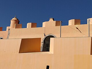
The Fort of São João das Maias, also known as the Fort of Oeiras, is located on the right bank of the River Tagus estuary, in the municipality of Oeiras in the Lisbon District of Portugal. It was constructed between 1644 and 1653. Until 2010 it had been allowed to fall into a state of advanced degradation but in that year it was restored.

The Fort of Nossa Senhora das Mercês de Catalazete, also known as the Fort of Catalazete, is located on the right bank of the River Tagus estuary in the municipality of Oeiras in the Lisbon District of Portugal. The fort dates back to 1762, when a small battery was erected on a site between the Fort of São Julião da Barra and the Fort of Santo Amaro do Areeiro, with the purpose of strengthening the defence provided by those two forts.


