
Fort Sumter is a sea fort built on an artificial island near Charleston, South Carolina to defend the region from a naval invasion. It was built after British forces captured and occupied Washington during the War of 1812 via a naval attack. The fort was still incomplete in 1861 when the Battle of Fort Sumter occurred, sparking the American Civil War. It was severely damaged during the battle and left in ruins. Although there were some efforts at reconstruction after the war, the fort as conceived was never completed. Since the middle of the 20th century, Fort Sumter has been open to the public as part of the Fort Sumter and Fort Moultrie National Historical Park, operated by the National Park Service.

Fort Wagner or Battery Wagner was a beachhead fortification on Morris Island, South Carolina, that covered the southern approach to Charleston Harbor. Named for deceased Lt. Col. Thomas M. Wagner, it was the site of two American Civil War battles in the campaign known as Operations Against the Defenses of Charleston in 1863, in which United States forces took heavy casualties while trying to seize the fort.

Fort Macon State Park is a North Carolina state park in Carteret County, North Carolina, in the United States. Located on Bogue Banks near Atlantic Beach, the park opened in 1936. Fort Macon State Park is the second most visited state park in North Carolina, with an annual visitation of 1.3 million, despite being one of the smallest state parks in North Carolina with 424 acres (1.72 km2). Fort Macon was built as part of the Third System of US fortifications, and was preceded by Fort Hampton of the Second System.

Fort Moultrie is a series of fortifications on Sullivan's Island, South Carolina, built to protect the city of Charleston, South Carolina. The first fort, formerly named Fort Sullivan, built of palmetto logs, inspired the flag and nickname of South Carolina, as "The Palmetto State". The fort was renamed for the U.S. patriot commander in the Battle of Sullivan's Island, General William Moultrie. During British occupation, in 1780–1782, the fort was known as Fort Arbuthnot.
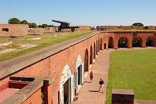
Fort Pulaski National Monument is located on Cockspur Island between Savannah and Tybee Island, Georgia. It preserves Fort Pulaski, the place where the Union Army successfully tested rifled cannon in combat during the American Civil War in 1862, the success of which rendered brick fortifications obsolete. The fort was also used as a prisoner-of-war camp.

The Parrott rifle was a type of muzzle-loading rifled artillery weapon used extensively in the American Civil War.

Fort Fisher was a Confederate fort during the American Civil War. It protected the vital trading routes of the port at Wilmington, North Carolina, from 1861 until its capture by the Union in 1865. The fort was located on one of Cape Fear River's two outlets to the Atlantic Ocean on what was then known as Federal Point or Confederate Point and today is known as Pleasure Island. The strength of Fort Fisher led to its being called the Southern Gibraltar and the "Malakoff Tower of the South". The battle of Fort Fisher was the most decisive battle of the Civil War fought in North Carolina.

Fort Morgan is a historic masonry pentagonal bastion fort at the mouth of Mobile Bay, Alabama, United States. Named for American Revolutionary War hero Daniel Morgan, it was built on the site of the earlier Fort Bowyer, an earthen and stockade-type fortification involved in the final land battles of the War of 1812. Construction was completed in 1834, and it received its first garrison in March of the same year.

Fort Jay is a coastal bastion fort and the name of a former United States Army post on Governors Island in New York Harbor, within New York City. Fort Jay is the oldest existing defensive structure on the island, and was named for John Jay, a member of the Federalist Party, New York governor, Chief Justice of the United States, Secretary of State, and one of the Founding Fathers of the United States. It was built in 1794 to defend Upper New York Bay, but has served other purposes. From 1806 to 1904 it was named Fort Columbus, presumably for explorer Christopher Columbus. Today, the National Park Service administers Fort Jay and Castle Williams as the Governors Island National Monument.

Fort Delaware is a former harbor defense facility, designed by chief engineer Joseph Gilbert Totten and located on Pea Patch Island in the Delaware River. During the American Civil War, the Union used Fort Delaware as a prison for Confederate prisoners of war, political prisoners, federal convicts, and privateer officers. A three-gun concrete battery of 12-inch guns, later named Battery Torbert, was designed by Maj. Charles W. Raymond and built inside the fort in the 1890s. By 1900, the fort was part of a three fort concept, the first forts of the Coast Defenses of the Delaware, working closely with Fort Mott in Pennsville, New Jersey, and Fort DuPont in Delaware City, Delaware. The fort and the island currently belong to the Delaware Department of Natural Resources and Environmental Control (DNREC) and encompass a living history museum, located in Fort Delaware State Park.

The Battle of Secessionville was fought on June 16, 1862, during the American Civil War. Confederate forces defeated the Union's only attempt to capture Charleston, South Carolina, by land. It is noted for the court martial of the Union brigadier general Henry Benham for trying to take James Island, which was against the orders given.

The siege of Fort Pulaski concluded with the Battle of Fort Pulaski fought April 10–11, 1862, during the American Civil War. Union forces on Tybee Island and naval operations conducted a 112-day siege, then captured the Confederate-held Fort Pulaski after a 30-hour bombardment. The siege and battle are important for innovative use of rifled guns which made existing coastal defenses obsolete. The Union initiated large-scale amphibious operations under fire.

The Battle of Grand Gulf was fought on April 29, 1863, during the American Civil War. Union Army forces commanded by Major General Ulysses S. Grant had failed several times to bypass or capture the Confederate-held city of Vicksburg, Mississippi, during the Vicksburg campaign. Grant decided to move his army south of Vicksburg, cross the Mississippi River, and then advance on the city. A Confederate Army division under Brigadier General John S. Bowen prepared defenses—Forts Wade and Cobun—at Grand Gulf, Mississippi, south of Vicksburg. To clear the way for a Union crossing, seven Union Navy ironclad warships from the Mississippi Squadron commanded by Admiral David Dixon Porter bombarded the Confederate defenses at Grand Gulf on April 29. Union fire silenced Fort Wade and killed its commander, but the overall Confederate position held. Grant decided to cross the river elsewhere.

The Second Battle of Charleston Harbor, also known as the Siege of Charleston Harbor, the Siege of Fort Wagner, or the Battle of Morris Island, took place during the American Civil War in the late summer of 1863 between a combined U.S. Army/Navy force and the Confederate defenses of Charleston, South Carolina.

Fort Independence is a granite bastion fort that provided harbor defenses for Boston, Massachusetts, located on Castle Island. Fort Independence is one of the oldest continuously fortified sites of English origin in the United States. The first primitive fortification was called "The Castle", placed on the site in 1634. It was rebuilt twice, then replaced around 1692 with a more substantial structure known as Castle William. It was abandoned by the British during the American Revolution, but the Americans renamed it Fort Adams and then Fort Independence. The existing granite fort was constructed between 1833 and 1851. Today it is preserved as a state park and fires occasional ceremonial salutes. Fort Independence was added to the National Register of Historic Places in 1970.

Siege artillery is heavy artillery primarily used in military attacks on fortified positions. At the time of the American Civil War, the U.S. Army classified its artillery into three types, depending on the gun's weight and intended use. Field artillery were light pieces that often traveled with the armies. Siege and garrison artillery were heavy pieces that could be used either in attacking or defending fortified places. Seacoast artillery were the heaviest pieces and were intended to be used in permanent fortifications along the seaboard. They were primarily designed to fire on attacking warships. The distinctions are somewhat arbitrary, as field, siege and garrison, and seacoast artillery were all used in various attacks and defenses of fortifications. This article will focus on the use of heavy artillery in the attack of fortified places during the American Civil War.
Blakely rifle or Blakely gun is the name of a series of rifled muzzle-loading cannon designed by British army officer Captain Theophilus Alexander Blakely in the 1850s and 1860s. Blakely was a pioneer in the banding and rifling of cannon but the British army declined to use Blakely's design. The guns were mostly sold to Russia and the Confederacy during the American Civil War. Blakely rifles were imported by the Confederacy in larger numbers than other Imported English cannon. The State of Massachusetts bought eight 9 in (23 cm) and four 11 in (28 cm) models.

Battery White was an artillery battery constructed by the Confederates during the American Civil War. Built in 1862–63 to defend Winyah Bay on the South Carolina coast, the battery was strongly situated and constructed; however, it was inadequately manned, and was captured without resistance during the final months of the war.
Fort Pringle is a historic artillery battery located at James Island, Charleston, South Carolina. It was built in 1863, as part of the James Island Siege Line and protect the Stono River, Johns Island and lower James Island. At the close of the war it was armed with nine heavy cannons. The earthen redoubt's river face measures approximately 360 feet, the right or upstream face 160 feet, the left or downstream face 400 feet, and the rear face approximately 520 feet in length. It has a 7.5 to 12.5 foot high parapet wall and 12.5 feet tall powder magazine.
Located in North Carolina on the Atlantic Coast, the Fort Caswell Historic District encompasses 2 sites, 43 buildings, and 23 structures; it was added to the National Register of Historic Places in 2013. The fort itself was occupied by various branches of the U.S. armed forces for most of the period between 1836 and 1945 and is now a part of the North Carolina Baptist Assembly, a Christian retreat, owned and operated by the Baptist State Convention of North Carolina. It is accessible by the public to a limited extent per the conditions set forth by the Assembly’s Director.


