Fort Smith, Montana

Last updated
Fort Smith, Montana
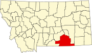
Big Horn County Montana Incorporated and Unincorporated areas Fort Smith Highlighted.svg
Location of Fort Smith, Montana
Coordinates: 45°18′28″N107°55′39″W / 45.30778°N 107.92750°W / 45.30778; -107.92750
Country United States
State Montana
County Big Horn
Area
[1]
  Total1.61 sq mi (4.17 km2)
  Land1.38 sq mi (3.57 km2)
  Water0.23 sq mi (0.59 km2)
Elevation
[2]
3,288 ft (1,002 m)
Population
 (2020)
  Total170
  Density123.19/sq mi (47.56/km2)
Time zone UTC-7 (Mountain (MST))
  Summer (DST) UTC-6 (MDT)
ZIP code
59035
Area code 406
FIPS code 30-28650
GNIS feature ID0794944 [2]

Fort Smith is a census-designated place (CDP) in Big Horn County, Montana, United States. The population was 161 at the 2010 census. [3] The town is named for the former Fort C.F. Smith. The North District of Bighorn Canyon National Recreation Area is accessed at Fort Smith.

Contents

The Crow name for this town is Annu'ucheepe, “Mouth of the canyon.” [4]

Geography

Fort Smith is located at 45°18′28″N107°55′39″W / 45.307906°N 107.927392°W / 45.307906; -107.927392 (45.307906, -107.927392). [5]

According to the United States Census Bureau, the CDP has a total area of 1.7 square miles (4.3 km2), of which 1.4 square miles (3.7 km2) is land and 0.23 square miles (0.6 km2), or 14.90%, is water. [3] It is located along the Bighorn River where it exits from Bighorn Canyon. Montana Highway 313 ends at Fort Smith and leads northeast 42 miles (68 km) to Hardin and Interstate 90.

According to the Köppen Climate Classification system, Fort Smith has a warm-summer humid continental climate, abbreviated "Dfb" on climate maps.

Climate data for Yellowtail Dam, Montana, 19912020 normals, extremes 1948present
MonthJanFebMarAprMayJunJulAugSepOctNovDecYear
Record high °F (°C)71
(22)
72
(22)
82
(28)
89
(32)
98
(37)
107
(42)
110
(43)
107
(42)
104
(40)
94
(34)
78
(26)
72
(22)
110
(43)
Mean maximum °F (°C)59.7
(15.4)
62.1
(16.7)
72.1
(22.3)
81.2
(27.3)
87.5
(30.8)
96.4
(35.8)
102.1
(38.9)
100.5
(38.1)
95.2
(35.1)
83.1
(28.4)
68.9
(20.5)
61.0
(16.1)
103.2
(39.6)
Average high °F (°C)38.5
(3.6)
40.0
(4.4)
50.3
(10.2)
57.9
(14.4)
67.9
(19.9)
78.4
(25.8)
88.8
(31.6)
87.4
(30.8)
76.1
(24.5)
60.5
(15.8)
47.5
(8.6)
39.4
(4.1)
61.1
(16.1)
Daily mean °F (°C)29.0
(−1.7)
30.5
(−0.8)
39.1
(3.9)
46.8
(8.2)
55.9
(13.3)
65.6
(18.7)
74.0
(23.3)
72.3
(22.4)
62.3
(16.8)
49.3
(9.6)
37.8
(3.2)
30.3
(−0.9)
49.4
(9.7)
Average low °F (°C)19.6
(−6.9)
21.0
(−6.1)
27.9
(−2.3)
35.6
(2.0)
44.0
(6.7)
52.7
(11.5)
59.2
(15.1)
57.3
(14.1)
48.6
(9.2)
38.0
(3.3)
28.2
(−2.1)
21.3
(−5.9)
37.8
(3.2)
Mean minimum °F (°C)−6.0
(−21.1)
−0.4
(−18.0)
6.4
(−14.2)
21.1
(−6.1)
31.5
(−0.3)
41.0
(5.0)
49.7
(9.8)
45.6
(7.6)
34.7
(1.5)
20.0
(−6.7)
5.8
(−14.6)
−2.8
(−19.3)
−14.2
(−25.7)
Record low °F (°C)−30
(−34)
−32
(−36)
−20
(−29)
4
(−16)
21
(−6)
31
(−1)
32
(0)
35
(2)
20
(−7)
−11
(−24)
−14
(−26)
−28
(−33)
−32
(−36)
Average precipitation inches (mm)0.72
(18)
0.83
(21)
1.21
(31)
1.95
(50)
2.62
(67)
2.27
(58)
1.15
(29)
0.78
(20)
1.67
(42)
1.98
(50)
0.77
(20)
0.72
(18)
16.67
(424)
Average snowfall inches (cm)8.8
(22)
7.4
(19)
8.4
(21)
3.0
(7.6)
0.2
(0.51)
0.0
(0.0)
0.0
(0.0)
0.0
(0.0)
0.0
(0.0)
3.0
(7.6)
5.8
(15)
7.3
(19)
43.9
(111.71)
Average precipitation days (≥ 0.01 in)4.94.56.07.68.07.45.03.74.76.04.14.566.4
Average snowy days (≥ 0.1 in)2.32.21.40.80.10.00.00.00.00.71.22.411.1
Source 1: NOAA [6]
Source 2: National Weather Service [7]

Demographics

Historical population
CensusPop.Note
2020 170
U.S. Decennial Census [8]

As of the census [9] of 2000, there were 122 people, 51 households, and 31 families residing in the CDP. The population density was 103.6 inhabitants per square mile (40.0/km2). There were 143 housing units at an average density of 121.4 per square mile (46.9/km2). The racial makeup of the CDP was 64.75% White, 32.79% Native American, 2.46% from other races. Hispanic or Latino of any race were 4.92% of the population.

There were 51 households, out of which 39.2% had children under the age of 18 living with them, 49.0% were married couples living together, 5.9% had a female householder with no husband present, and 39.2% were non-families. 37.3% of all households were made up of individuals, and 3.9% had someone living alone who was 65 years of age or older. The average household size was 2.39 and the average family size was 3.26.

In the CDP, the population was spread out, with 34.4% under the age of 18, 3.3% from 18 to 24, 34.4% from 25 to 44, 20.5% from 45 to 64, and 7.4% who were 65 years of age or older. The median age was 34 years. For every 100 females, there were 159.6 males. For every 100 females age 18 and over, there were 158.1 males.

The median income for a household in the CDP was $24,250, and the median income for a family was $24,333. Males had a median income of $16,250 versus $12,045 for females. The per capita income for the CDP was $10,692. There were 68.2% of families and 50.0% of the population living below the poverty line, including 55.1% of under eighteens and none of those over 64.

Education

Fort Smith has an elementary school. Hardin High School serves 9th through 12th grade. [10]

Related Research Articles

<span class="mw-page-title-main">Big Horn County, Montana</span> County in Montana, United States

Big Horn County is a county located in the U.S. state of Montana. As of the 2020 census, the population was 13,124. The county seat is Hardin. The county, like the river and the mountain range, is named after the bighorn sheep in the Rocky Mountains. The county was founded in 1913. It is located on the south line of the state.

<span class="mw-page-title-main">Canyon Day, Arizona</span> CDP in Gila County, Arizona

Canyon Day is a census-designated place (CDP) in Gila County, Arizona, United States, on the Fort Apache Indian Reservation. The population was 1,209 at the 2010 census.

<span class="mw-page-title-main">Crow Agency, Montana</span> Census designated place in Montana, United States

Crow Agency is a census-designated place (CDP) in Big Horn County, Montana, United States and is near the actual location for the Little Bighorn National Monument and re-enactment produced by the Real Bird family known as Battle of the Little Bighorn Reenactment. The population was 1,616 at the 2010 census. It is the governmental headquarters of the Crow Native Americans. It is also the location of the "agency offices" where the federal Superintendent of the Crow Indian Reservation and his staff interacts with the Crow Tribe, pursuant to federal treaties and statutes.

<span class="mw-page-title-main">Hardin, Montana</span> City in Montana, United States

Hardin is a city in and the county seat of Big Horn County, Montana, United States. The population was 3,818 at the 2020 census.

<span class="mw-page-title-main">Pryor, Montana</span> Census-designated place in Montana, United States

Pryor is a census-designated place (CDP) in Big Horn County, Montana, United States. The community is located on Crow Tribe's reservation. The population was 618 at the 2010 census. The area is named for Nathaniel Hale Pryor, a sergeant in the Lewis and Clark Expedition.

<span class="mw-page-title-main">St. Xavier, Montana</span> Unincorporated community and census-designated place in Montana, United States

St. Xavier is an unincorporated community and census-designated place (CDP) in Big Horn County, Montana, United States. The CDP population was 83 at the 2010 census.

<span class="mw-page-title-main">Wyola, Montana</span> Census-designated place in Montana, United States

Wyola is a census-designated place (CDP) in Big Horn County, Montana, United States. The population was 215 at the 2010 census. 79% of the residents are Native American, and the majority are members of the Crow Nation.

<span class="mw-page-title-main">Fort Belknap Agency, Montana</span> Census-designated place in Montana, United States

Fort Belknap Agency is a census-designated place (CDP) in Blaine County, Montana, United States. As of the 2010 census, its population was 1,293.

<span class="mw-page-title-main">Radersburg, Montana</span> Census-designated place in Montana, United States

Radersburg is a census-designated place (CDP) in Broadwater County, Montana, United States. The population was 66 at the 2010 census.

<span class="mw-page-title-main">Winston, Montana</span> Census-designated place in Montana, United States

Winston is a census-designated place (CDP) in Broadwater County, Montana, United States. The population was 147 at the 2010 census.

<span class="mw-page-title-main">Carter, Montana</span> Census-designated place in Montana, United States

Carter is a census-designated place (CDP) in Chouteau County, Montana, United States. The population was 58 at the 2010 census.

<span class="mw-page-title-main">Loma, Montana</span> Census-designated place in Montana, United States

Loma is a census-designated place (CDP) in Chouteau County, Montana, United States. The population was 85 at the 2010 census.

<span class="mw-page-title-main">Kremlin, Montana</span> Census-designated place in Montana, United States

Kremlin is an unincorporated community and census-designated place (CDP) in Hill County, Montana, United States. The population was 98 at the 2010 census, down from 126 in 2000.

<span class="mw-page-title-main">Alder, Montana</span> Census-designated place in Montana, United States

Alder is a census-designated place (CDP) in Madison County, Montana, United States. The population was 86 at the 2020 census. The community takes its name from Alder Creek, the site of the second major gold discovery in Montana.

<span class="mw-page-title-main">St. Regis, Montana</span> Census-designated place in Montana, United States

St. Regis or Saint Regis is an unincorporated community and census-designated place (CDP) in Mineral County, Montana. The population was 319 at the time of the 2010 census.

<span class="mw-page-title-main">Clinton, Montana</span> CDP in Montana, United States

Clinton is a census-designated place (CDP) in Missoula County, Montana, United States. It is part of the 'Missoula, Montana Metropolitan Statistical Area'. The CDP was named for General Sir Henry Clinton. The population was 1,052 at the 2010 census, an increase from its population of 549 in 2000.

<span class="mw-page-title-main">Birney, Montana</span> Census-designated place in Montana, United States

Birney is a census-designated place (CDP) in Rosebud County, Montana, United States. The population was 108 at the 2000 census.

<span class="mw-page-title-main">Reed Point, Montana</span> CDP in Montana, United States

Reed Point is a census-designated place (CDP) in Stillwater County, Montana, United States. The population was 185 at the 2000 census.

<span class="mw-page-title-main">Custer, Montana</span> Village in Montana, United States

Custer is a village in Yellowstone County, Montana, United States. The population was 145 at the 2000 census.

<span class="mw-page-title-main">Power, Montana</span> CDP in Montana, United States

Power is a census-designated place (CDP) in Teton County, Montana, United States. The population was 171 at the 2000 census. The town is named after Montana pioneer, Thomas Charles Power, who platted the townsite in 1910.

References

  1. "ArcGIS REST Services Directory". United States Census Bureau. Retrieved September 5, 2022.
  2. 1 2 U.S. Geological Survey Geographic Names Information System: Fort Smith, Montana
  3. 1 2 "Geographic Identifiers: 2010 Demographic Profile Data (G001): Fort Smith CDP, Montana". U.S. Census Bureau, American Factfinder. Archived from the original on February 12, 2020. Retrieved June 25, 2013.
  4. "Fort Smith". Montana Place Names Companion. Montana Historical Society. Retrieved 11 April 2021.
  5. "US Gazetteer files: 2010, 2000, and 1990". United States Census Bureau. 2011-02-12. Retrieved 2011-04-23.
  6. "U.S. Climate Normals Quick Access". National Oceanic and Atmospheric Administration. Retrieved August 7, 2022.
  7. "NOAA Online Weather Data". National Weather Service. Retrieved August 7, 2022.
  8. "Census of Population and Housing". Census.gov. Retrieved June 4, 2016.
  9. "U.S. Census website". United States Census Bureau . Retrieved 2008-01-31.
  10. "Fort Smith Elementary". Hardin Public Schools. Retrieved 14 April 2021.