Tower Island is an Antarctic island 9 kilometres (5 nmi) long and 305 m (1,001 ft) high. It marks the north-east extent of Palmer Archipelago. It lies 37 kilometres (20 nmi) north-east of Trinity Island, separated by Gilbert Strait. Both islands are separated from the Davis Coast to the south by Orléans Strait, running northeast–southwest. The Pearl Rocks lie off the West Coast of Tower Island.
Trinity Island or Île de la Trinité or Isla Trinidad is an island 24 km (15 mi) long and 10 km (6 mi) wide in the northern part of the Palmer Archipelago, Antarctica. It lies 37 km (23 mi) east of Hoseason Island, 72.6 km (45 mi) south of Deception Island in the South Shetland Islands, and 10.3 km (6 mi) north-northwest of Cape Andreas on the Antarctic Peninsula. The island was named by Otto Nordenskiöld, leader of the 1901-1904 Swedish Antarctic Expedition (SAE) in commemoration of Edward Bransfield's "Trinity Land" of 1820.

Arrowsmith Peninsula is a cape about 40 miles (64 km) long on the west coast of Graham Land, west of Forel Glacier, Sharp Glacier and Lallemand Fjord, and northwest of Bourgeois Fjord, with Hanusse Bay lying to the northwest. It was surveyed by the Falkland Islands Dependencies Survey (FIDS) in 1955-58 and named for Edwin Porter Arrowsmith, Governor of the Falkland Islands.

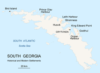
Prince Olav Harbour is a small harbour in the south west portion of Cook Bay, entered between Point Abrahamsen and Sheep Point, along the north coast of South Georgia.

Thatcher Peninsula is a mountainous peninsula in north-central South Georgia. Its total area is approximately 5,640 hectares, with roughly 1,620 ha covered in vegetation. It terminates to the north in Mai Point, rising between Cumberland West Bay to the west, and Cumberland East Bay and Moraine Fjord to the east. It is bounded to the southwest and south by Lyell Glacier and Hamberg Glacier. King Edward Cove on the east side of the peninsula is the site of the British Antarctic Survey (BAS) Grytviken station and the disused whaling station of the same name.

King Edward Cove is a sheltered cove in the west side of Cumberland East Bay, South Georgia. This cove and its surrounding features, frequented by early sealers at South Georgia, was charted by the Swedish Antarctic Expedition, 1901–04, under Otto Nordenskiöld who named it Grytviken. That name, meaning 'Pot Bay,' was subsequently assumed by the whaling station and settlement built in 1904. The cove got its present name in about 1906 for King Edward VII of the United Kingdom.

Barff Peninsula is a peninsula forming the east margin of Cumberland East Bay, South Georgia Island. It is 8 miles (13 km) long and extends northwest from Sörling Valley to Barff Point, its farthest extremity. It was probably first seen by the British expedition under James Cook in 1775. The peninsula as a whole takes its name from Barff Point, which was named for Royal Navy Lieutenant A.D. Barff of HMS Sappho, who, assisted by Captain C.A. Larsen, sketched a map of Cumberland Bay in 1906. Barff Point is considered the eastern headland of East Cumberland Bay.

Cape Buller is a rugged headland forming the west side of the entrance to the Bay of Isles on the north coast of South Georgia. It was discovered and named in 1775 by a British expedition under James Cook.

The Bay of Isles is a bay 9 miles (14 km) wide and receding 3 miles (5 km), lying between Cape Buller and Cape Wilson along the north coast of South Georgia. It was discovered in 1775 by a British expedition under James Cook and so named by him because numerous islands lie in the bay. Of South Georgia's 31 breeding bird species, 17 are found here.

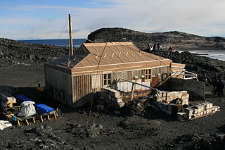
Cape Royds is a dark rock cape forming the western extremity of Ross Island, facing on McMurdo Sound, Antarctica. It was discovered by the British National Antarctic Expedition (BrNAE) (1901–1904) and named for Lieutenant Charles Royds, Royal Navy, who acted as meteorologist on the expedition. Royds subsequently rose to become an Admiral and was later Commissioner of the Metropolitan Police, London. The cape is the site of Shackleton's Hut, the expedition camp of the British Antarctic Expedition, 1907–09.

Elsehul is a bay along the north coast of South Georgia Island in the southern Atlantic Ocean. Elsehul is approximately 0.5 miles (0.8 km) wide, and is separated from nearby Undine Harbour by the narrow Survey Isthmus. The name "Elsehul" dates back to the period 1905–12 and was probably applied by Norwegian sealers and whalers working in the area. The Discovery Investigations (DI) expedition of 1930 surveyed Elsehul and the surrounding area, naming many features. A British Admiralty chart dating to 1931 provided the first instance of many other names; unless otherwise specified, features noted in this article were first named on this chart.

Ezcurra Inlet is an inlet forming the western arm of Admiralty Bay, King George Island, in the South Shetland Islands. It was charted by the French Antarctic Expedition, 1908–10, under Jean-Baptiste Charcot, and named "Fiord Ezcurra" after Pedro de Ezcurra, an Argentine politician and Minister of Agriculture in 1908, who assisted the French expedition.
East Ongul Island is an island in the Flatvaer Islands off of Antarctica. It is 2 kilometres (1 nmi) long, lying immediately east of the northern part of Ongul Island at the east side of the entrance of Lutzow-Holm Bay.
Blue Whale Harbour is a small, sheltered anchorage entered 1 nautical mile (2 km) west-southwest of Cape Constance, along the north coast of South Georgia Island. It was charted in 1930 by Discovery Investigations personnel, along with its constituent features. It is named for the blue whale, a commercially important species which was once widely distributed in polar and subpolar waters; numbers are now very small.
Breakwind Ridge is a prominent rocky ridge which is 2 nautical miles (4 km) long in a north–south direction and rises to 860 metres (2,820 ft), close southwest of the head of Fortuna Bay on the north coast of South Georgia. The name "Breakwind Range" was likely applied by Discovery Investigations personnel who mapped Fortuna Bay in 1929–30. Following a resurvey by the South Georgia Survey, 1951–52, the descriptive term was altered to "ridge", which is more suitable for this relatively small feature. The name suggests a beneficial function of this ridge in protecting anchorages at Fortuna Bay from violent southwest and westerly winds.
The Langhovde Hills are an extensive area of bare rocky hills along the eastern shore of Lützow-Holm Bay, in Queen Maud Land, Antarctica. They are located just south of Hovde Bay. They were mapped by Norwegian cartographers from aerial photographs taken by the Lars Christensen Expedition (LCE) in 1936–37, and named descriptively Langhovde. Many other features were mapped from surveys and air photos by the Japanese Antarctic Research Expedition (JARE) of 1957–62, and subsequently named by JARE Headquarters.

Mikkelsen Harbour is a small bay indenting the south side of Trinity Island between Skottsberg Point and Borge Point, in the Palmer Archipelago, Antarctica. It provides excellent anchorage for ships, and was frequently used by sealing vessels in the first half of the nineteenth century and by Norwegian whaling vessels at the beginning of the twentieth century.

Martel Inlet is an inlet forming the northeast head of Admiralty Bay, King George Island, in the South Shetland Islands off Antarctica. The inlet and most of its constituent features were charted in December 1909 by the Fourth French Antarctic Expedition under Jean-Baptiste Charcot and named "Fiord Martel" after J.L. Martel, a French politician. The mountain ridge Ullmann Spur is located at the head of the inlet.
Sandefjord Cove is a cove between Cape Ingrid and the terminus of Tofte Glacier on the west side of Peter I Island. A Norwegian expedition under Eyvind Tofte circumnavigated Peter I Island in the Odd I in 1927. In February 1929, the Norvegia under Nils Larsen carried out a series of investigations all around the island, landing on February 2 to hoist the Norwegian flag. The cove was named for Sandefjord, Norway, center of the Norwegian whaling industry.

New Harbour is a bay about 10 nautical miles wide between Cape Bernacchi and Butter Point along the coast of Victoria Land, due west of Ross Island.


