Forty Hall

Last updated

Forty Hall
Forty Hall 1.jpg
Forty Hall from the south
Type Manor House
Location Forty Hill
Coordinates 51°40′13″N0°04′07″W / 51.670265°N 0.068528°W / 51.670265; -0.068528
Area Enfield
Built1620s
Owner London Borough of Enfield
Listed Building – Grade I
Official nameForty Hall
Designated12 March 1951
Reference no. 1294469
Enfield London UK location map.svg
Red pog.svg
Location of Forty Hall in London Borough of Enfield

Forty Hall is a manor house of the 1620s in Forty Hill in Enfield, north London. The house, a Grade I listed building, is today used as a museum by the London Borough of Enfield. Within the grounds is the site of the former Tudor Elsyng Palace.

Contents

Location

Forty Hall is located in the north of the London Borough of Enfield, the northernmost borough of London. The hall and formal park are located on the top of Forty Hill, a level gravel plateau standing above the flood plain of the River Lea to the east, and the valley of the Turkey Brook to the north and west. The park slopes down into the valley, where the remains of old ponds lie on the London Clay. A loop in the former course of the New River forms the boundary of much of the estate, though this has since been re-routed to the east. To the north are Whitewebbs and Myddelton House. The road to the east was formerly the main route from Enfield to Waltham Cross, but traffic has been re-routed towards to A10.

History

Southern aspect and south-west wing FortyHall2.jpg
Southern aspect and south-west wing
Eastern aspect FortyHall3.jpg
Eastern aspect
Stable gateway (c.1650) FortyHallGateway.JPG
Stable gateway (c.1650)

The house was built between 1629 and 1632. It is generally said to have been built by Sir Nicholas Raynton or Rainton, a wealthy London haberdasher who was Lord Mayor of London from 1632 to 1633. [1] However Tuff, writing in 1858, says that it was built by Sir Hugh Fortee and bought by Raynton, quoting a 1635 survey describing a copyhold house "some time Hugh Fortee's, and late Sir Thomas Gurney's". [2] Lambert also gives Fortee as the origin of the name. [3]

The detailed history of the house has until recently been poorly understood, since it is known to have been built in the 1620s, but has the external appearance of an 18th-century house. A detailed examination was carried out for Enfield council as part of the Forty Hall Conservation Plan. [4] This concluded that the house was probably not designed by a famous architect such as Inigo Jones, but by a "clever artisan builder".

The original square house was not altered much in the 17th century other than a small extension to the northwest in 1636. [5] In 1640 Rainton was imprisoned for refusing to help Charles I raise a loan. He died in 1646 aged 77 and was buried at St Andrew's Church in Enfield. [1] The hall then passed to his great-nephew, also Nicholas. He was able to extend the estate northwards by buying and demolishing the neighbouring Elsyng Palace in 1656. In 1696 the hall passed to John Wolstenholme (probably a descendant of the financier and merchant of the same name and member of the Virginia Company), who carried out major refurbishment possibly following a fire, including construction of an extension to the south-west, and planted the avenue. In 1740 the house passed to Eliab Breton, who remodelled the ground floor. Later owners included Edmund Armstrong (1787) and James Meyer (1799), whose family built the nearby Jesus Church in 1835.

In 1894 the hall was bought by Henry Carrington Bowles [5] of the neighbouring Myddelton House for his son Major Henry Ferryman Bowles (1858–1943), MP for Enfield and later 1st Baronet Bowles. [6] In 1897 there were further changes including enlargement of the southwest wing. In 1951 the Bowles family sold it to the Municipal Borough of Enfield, the predecessor of the London Borough of Enfield. It has since been used as a museum.

The Hall closed to the public in late 2010 for a major redevelopment project funded by Enfield Council and the Heritage Lottery Fund. Alterations included the restoration of the original position of the staircase. [7] [8] The Hall reopened on 30 June 2012. [9]

The house and estate today

The Hall's permanent exhibition tells the story of the house and its estate throughout the ages and looks at the life and times of Sir Nicholas Rainton and life in the seventeenth century through a range of visual and audio interpretation and displays. There is also a range of guided tours, led by a Jacobean character. The exhibition programme focuses on art, ecology and heritage.

Grounds

The lake FortyHallLake.jpg
The lake
Cedar of Lebanon at Forty Hall Cedar of Lebanon, Forty Hall, Enfield - geograph.org.uk - 708717.jpg
Cedar of Lebanon at Forty Hall

The estate of around 107 hectares (260 acres) makes up part of the London Metropolitan Green Belt. Around the house are formal gardens, a small lake and a magnificent Cedar of Lebanon, one of the Great Trees of London, and the county girth Champion for Greater London. [10] The remainder includes a park that is open to the public and a farm. An avenue of trees runs down the hill from the house into the valley of the Turkey Brook, also known locally as Maidens Brook. The northern and much of the southern boundary are marked by the former course of the New River.

Related Research Articles

<span class="mw-page-title-main">Southgate, London</span> Human settlement in England

Southgate is a suburban area of North London, England, in the London Borough of Enfield, 8 miles (13 km) north of Charing Cross.

<span class="mw-page-title-main">London Borough of Enfield</span> London borough in United Kingdom

The London Borough of Enfield is a London borough in North London. It borders the London boroughs of Barnet to the west, Haringey to the south, and Waltham Forest to the southeast. To the north are the districts of Hertsmere, Welwyn Hatfield and Broxbourne, and to the east is Epping Forest District in Essex. The local authority is Enfield London Borough Council. Enfield's population is estimated to be 333,794; the main towns in the borough are Edmonton, Enfield, Southgate and Palmers Green. Enfield is the northernmost London borough.

<span class="mw-page-title-main">Enfield, London</span> Suburb of London

Enfield is a large town in north London, England, 10.1 miles (16.3 km) north of Charing Cross. It had a population of 156,858 in 2018. It includes the areas of Botany Bay, Brimsdown, Bulls Cross, Bullsmoor, Bush Hill Park, Clay Hill, Crews Hill, Enfield Highway, Enfield Lock, Enfield Town, Enfield Wash, Forty Hill, Freezywater, Gordon Hill, Grange Park, Hadley Wood, Ponders End, and World's End.
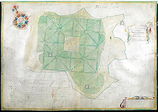
<span class="mw-page-title-main">Osidge</span> Human settlement in England

Osidge is a district in the London Borough of Barnet, between Brunswick Park and Southgate, just west of the border with the London Borough of Enfield. It may be loosely defined as the part of postal district N14 that is in Barnet. Osidge has no formal border and is entirely enclosed within the electoral ward of Brunswick Park, East Barnet; however Oak Hill Park forms a natural boundary to the north and Pymmes Brook to the west, with the A111 to the east and the Piccadilly line to the south and/or east.

<span class="mw-page-title-main">Edmonton, London</span> District of London, England

Edmonton is a town in north London, England within the London Borough of Enfield, a local government district of Greater London. The northern part of the town is known as Lower Edmonton or Edmonton Green, and the southern part as Upper Edmonton. Situated 8.4 miles (13.5 km) north-northeast of Charing Cross, it borders Enfield to the north, Chingford to the east, and Tottenham to the south, with Palmers Green and Winchmore Hill to the west. The population of Edmonton was 82,472 as of 2011.

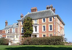
Elsyng Palace was a Tudor palace on the site of what are now the grounds of Forty Hall in Enfield, north London. Its exact location was lost for many years until excavations were carried out in the 1960s.

<span class="mw-page-title-main">Hugh Myddelton</span> Welsh businessman, civil engineer and politician

Sir Hugh Myddelton, 1st Baronet was a Welsh clothmaker, entrepreneur, mine-owner, goldsmith, banker and self-taught engineer. The spelling of his name is inconsistently reproduced, but Myddelton appears to be the earliest, and most consistently used in place names associated with him.

<span class="mw-page-title-main">Chace Community School</span> Secondary school in Forty Hill, Enfield Town, England

Chace Community School is a coeducational secondary school and sixth form located in Forty Hill, Enfield Town, England. It is situated on Churchbury Lane with its fields backing on to Baker Street. Chace is spelled with a 'c' rather than a 's', despite the school being close to the Chase Side area of Enfield. The school logo is the Enfield. Its colours are black and red.

<span class="mw-page-title-main">Arnos Grove</span> Human settlement in England

Arnos Grove is an area of north London, England, within the London Borough of Enfield. It is centred 7.5 miles (12 km) north of Charing Cross. It is adjacent to New Southgate. The natural grove, larger than today, was for many centuries the largest woodland in the chapelry of Southgate in the parish of Edmonton. It became inter-related with Arnos Park when its owner was permitted to enclose much of its area through the widespread legal practice of inclosure of the common land to create the former park, the heart of which is now public parkland.

<span class="mw-page-title-main">Forty Hill</span> Suburb in Enfield, London

Forty Hill is a largely residential suburb in the north of the London Borough of Enfield, England. To the north is Bulls Cross, to the south Enfield Town, to the west Clay Hill, and to the east Enfield Highway. Prior to 1965 it was in the historic county of Middlesex.

<span class="mw-page-title-main">Newby Hall</span> Grade I listed house in North Yorkshire, England

Newby Hall is a country house beside the River Ure in the parish of Skelton-on-Ure in North Yorkshire, England. It is 3 miles (4.8 km) south-east of Ripon and 6 miles (9.7 km) south of Topcliffe Castle, by which the manor of Newby was originally held. A Grade I listed building, the hall contains a collection of furniture and paintings and is surrounded by extensive gardens. Newby Hall is open to the public.

<span class="mw-page-title-main">Pymmes Park</span> Park in Edmonton, London

Pymmes Park is located in Edmonton, London and is bordered by the North Circular Road.

<span class="mw-page-title-main">Bulls Cross</span> Road and hamlet in the London Borough of Enfield, north London

Bulls Cross is a road and hamlet in Enfield, England, on the outskirts of north London, forming part of the Metropolitan Green Belt. Although it now lies within the ceremonial county of Greater London, prior to 1965 it was in the historic county of Middlesex. The area is situated west of the Great Cambridge Road, and south of the M25 motorway. Crews Hill is to the west, Bury Green to the north, and Bullsmoor to the east.

<span class="mw-page-title-main">Edward Augustus Bowles</span> British horticulturist (1865–1954)

Edward Augustus Bowles was a British horticulturalist, plantsman and garden writer. He developed an important garden at Myddelton House, his lifelong home at Bulls Cross in Enfield, Middlesex and his name has been preserved in many varieties of plant. The standard author abbreviation Bowles is used to indicate this person as the author when citing a botanical name.

<span class="mw-page-title-main">Sir Henry Bowles, 1st Baronet</span> British politician

Colonel Sir Henry Ferryman Bowles, 1st Baronet was a British Army officer and Conservative politician.

Sir Nicholas Rainton was an English merchant who was Lord Mayor of London in 1632.

<span class="mw-page-title-main">Sir Thomas Wolstenholme, 2nd Baronet</span>

Sir Thomas Wolstenholme, 2nd Baronet (c. 1622–1691) was an English baronet.

Sir John Wolstenholme, 3rd Baronet (1649–1709), of Forty Hall, Enfield, and Denmark Street, St. Giles-in-the-Fields, Middlesex, was an English landowner and Whig politician who sat in the English and British House of Commons between 1695 and 1709.

<span class="mw-page-title-main">Minchenden Oak Garden</span> Public park in Southgate, London, England

Minchenden Oak Garden is a public park in Southgate, London owned by the London Borough of Enfield.

References

  1. 1 2 Pam, David (1977). The New Enfield: Stories of Enfield Edmonton and Southgate. London Borough of Enfield.
  2. Tuff, J (1858). Historical, topographical and statistical notices of Enfield. J.H.Meyers. Retrieved 27 December 2011.
  3. Lambert, B (1806). The history and survey of London and its environs. Vol. IV. London: T.Hughes & M.Jones.
  4. "Forty Hall and Estate Heritage Lottery Bid". Archived from the original on 6 May 2008. (contains detailed maps and plans)
  5. 1 2 The Paul Drury Partnership. "Forty Hall Conservation Plan" (PDF). London Borough of Enfield. Retrieved 25 March 2008.[ dead link ]
  6. "The Bowles of Myddelton House Story" . Retrieved 25 March 2008.
  7. "The Forty Hall Development Project". Archived from the original on 14 May 2011. Retrieved 14 April 2011.
  8. "Enfield's crown jewel, Forty Hall, to be restored from next year". Newsquest Media Group. 25 March 2010. Retrieved 14 April 2011.
  9. "Forty Hall". Forty Hall & Estate. Archived from the original on 18 June 2012. Retrieved 8 February 2011.
  10. The Great Trees of London. Time Out Guides Ltd. 2010. p. 141. ISBN   978-1-84670-154-2.
  11. "Forty Hall 1, Antiques Roadshow, Series 43". bbc.co.uk. 3 January 2021. Retrieved 9 February 2021.
  12. "Forty Hall 2, Antiques Roadshow, Series 43". bbc.co.uk. 14 March 2021. Retrieved 18 March 2021.

Further reading