Guelmim-Es Semara was one of the sixteen former regions of Morocco from 1997 to 2015. It covered an area of 122,825 square kilometres (47,423 sq mi) and had a population of 501,921. The regional capital was Guelmim.
Tiguent is a small town and commune in south-western Mauritania, not far from the coast. In 2013 it had a population of 12,579.
Riyad is a suburb of Nouakchott and urban commune in western Mauritania.
Sebkha is a suburb of Nouakchott and urban commune in western Mauritania. It has a population of 72,245.
Toujouonine is a suburb of Nouakchott and urban commune in western Mauritania.
Bababé is a town and commune in the Brakna Region of southern Mauritania, located on the border with Senegal.
Malé or Sori Malé or Mal is a town and commune in the Brakna Region of southern Mauritania on the border with Senegal.
Dionaba or Djonaba is a town and commune in the Brakna Region of southern Mauritania.
Niabina is a town and commune in the Brakna Region of southern Mauritania.
Bagondine is a village and rural commune in the Brakna Region of southern Mauritania.
Dhar is a village and rural commune in the Hodh Ech Chargui Region of south-eastern Mauritania.
Sava, Mauritania is a village and rural commune in Mauritania.

Ten Hamadi or Tenhemad is a village and rural commune in southern Mauritania, in the Aïoun El Atrouss department of the Hodh El Gharbi region. In 2000, the commune had a population of 2,264, of which 155 lived in the village of Ten Hamadi itself, approximately 17 kilometres (11 mi) southwest of the main town and departmental capital of Aïoun El Atrouss. The population estimate in 2007 was 3,686, spread over 16 villages.

Aïn Fakroun is a town and commune in Algeria. According to the 2008 census it has a population of 48,804.

Aïn Zitoun is a town and commune in Oum El Bouaghi Province, Algeria. According to the 1998 census it has a population of 5993.
Foum Oudi is a town and rural commune in Béni Mellal Province, Béni Mellal-Khénifra, Morocco. At the time of the 2004 census, the commune had a total population of 7802 people living in 1404 households.
Foum El Anceur is a town and rural commune in Béni Mellal Province, Béni Mellal-Khénifra, Morocco. At the time of the 2004 census, the commune had a total population of 13,795 people living in 2590 households.
Ben Guecha is a town and commune in Taleb Larbi District, El Oued Province, Algeria. According to the 2008 census it has a population of 2,513, up from 1,036 in 1998, with an annual growth rate of 9.5%, the highest in the province.

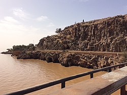
The Foum Gleita Dam is an arch dam on the Gorgol River near Foum Gleita in the Gorgol Region of Mauritania. The dam was completed in 1988 with the primary purpose of supplying water for the irrigation of up to 4,000 ha of crops.
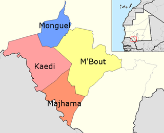
M'Bout is a department of Gorgol Region in Mauritania.