Kamour | |
|---|---|
Commune and town | |
| Country | |
| Area | |
| • Total | 385.9 sq mi (999.4 km2) |
| Population (2013) [1] | |
| • Total | 8,263 |
| • Density | 21/sq mi (8.3/km2) |
| Time zone | UTC±00:00 (GMT) |
Kamour is a town and commune in Mauritania.
Kamour | |
|---|---|
Commune and town | |
| Country | |
| Area | |
| • Total | 385.9 sq mi (999.4 km2) |
| Population (2013) [1] | |
| • Total | 8,263 |
| • Density | 21/sq mi (8.3/km2) |
| Time zone | UTC±00:00 (GMT) |
Kamour is a town and commune in Mauritania.
South Corning is a village in Steuben County, New York, United States. The population was 1,145 at the 2010 census. The village is in the town of the same name.

Boutilimit lies 164 km southeast of Mauritania's capital of Nouakchott.
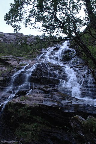
Glen Nevis is a glen in Lochaber, Highland, Scotland, with Fort William at its foot. It is bordered to the south by the Mamore range, and to the north by the highest mountains in the British Isles: Ben Nevis, Càrn Mor Dearg, Aonach Mòr, and Aonach Beag. It is home to one of the three highest waterfalls in Scotland, Steall Falls, where the Allt Coire a'Mhail joins the Water of Nevis in the glen. Below the waterfall is a steeply walled and impressive gorge. The scenic beauty of the glen has led to its inclusion in the Ben Nevis and Glen Coe National Scenic Area, one of 40 such areas in Scotland.
Aleg is the capital of the Brakna Region, in Mauritania. It is located at 17°3′0″N13°55′0″W.
North Shore Country Club is a private country club in Glenview, Illinois, a suburb of Chicago.
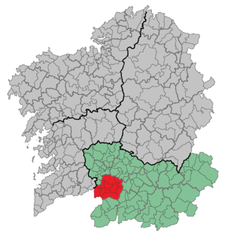
Terra de Celanova is a comarca in the Galician province of Ourense. The overall population of this local region is 17,497 (2019).
The Utah First Credit Union Amphitheatre is an outdoor amphitheater, located in West Valley City, Utah. From 2003 to 2024, the Amphitheater was named after USANA Health Sciences, a manufacturer of nutritional supplements. A new naming rights agreement with Utah First Credit Union was announced on January 23, 2024. It offers a view of the Wasatch Mountains. The venue opened July 2003.
Moudjeria is a town and commune in the Tagant Region of southern-central Mauritania, founded in 1934 as an administrative post by the French.

Baghdada is a town of Mardan District in the Khyber-Pakhtunkhwa, Pakistan.
Bermudian is an unincorporated community in Adams and York counties, Pennsylvania, United States.
Steins Creek, a stream or arroyo tributary to the San Simon River, that arises within an east–west running canyon, in Hidalgo County, New Mexico with its mouth in Cochise County, Arizona. This canyon provides the gap, called Stein's Pass, through which the railroad and Interstate 10 pass through the Peloncillo Mountains. Steins Creek has its source at 32°14′10″N108°59′43″W, and its mouth in the San Simon Valley, where its waters usually sink into the soil, short of any confluence with the San Simon River.
Creech is an unincorporated community in Benton County, Arkansas, United States.
Langville is an unincorporated community in Jefferson County, in the U.S. state of Pennsylvania.
Painter Creek is an unincorporated community in Darke County, in the U.S. state of Ohio.
Norton is an unincorporated community in Delaware County, in the U.S. state of Ohio.
Whitewater Draw, originally Rio de Agua Prieta, [Spanish: river of dark water], is a tributary stream of the Rio de Agua Prieta in Cochise County, Arizona. It was called Blackwater Creek by Philip St. George Cooke when his command, the Mormon Battalion, camped at a spring on its course on December 5, 1846.
Fairview is an unincorporated community in Lincoln County, in the U.S. state of Missouri.
Eaglette is an extinct town in Stoddard County, in the U.S. state of Missouri. The GNIS classifies it as a populated place.
Portia is an unincorporated community in Vernon County, in the U.S. state of Missouri.
Gasker is a small uninhabited islet in the Outer Hebrides of Scotland, 8 kilometres southwest of Scarp, off the west coast of Harris.
17°04′30″N12°02′08″W / 17.07500°N 12.03556°W
| | This Mauritania location article is a stub. You can help Wikipedia by expanding it. |