Ganki | |
|---|---|
Commune and village | |
| Country | |
| Time zone | UTC±00:00 (GMT) |
Ganki is a village and rural commune in Mauritania.
16°13′N13°14′W / 16.217°N 13.233°W
| | This Mauritania location article is a stub. You can help Wikipedia by expanding it. |
Ganki | |
|---|---|
Commune and village | |
| Country | |
| Time zone | UTC±00:00 (GMT) |
Ganki is a village and rural commune in Mauritania.
16°13′N13°14′W / 16.217°N 13.233°W
| | This Mauritania location article is a stub. You can help Wikipedia by expanding it. |

The Arctic Archipelago, also known as the Canadian Arctic Archipelago, is an archipelago lying to the north of the Canadian continental mainland, excluding Greenland and Iceland.

USS Card was an American Bogue-class escort carrier that saw service in World War II. She was named for Card Sound, a continuation of Biscayne Bay, south of Miami, Florida. She was the flagship of Task Group 21.14, a hunter-killer group formed to destroy German submarines in the North Atlantic.

Charlotte is the largest parish of Saint Vincent and the Grenadines, situated on the eastern coast of the island of Saint Vincent. With an area of 149 km², its size is comparable to that of the British Virgin Islands. It’s the country‘s largest parish by area and the second most populous one. The parish has the longest coastline of all the parishes and is also larger than the three smallest parishes combined. The parish possesses a very rough and rugged topography with very little flat land occurring towards the coast. as a result of these features, parts of the north of the parish cannot be accessed by a main road. Up until the building of a bridge over the Rabacca Dry River access to the north side of the river was not possible when rain caused the river to swell and make the path impassable.

Saint Patrick is an administrative parish of Saint Vincent and the Grenadines, on the island of Saint Vincent. According to the 2000 census, it had a population of 5,800, which makes Saint Patrick the least populous parish of Saint Vincent and the Grenadines. The parish consists of the middle portion of the leeward side of the main island. Its capital is Barrouallie.

Saint Andrew is an administrative parish of Saint Vincent and the Grenadines, on the island of Saint Vincent. Its capital is Layou.
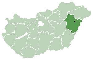
Biharnagybajom is a village in Hajdú-Bihar county, in the Northern Great Plain region of eastern Hungary. It has a population of 3100 people (2001) and was built on a flood plain.

Revilla Vallejera is a municipality and town located in the province of Burgos, Castile and León, Spain. According to the 2004 census (INE), the municipality has a population of 119 inhabitants.
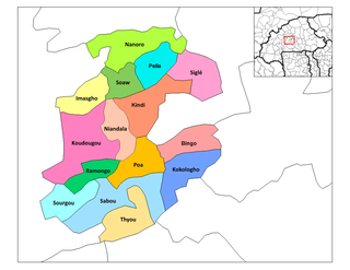
Ramongo is a department or commune of Boulkiemdé Province in central Burkina Faso. As of 2005 it has a population of 28,326. Its capital lies at the town of Ramongo.
Paudi Amarahi is a town and municipality in Gulmi District in the Lumbini Zone of central Nepal. At the time of the 1991 Nepal census it had a population of 4136 persons living in 742 individual households.
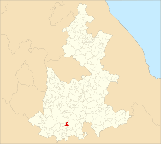
Santiago Zoochila is a town and municipality in Oaxaca in south-western Mexico. The municipality covers an area of 8.213km². It is part of the Villa Alta District in the center of the Sierra Norte Region.
Ahuehuetitla Municipality is a municipality in the Mexican state of Puebla in south-eastern Mexico.

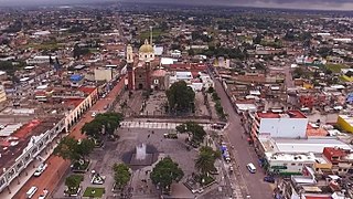
Honey is a town and municipality in the Sierra Norte region of the Mexican state of Puebla, on the border with the state of Hidalgo. It serves as the seat of the surrounding municipality of the same name.
Zacatelco Municipality is a municipality in the Mexican state of Tlaxcala in south-eastern Mexico.
Varovnik is a village in Sredets Municipality, in Burgas Province, in southeastern Bulgaria.

Masališkės is a village in Varėna district municipality, in Alytus County, in southeastern Lithuania. According to the 2001 census, the village has a population of 88 people.
Hirmuste is a village in Saaremaa Parish, Saare County in western Estonia.

Yamfo is a town in the Ahafo Region of Ghana. The town is known for the Yamfo Anglican Commercial School. The Anglican Commercial School is a second cycle institution. Also for the Yamfo College of Health which is affiliated with the University of Cape Coast.
Punta Patiño is a nature reserve area in Panama. The 65,025 acre preserve is owned by conservation group ANCON. The area is on the List of Ramsar wetlands of international importance.
Rank comparison chart of Non-commissioned officer and enlisted ranks for navies of Hispanophone states.