The Senegal River is a 1086-kilometre-long (675 mi) river in West Africa; much of its length marks part of the border between Senegal and Mauritania. It has a drainage basin of 270000 km2, a mean flow of 680 m3/s (24,000 cu ft/s), and an annual discharge of 21.5 km3 (5.2 cu mi). Important tributaries are the Falémé River, Karakoro River, and the Gorgol River. The river divides into two branches once it passes Kaédi The left branch, called the Doué, runs parallel to the main river to the north. After 200 km (120 mi) the two branches rejoin a few kilometers downstream of Podor.

The Mali Empire was an empire in West Africa from c. 1226 to 1670. The empire was founded by Sundiata Keita and became renowned for the wealth of its rulers, especially Mansa Musa. At its peak, Mali was the largest empire in West Africa, widely influencing the culture of the region through the spread of its language, laws, and customs.

Djenné is a Songhai town and urban commune in the Inland Niger Delta region of central Mali. The town is the administrative centre of the Djenné Cercle, one of the eight subdivisions of the Mopti Region. The commune includes ten of the surrounding villages and in 2009 had a population of 32,944.
Taghaza is an abandoned salt-mining centre located in a salt pan in the desert region of northern Mali. It was an important source of rock salt for West Africa up to the end of the 16th century when it was abandoned and replaced by the salt-pan at Taoudenni which lies 150 km (93 mi) to the southeast. Salt from the Taghaza mines formed an important part of the long distance trans-Saharan trade. The salt pan is located 857 km (533 mi) south of Sijilmasa, 787 km (489 mi) north-northwest of Timbuktu and 731 km (454 mi) north-northeast of Oualata.

Gao, or Gawgaw/Kawkaw, is a city in Mali and the capital of the Gao Region. The city is located on the River Niger, 320 km (200 mi) east-southeast of Timbuktu on the left bank at the junction with the Tilemsi valley.

Oualata or Walata is a small oasis town in southeast Mauritania, located at the eastern end of the Aoukar basin. Oualata was important as a caravan city in the thirteenth and fourteenth centuries as the southern terminus of a trans-Saharan trade route and now it is a World Heritage Site.

Chinguetti is a ksar and a medieval trading center in northern Mauritania, located on the Adrar Plateau east of Atar. Chinguetti had a population of 4,800 as of 2013.
Koumbi Saleh, or Kumbi Saleh, is the site of a ruined ancient and medieval city in south east Mauritania that may have been the capital of the Ghana Empire. It is also a commune with a population of 11,064.

Azougui was a town in north-western Mauritania, lying on the Adrar Plateau, north-west of Atar. In the eleventh century it was the first capital of the Almoravid dynasty, who conquered a territory stretching from the Ghana Empire to Morocco and the Iberian Peninsula.

Aoudaghost also transliterated as Awadaghust, Awdughast, Awdaghusht, Awdaghost, and Awdhaghurst is a former Berber town in Hodh El Gharbi, Mauritania. It was an important oasis town at the southern end of a trans-Saharan caravan route that is mentioned in a number of early Arabic manuscripts. The archaeological ruins at Tegdaoust in southern Mauritania are thought to be the remains of the medieval town.
Abū ʿUbayd ʿAbd Allāh ibn ʿAbd al-ʿAzīz ibn Muḥammad ibn Ayyūb ibn ʿAmr al-Bakrī, or simply al-Bakrī was an Arab Andalusian historian and a geographer of the Muslim West.

Trans-Saharan trade is trade between sub-Saharan Africa and North Africa that requires travel across the Sahara. Though this trade began in prehistoric times, the peak of trade extended from the 8th century until the early 17th century CE. The Sahara once had a different climate and environment. In Libya and Algeria, from at least 7000 BCE, pastoralism, large settlements and pottery were present. Cattle were introduced to the Central Sahara (Ahaggar) between 4000 and 3500 BCE. Remarkable rock paintings in arid regions portray flora and fauna that are not present in the modern desert.

Essouk is a commune and small village in the Kidal Region of Mali. The village lies 45 km northwest of Kidal in the Adrar des Ifoghas massif. The ruins of the medieval town of Tadmakka lie 2 km northeast of the present village. Between the 9th and the 15th centuries Tadmekka served as an important entrepôt for the trans-Saharan trade.

Tuat, or Touat, is a natural region of desert in central Algeria that contains a string of small oases. In the past, the oases were important for caravans crossing the Sahara.

Diogo Gomes was a Portuguese navigator, explorer and writer. Diogo Gomes was a servant and explorer of Portuguese prince, Henry the Navigator. His memoirs were dictated late in his life to Martin Behaim. They are an invaluable account of the Portuguese discoveries under Prince Henry the Navigator, and one of the principal sources upon which historians of the era have drawn. He explored and ascended up the Gambia River in West Africa and discovered some of the Cape Verde islands.
The Tajakant is a Sahrawi tribe of Berber Sanhaja origins. They speak Hassaniya Arabic.

Precolonial Mauritania, lying next to the Atlantic coast at the western edge of the Sahara Desert, received and assimilated into its complex society many waves of Saharan migrants and conquerors.

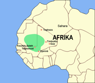
The Ghana Empire, also known as simply Ghana, Ghanata, or Wagadu, was a West African classical to post-classical era western-Sahelian empire based in the modern-day southeast of Mauritania and western Mali.
The Gao Empire was a kingdom that ruled the Niger bend from approximately the 7th century CE until their fall to the Mali Empire in the late 14th century. Ruled by the Za dynasty from the capital of Gao, the empire was an important predecessor of the Songhai Empire.


