
Fort Wayne is a city in and the county seat of Allen County, Indiana, United States. Located in northeastern Indiana, the city is 18 miles (29 km) west of the Ohio border and 50 miles (80 km) south of the Michigan border. The city's population was 263,886 as of the 2020 Census, making it the second-most populous city in Indiana after Indianapolis, and the 76th-most populous city in the United States. It is the principal city of the Fort Wayne metropolitan area, consisting of Allen and Whitley counties which had an estimated population of 423,038 as of 2021. Fort Wayne is the cultural and economic center of northeastern Indiana. In addition to the two core counties, the combined statistical area (CSA) includes Adams, DeKalb, Huntington, Noble, Steuben, and Wells counties, with an estimated population of 649,105 in 2021.

Adams County lies in northeastern Indiana in the United States and shares its eastern border with Ohio. It was officially established in 1836. The county seat is Decatur.

Wayne County is the most populous county in the U.S. state of Michigan. As of 2020, the United States Census placed its population at 1,793,561, making it the 19th-most populous county in the United States. The county seat is Detroit. The county was founded in 1796 and organized in 1815. Wayne County is included in the Detroit-Warren-Dearborn, MI Metropolitan Statistical Area. It is one of several U.S. counties named after Revolutionary War-era general Anthony Wayne.

Allen County is a county in the U.S. state of Indiana. As of the 2020 Census, the population was 385,410, making it the third-most populous county in Indiana. The county seat and largest city is Fort Wayne, the second largest city in Indiana.

Monroeville is a town in Monroe Township, Allen County, Indiana, United States. The population was 1,235 as of the 2010 census.

Allen County War Memorial Coliseum is a 13,000-seat multi-purpose arena located in Fort Wayne, Indiana, near present-day Johnny Appleseed Park. It opened in 1952 with a construction cost of nearly $3 million. The Allen County War Memorial Coliseum was originally designed to seat 8,103 for hockey or 10,240 for basketball. Opened in 1989, the Coliseum's $26 million Exposition Center contains 108,000-ft² (0.100-km2) devoted to hosting substantial trade shows and other events with seating for 7,500.
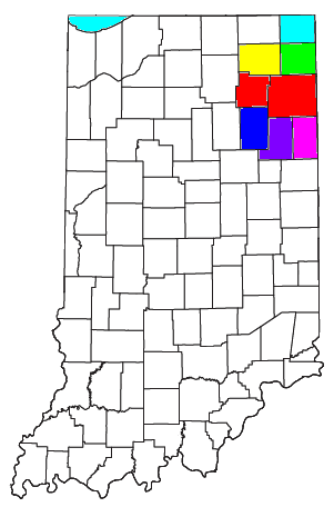
As of March 2020, the Fort Wayne–Huntington–Auburn Combined Statistical Area (CSA), or Fort Wayne Metropolitan Area, or Northeast Indiana is a federally designated metropolitan area consisting of eight counties in northeast Indiana, anchored by the city of Fort Wayne.
A quadripoint is a point on Earth where four distinct territories meet. The territories can be of different types, such as national and provincial. In North America, several such places are commonly known as Four Corners. Several examples exist throughout the world that use other names.

Northern Indiana is a region of the U.S. State of Indiana, including 26 counties which border the states of Illinois, Michigan, and Ohio. Northern Indiana is also considered part of the Great Lakes Megalopolis. The area is generally classified into other sub-regions; Northwest Indiana is closely tied with Chicago economically, culturally, and politically and is part of the Chicago metropolitan area. The north central region centers on South Bend metropolitan area, with economic connections to southwest Michigan. Northeast Indiana is centered on the Fort Wayne metropolitan area.

Milan Township is one of twenty townships in Allen County, Indiana, United States. Milan Township is located in east central Allen County, with the Maumee River meandering across the township. As of the 2010 census, its population was 3,749. The township is highly rural, with only 1,137 houses in the 2010 census. Many of the residents of Milan Township are Swiss Amish who mostly speak a Low Alemannic Alsatian dialect. Milan township is generally demarcated by Schwartz Road to the west, Notestine Road to the north, Sampson Road to the east, and Gar Creek Road to the south.

The Fort Wayne Mad Ants are an American professional basketball team of the NBA G League based in Fort Wayne, Indiana, and are affiliated with the Indiana Pacers. The team plays their home games at the Allen County War Memorial Coliseum. The Mad Ants won their first and only championship in 2014, when the G League was known as the NBA D-League. In September 2015, the Indiana Pacers purchased the Mad Ants.

US Highway 27 (US 27) is a part of the United States Numbered Highway System that runs from Miami, Florida, to Fort Wayne in the US state of Indiana. In Indiana, it is a State Road that enters the state in College Corner, Ohio, and West College Corner, Indiana. The 117.78 miles (189.55 km) of US 27 that lie within Indiana serve as a major conduit. Most of the highway is listed on the National Highway System. Various sections are rural two-lane highway, urbanized four-lane divided highway. The northernmost community along the highway is Fort Wayne in the northeast part of the state. The highway ends at an interchange with Interstate 69 (I–69) north of downtown Fort Wayne after serving the east central and northeast regions of Indiana.

Jackson Township is one of twenty townships in Allen County, Indiana, United States. As of the 2010 census, its population was 504.

Jefferson Township is one of twenty townships in Allen County, Indiana, United States. As of the 2010 census, its population was 2,109. Jefferson Township was organized in 1840.

Madison Township is one of twenty townships in Allen County, Indiana, United States. As of the 2010 census, its population was 1,771.

Monroe Township is one of twenty townships in Allen County, Indiana, United States. At the 2010 census, the population was 1,927.
Poe is an unincorporated community in Marion Township, Allen County, in the U.S. state of Indiana.

Robert E Armstrong was an American politician who served as mayor of Fort Wayne, Indiana, former councilman of Allen County, Indiana and former athletic director of Snider High School.
Airport Expressway, is a 7.9-mile (12.7 km) long expressway located in Allen County and the City of Fort Wayne, Indiana. The expressway, completed in 2001, provides access to the Fort Wayne International Airport. Airport Expressway begins as an extension of Lower Huntington Road in rural Allen County at an interchange with Interstate 69 (I–69) exit 299 and travels northeast, then east to end at Fairfield Avenue. None of the highway is listed on the National Highway System. Various sections are rural four-lane undivided highway and urbanized four-lane divided highway.
East Liberty is an unincorporated community in Monroe Township, Allen County, in the U.S. state of Indiana.


