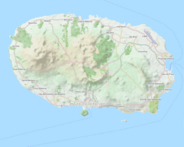
Terceira is a volcanic island in the Azores archipelago, about a third of the way across the North Atlantic Ocean at a similar latitude to Portugal's capital Lisbon, and the island group is an insular part of Portugal. It is one of the larger islands of the archipelago, with a population of 53,311 inhabitants in an area of approximately 396.75 km².

Angra do Heroísmo, or simply Angra, is a city and municipality on Terceira Island, Portugal, and one of the three capital cities of the Azores. Founded in 1478, Angra was historically the most important city in the Azores, as seat of the Bishop of the Azores, government entities, and having previously served as the capital city of Portugal during the Liberal Wars. The population in 2011 was 35,402, in an area of 239.00 km2. It was classified as a World Heritage site by UNESCO in 1983.
Cinco Ribeiras is a civil parish in the municipality of Angra do Heroísmo on the island of Terceira in the Portuguese archipelago of the Azores. The population in 2011 was 704, in an area of 12.80 km2.
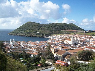
Monte Brasil is the remnants of a tuff volcano connecting the south coast of Terceira in the central Azores, overlooking the city of Angra do Heroísmo. Monte Brasil is flanked by two bays: the Bay of Angra to its east, and the Bay of Fanal to its west, and was used as a defensive point during the history of Angra, resulting in the construction of various forts and redoubts, including the Fortress of São João Baptista overlooking the city.
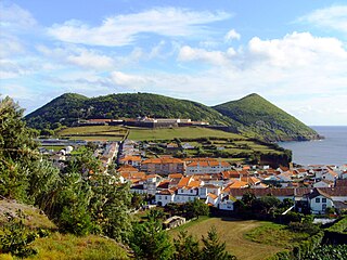
The Fortress of São João Baptista, also known as the Fort of São Filipe or Fort of Monte Brasil is a historic fortress and defensive emplacement, located in the civil parish of Sé, municipality of Angra do Heroísmo in the Portuguese island of Terceira, archipelago of the Azores.

Sabrina Island was an islet formed during the months of June and July 1811 by a submarine volcanic eruption off the coast of Ponta da Ferraria, São Miguel Island, Azores. The first person to land on the island was Commander James Tillard, captain of the British warship HMS Sabrina, who hoisted the Union Jack on the island and claimed sovereignty for Great Britain. A diplomatic row with Portugal over the issue ensued, which the island's sinking back into the sea rendered moot.

The Algar do Carvão is an ancient lava tube or volcanic vent located in the central part of the island of Terceira in the Portuguese archipelago of the Azores. It lies within the civil parish of Porto Judeu in the municipality of Angra do Heroísmo.

Bay of Angra is a natural bay within the coastal extent of the municipality of Angra do Heroísmo, on the Portuguese island of Terceira in the archipelago of the Azores. Within an average depth of 40 metres (130 ft), the bay has been of historical importance to the island; since the 15th century, it was a port-of-call for returning merchant shipping from the East Indies and Brazil, laden with gold, silver, porcelain, spices, rare woods, and other goods. These ships would anchor in the Bay of Angra until supported by armed escorts, which would accompany the ships on the rest of their voyage to Portugal. The Bay at Angra provided shelter from northern and northwestern winds; only storms originating to the south or southeast, posed a threat. Nonetheless, the Bay is the final resting-place of several ships affected by the adverse winds: local archives and a rich oral tradition support the foundering of many ships against the leeward shore.
The Gruta das Mercês is a cave located along the Canada das Mercês, situated in the civil parish of Feteira, municipality of Angra do Heroísmo, in the Portuguese archipelago of the Azores.

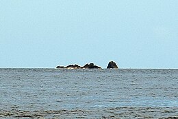
The Cabras Islets or Cabras Islet is an uninhabited dual islet located along the southern coast of the island of Terceira in the Portuguese archipelago of the Azores. The group, with a total area of 29 hectares and perimeter of 3,239 metres (10,627 ft), is the largest islet in the Azores. Locals normally refer to it as a single islet, but it comprises two landforms: the Ilhéu Pequeno and the Ilhéu Grande.

The Cemetery of Anchors is a subaquatic archaeological site, situated within the Bay of Angra, in the civil parish of Sé, municipality of Angra do Heroísmo, on the Portuguese island of Terceira, in the Azores.

The Fort of Negrito is a 16th-century maritime fort situated in the civil parish of São Mateus da Calheta, in the municipality of Angra do Heroísmo on the island of Terceira, Azores, Portugal.
The Fort of Má Ferramenta, near the port of the civil parish of São Mateus da Calheta, municipality of Angra do Heroísmo, along the southern coast of the Portuguese island of Terceira, in the archipelago of the Azores. Located in a dominant position over this coastal stretch of coast that sheltered anchored ships, it was a fortification used as a defence against attacks from pirates and corsairs, that frequented the waters of the mid-Atlantic.

The Fort of Cinco Ribeiras, also known as the Fort of Nossa Senhora do Pilar or Fort of São Bartolomeu, ruins of a 16th-century fortification located in the municipality of Angra do Heroísmo, along the southeast coast of Terceira, Portuguese archipelago of the Azores.

Monchique Islet is a small uninhabited islet off the coast of the island of Flores, west of the village of Fajã Grande, in the western part of the Portuguese archipelago of the Azores. It is the westernmost point of Portugal and, if considered part of Europe, is Europe's westernmost point as well.

The Ponta das Contendas Lighthouse is lighthouse located along the promontory of Contendas, in the civil parish of São Sebastião, municipality of Angra do Heroísmo on the island of Terceira, in the Portuguese archipelago of the Azores.
The Fort of the Church São Mateus da Calheta, also referred to as the Forte da Igreja, are the coastal ruins of a 16th-century fort situated in the civil parish of São Mateus da Calheta, municipality of Angra do Heroísmo, on the Portuguese island of Terceira, in the archipelago of the Azores. It was destroyed, along with the church, in 1893 during a cyclone; while the church was eventually reconstructed some years later, the fort was abandoned and left to ruin.
The Madalena Islets are two uninhabited islets located in the Faial-Pico Channel about 0.5 nautical miles away from Madalena harbor, off the coast of the island of Pico in the Portuguese archipelago of the Azores. The islets are also visible from Horta, Faial, and from the ferries which travel regularly between Horta and Madalena. Locally, the shorter of the two islets is known as Ilhéu Deitado, while the taller islet is known as Ilhéu em Pé.

Vila Franca Islet is a vegetated uninhabited islet located off the south-central coast of the island of São Miguel in the Portuguese archipelago of the Azores. The entire islet and surrounding waters constitute a protected nature reserve, while remaining a popular destination for swimming and cliff diving.