Francop

Last updated
Francop
Willkommen Altes Land Francop03.jpg
Location of Francop
Francop
Germany adm location map.svg
Red pog.svg
Francop
Germany Hamburg adm location map.svg
Red pog.svg
Francop
Coordinates: 53°30′00″N9°51′00″E / 53.50000°N 9.85000°E / 53.50000; 9.85000
Country Germany
State Hamburg
City Hamburg
Borough Harburg, Hamburg
Area
  Total9.1 km2 (3.5 sq mi)
Population
 (2023-12-31) [1]
  Total738
  Density81/km2 (210/sq mi)
Time zone UTC+01:00 (CET)
  Summer (DST) UTC+02:00 (CEST)
Dialling codes 040
Vehicle registration HH

Francop is a quarter in the Harburg borough of the Free and Hanseatic city of Hamburg in northern Germany. In 2020 the population was 711.

Contents

History

Francop, probably founded in the mid-12th century, belonged - as to its government - to the Prince-Archbishopric of Bremen, established in 1180. [2] In religious respect, however, Francop formed part of the Roman Catholic Diocese of Verden until after 1566 its incumbent bishops lost papal recognition, except of a last Catholic bishop from 1630 to 1631, respectively. [2] In 1648 the Prince-Archbishopric was transformed into the Duchy of Bremen, which was first ruled in personal union by the Swedish and from 1715 on by the Hanoverian Crown. In 1823 the Duchy was abolished and its territory became part of the Stade Region. In 1932 Francop and other villages East of the Este were annexed to the County of Harburg in the then Lunenburg Region. By the Greater Hamburg Act of 1937 Francop was annexed to Hamburg state, and municipally integrated into the unity municipality of Hamburg (Einheitsgemeinde Hamburg) on 1 April 1938.

Geography

Timber framed farm - the oldest house in Francop (17th century) Francop - Hohenwischer Str 277.jpg
Timber framed farm – the oldest house in Francop (17th century)

In 2008 according to the statistical office of Hamburg and Schleswig-Holstein, the quarter has a total area of 9.1 km2. [3] Francop is part of the Altes Land region (old country or old land). In the north is the quarter Finkenwerder of the borough Hamburg-Mitte, in the east is the quarter Altenwerder, Moorburg, and Hausbruch. Francop borders in the south to Neugraben-Fischbek and in the west to Neuenfelde.

Demographics

In 2008 634 people were living in the Francop quarter. The population density was 70/km2 (181/sq mi). 17.1% were children under the age of 18, 19.4% were 65 years of age or older, and 3.3% were immigrants. 15 people were registered as unemployed. [3]

In 1999, there were 322 households, out of which 24.8% had children under the age of 18 living with them, and 34.8% of all households were made up of individuals. The average household size was 2.3. [4]

Population by year [3]

1987198819891990199119921993199419951996199719981999
725737732748753740719707721701713721721
200020012002200320042005200620072008
726698704701674662639636634

Politics

These are the results of Francop in the Hamburg state election:

Election SPD CDU Greens AfD Left FDP Others
202046,5 %24,2 %10,3 %6,0 %3,2 %3,1 %6,7 %
201541,0 %26,3 %6,1 %4,3 %6,0 %13,9 %2,4 %
201145,4 %31,5 %4,5 %1,5 %13,7 %3,4 %
200825,9 %59,3 %4,5 %3,1 %5,5 %1,7 %
200423,5 %59,3 %6,6 %3,7 %6,9 %
200123,0 %38,1 %5,2 %0,3 %9,0 %24,4 %
199736,8 %35,8 %9,0 %0,0 %4,7 %13,7 %
199338,7 %36,4 %6,6 %5,9 %12,4 %
199143,2 %46,2 %3,6 %0,0 %3,0 %4,0 %
198739,7 %52,4 %3,2 %4,5 %0,2 %
198635,3 %52,9 %6,3 %4,0 %1,5 %
Dec. 198238,8 %52,8 %5,6 %2,8 %0,0 %
Jun. 198232,1 %56,5 %8,1 %2,8 %0,5 %
197842,6 %49,6 %1,5 %4,9 %1,4 %
197434,9 %52,0 %11,7 %1,4 %
197044,7 %41,2 %7,8 %6,3 %
196639,5 %48,4 %7,1 %5,0 %

Notes

  1. "Bevölkerung in Hamburg am 31.12.2023 nach Stadtteilen". Statistisches Amt für Hamburg und Schleswig-Holstein. May 2024.
  2. 1 2 Michael Schütz, „Die Konsolidierung des Erzstiftes unter Johann Rode", in: Geschichte des Landes zwischen Elbe und Weser: 3 vols., Hans-Eckhard Dannenberg and Heinz-Joachim Schulze (eds.) on behalf of the Landschaftsverband der ehemaligen Herzogtümer Bremen und Verden, Stade: Landschaftsverband der ehemaligen Herzogtümer Bremen und Verden, 1995 and 2008, vol. I 'Vor- und Frühgeschichte' (1995; ISBN   978-3-9801919-7-5), vol. II 'Mittelalter (einschl. Kunstgeschichte)' (1995; ISBN   978-3-9801919-8-2), vol. III 'Neuzeit' (2008; ISBN   978-3-9801919-9-9), (=Schriftenreihe des Landschaftsverbandes der ehemaligen Herzogtümer Bremen und Verden; vols. 7–9), vol. II: pp. 263–278, here pp. 270seq. ISBN   978-3-9801919-8-2.
  3. 1 2 3 Residents registration office, source: statistical office Nord of Hamburg and Schleswig-Holstein (2006)
  4. Source: statistical office Nord of Hamburg and Schleswig-Holstein (1999)

Related Research Articles

<span class="mw-page-title-main">Prince-Archbishopric of Bremen</span> Ecclesiastical principality of the Holy Roman Empire

The Prince-Archbishopric of Bremen — not to be confused with the modern Archdiocese of Hamburg, founded in 1994 — was an ecclesiastical principality (787–1566/1648) of the Holy Roman Empire and the Catholic Church that after its definitive secularization in 1648 became the hereditary Duchy of Bremen. The prince-archbishopric, which was under the secular rule of the archbishop, consisted of about a third of the diocesan territory. The city of Bremen was de facto and de jure not part of the prince-archbishopric. Most of the prince-archbishopric lay rather in the area to the north of the city of Bremen, between the Weser and Elbe rivers. Even more confusingly, parts of the prince-archbishopric belonged in religious respect to the neighbouring Diocese of Verden, making up 10% of its diocesan territory.

<span class="mw-page-title-main">Bremen-Verden</span> Territories and immediate fiefs of the Holy Roman Empire

Bremen-Verden, formally the Duchies of Bremen and Verden, were two territories and immediate fiefs of the Holy Roman Empire, which emerged and gained imperial immediacy in 1180. By their original constitution they were prince-bishoprics of the Archdiocese of Bremen and Bishopric of Verden.

<span class="mw-page-title-main">Arensch</span> Local area in Lower Saxony, Germany

Arensch is a local part of Cuxhaven, a town in Lower Saxony, Germany.

<span class="mw-page-title-main">Bremervörde</span> Town in Lower Saxony, Germany

Bremervörde is a town in the north of the district (Landkreis) of Rotenburg, in Lower Saxony, Germany. It is situated on the Oste river near the centre of the "triangle" formed by the rivers Weser and Elbe, roughly equidistant from the cities of Hamburg, Bremen and Cuxhaven.

<span class="mw-page-title-main">Jork</span> Town in Lower Saxony, Germany

Jork is a small town on the left bank of the Elbe, near Hamburg (Germany).

<span class="mw-page-title-main">Himmelpforten</span> Municipality in Lower Saxony, Germany

Himmelpforten is a municipality west of Hamburg (Germany) in the district of Stade in Lower Saxony. It is located on the Horsterbeck creek. Himmelpforten is also part and the seat of the Samtgemeinde Oldendorf-Himmelpforten.

<span class="mw-page-title-main">Jens Grand</span> Danish archbishop

Jens Grand, the Firebug was a Danish archbishop of Lund (1289–1302), titular Archbishop of Riga and Terra Mariana (1304–1310), and Prince-Archbishop of Bremen, known as the central figure of the second ecclesiastical struggle in Denmark in the late 13th century. He was an outstanding jurist of canon law.

<span class="mw-page-title-main">Selsingen</span> Municipality in Lower Saxony, Germany

Selsingen is a municipality in the district of Rotenburg, in Lower Saxony, Germany. It is situated approximately 15 kilometres (9.3 mi) southeast of Bremervörde, and 45 kilometres (28 mi) northeast of Bremen, and is twinned with the English village of Sawston in Cambridgeshire.

<span class="mw-page-title-main">Sittensen</span> Municipality in Lower Saxony, Germany

Sittensen is a municipality in the district of Rotenburg, in Lower Saxony, Germany. It is situated approximately 20 km northeast of Rotenburg, and 45 km southwest of Hamburg.

<span class="mw-page-title-main">Elsdorf, Lower Saxony</span> Municipality in Lower Saxony, Germany

Elsdorf is a municipality in the district of Rotenburg, in Lower Saxony, Germany.

<span class="mw-page-title-main">Mittelnkirchen</span> Municipality in Lower Saxony, Germany

Mittelnkirchen is a municipality in the district of Stade, Lower Saxony, Germany.

<span class="mw-page-title-main">Neuenkirchen, Stade</span> Municipality in Lower Saxony, Germany

Neuenkirchen is a municipality in the Altes Land, district of Stade, Lower Saxony, Germany.

<span class="mw-page-title-main">Sauensiek</span> Municipality in Lower Saxony, Germany

Sauensiek is a municipality in the district of Stade, Lower Saxony, Germany.

<span class="mw-page-title-main">Rübke</span> Ortsteil of Neu Wulmstorf in Lower Saxony, Germany

a village located in the north of Lower Saxony, Germany. Its population is 583 (2016). It consists of two main roads.

<span class="mw-page-title-main">Cranz, Hamburg</span> Quarter of Hamburg in Germany

Cranz is a quarter in the Harburg borough of Hamburg, Germany. It is on the left bank of the Elbe river and one of the 104 quarters of Hamburg. In 2020 the population was 843.

Valdemar Knudsen was a Danish clergyman and statesman. Valdemar was Bishop of Schleswig from 1188 to 1208, officiated as Steward of the Duchy of Schleswig between 1184 and 1187, and served as Prince-Archbishop of Bremen from 1192 to 1194 and again between 1206 and 1217. He held the latter office on the grounds of the archdiocesan capitular election as archbishop elect and of the royal investiture with the princely regalia, but lacked the papal confirmation.

Frederick of Saxe-Lauenburg (1554–1586), was a cathedral canon at Strasbourg Minster, chorbishop at Cologne Cathedral and cathedral provost (Dompropst), a function including the presidency of the chapter, at Bremen Cathedral.

Himmelpforten Convent was founded as a monastery of nuns following the Cistercian Rule during the 13th century in Himmelpforten, in today's Lower Saxony, Germany. During the 16th century, it was converted into use as a Lutheran Damsels' Convent. The Himmelpforten Convent was founded before 1255 and finally dissolved in 1647. The convent complex was built between 1300 and 1330. After 1645 the buildings, including the abbey, increasingly decayed, until they were little by little demolished. The dilapidated abbey was demolished in 1737 and replaced by today's St. Mary's Church which partially covers the foundations of the former abbey.

<span class="mw-page-title-main">Neuenwalde Convent</span> Lutheran convent in Lower Saxony, Germany

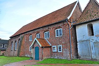
The Neuenwalde Convent is a Lutheran damsels' convent in Neuenwalde, a locality of Geestland, Lower Saxony, Germany.

<span class="mw-page-title-main">Holy Cross Church (Neuenwalde Convent)</span> Church in Geestland, Germany

The Holy Cross Church is the church of the Neuenwalde Convent. Convent and Holy Cross Church are owned by the Bremian Knighthood, based in Stade. However, church and parsonage, are used per usufruct by the Lutheran Neuenwalde Congregation in Neuenwalde, a locality of Geestland, Lower Saxony, Germany. Besides the Holy Cross Church, only used, the congregation uses and owns the chapel in Hymendorf.

References

Commons-logo.svg Media related to Francop at Wikimedia Commons