Hamburg Metropolitan Region

Last updated
Hamburg Metropolitan Region
Metropolregion Hamburg (German)
Elbphilharmonie Eastside View With Sandtorkai Quay Magellan Terraces Sandtorpark 2022-06-04 16-32.jpg
Hamburg
Metropolregion Hamburg Logo.svg
Anthem: Stadt Hamburg an der Elbe Auen  [ de ]
Metropolregion Hamburg 2017.png
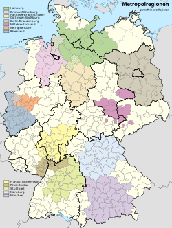
Location of the Hamburg metropolitan region in Germany
CountryFlag of Germany.svg  Germany
States Flag of Hamburg.svg  Hamburg
Flag of Lower Saxony.svg  Lower Saxony
Flag of Schleswig-Holstein.svg  Schleswig-Holstein
Flag of Mecklenburg-Western Pomerania.svg  Mecklenburg-Vorpommern
Largest Cities Hamburg, Lübeck
Area
  Metro
26,000 km2 (10,000 sq mi)
Population
[1]
   Metro
5,100,000
  Metro density192/km2 (500/sq mi)
GDP
[2]
  Metro€228.774 billion (2020)
Time zone UTC+1 (CET)
Website http://www.metropolregion.hamburg.de/

The Hamburg Metropolitan Region (German : Metropolregion Hamburg) is a metropolitan area centred around the city of Hamburg in northern Germany, consisting of eight districts (Landkreise) in the federal state of Lower Saxony, six districts (Kreise) in the state of Schleswig-Holstein and two districts in the state of Mecklenburg-Vorpommern along with the city-state of Hamburg itself. It covers an area of roughly 26,000 square kilometres (10,000 sq mi) and is home to more than 5.1 million inhabitants.

Contents

History

On 1 January 2006 the office of the Hamburg Metropolitan Region opened, as agreed in a state treaty of cooperation (Staatsvertrag über Zusammenarbeit) between Hamburg, Lower Saxony and Schleswig-Holstein. [3]

Geography

As of 2005, the Hamburg Metropolitan Region was made up of the city of Hamburg along with numerous rural districts in Lower Saxony and Schleswig-Holstein, altogether comprising 800 cities, towns and municipalities with an overall land area of 19,802 square kilometres (7,646 sq mi). [4] Since then it has expanded to cover the districts of Ludwigslust-Parchim (partially from 2012, entirely from 2017) [5] and Nordwestmecklenburg (from 2012) [6] in the state of Mecklenburg-Vorpommern.

States and districts

State District *Population
(2012)
Area
Pop. density
(2012)
Flag of Hamburg.svg  Hamburg 1,813,587755 km22,400/km2
Flag of Lower Saxony.svg  Lower Saxony Cuxhaven 198,1152,073 km296/km2
Harburg 239,2691,245 km2190/km2
Lüchow-Dannenberg 49,0821,220 km240/km2
Lüneburg 174,6851,323 km2130/km2
Rotenburg 162,1822,070 km278/km2
Soltau-Fallingbostel 136,0721,873 km273/km2
Stade 195,6061,266 km2150/km2
Uelzen 93,2841,454 km264/km2
Flag of Mecklenburg-Western Pomerania.svg  Mecklenburg-Vorpommern Ludwigslust 122,5642,517 km249/km2
Nordwestmecklenburg 155,8012,117 km274/km2
Flag of Schleswig-Holstein.svg  Schleswig-Holstein Dithmarschen 132,9651,405 km295/km2
Lauenburg 187,9051,263 km2150/km2
Lübeck 211,713214 km2990/km2
Neumünster 76,95172 km21,100/km2
Ostholstein 197,8821,391 km2140/km2
Pinneberg 298,826664 km2450/km2
Segeberg 261,9881,334 km2200/km2
Steinburg 130,1351,056 km2120/km2
Stormarn 232,911766 km2300/km2
Hamburg Metropolitan Region [7] [8] 4,990,30726078 km2191/km2

Largest cities and towns

City * or town Population
(2012)
Area
Pop. density
(2012)
Hamburg 1,813,587755 km22,400/km2
Lübeck 211,713214 km2990/km2
Schwerin 95,818130 km2730/km2
Neumünster 76,95172 km21,100/km2
Norderstedt 74,57458 km21,300/km2
Lüneburg 70,43870 km21,000/km2
Cuxhaven 48,829162 km2300/km2
Elmshorn 47,49021 km22,200/km2
Stade 45,198110 km2410/km2
Wismar 42,43341 km21,000/km2
Pinneberg 41,72622 km21,900/km2
Seevetal 39,921105 km2380/km2
Buxtehude 39,85876 km2520/km2
Buchholz i. d. N. 36,87575 km2490/km2
Uelzen 33,467136 km2250/km2
Winsen (Luhe) 32,638110 km2300/km2
Wedel 31,72534 km2940/km2
Ahrensburg 31,29235 km2890/km2
Itzehoe 30,95628 km21,100/km2
Geesthacht 29,09833 km2880/km2
Reinbek 26,34731 km2840/km2

* Districts and independent (German: kreisfrei) cities.
Ludwigslust was merged into Ludwigslust-Parchim in 2011; pop. data for 2010

  District free city

Larger Urban Zones

4. Hamburg metropolitan region Karte Metropolregionen.svg
4. Hamburg metropolitan region
Regions of Europe with the largest GDP per capita, Hamburg #4 Europeanuniongdphighdiagramde.svg
Regions of Europe with the largest GDP per capita, Hamburg #4

The Hamburg Larger Urban Zone (LUZ) as defined by Eurostat's Urban Audit covers an area of 7,303 km2 and in 2004 had a population of 3,134,620 inhabitants. [9] The Larger Urban Zone covers only the city of Hamburg and its directly neighbouring districts. [10] The Hamburg LUZ corresponds with the service area of the Hamburger Verkehrsverbund (HVV) transport association with an average population density of at least 150 inhabitants/km2.

State District *Population
(2012)
Area
Pop. density
(2012)
Flag of Hamburg.svg  Hamburg 1,813,587755 km22,400/km2
Flag of Lower Saxony.svg  Lower Saxony Harburg 239,2691,245 km2190/km2
Stade 195,6061,266 km2150/km2
Flag of Schleswig-Holstein.svg  Schleswig-Holstein Lauenburg 187,9051,263 km2150/km2
Pinneberg 298,826664 km2450/km2
Segeberg 261,9881,334 km2200/km2
Stormarn 232,911766 km2300/km2
Hamburg LUZ [11] [12] 2,903,198
Flag of Schleswig-Holstein.svg  Schleswig-Holstein Lübeck 211,713214.13 km2990/km2
Ostholstein 197,8821,391 km2140/km2
Lübeck LUZ [11] [12] 391,373
Flag of Bremen.svg  Bremen Bremerhaven 112,89578,87 km21,400/km2
Flag of Lower Saxony.svg  Lower Saxony Cuxhaven 198,1152,073 km296/km2
Bremerhaven LUZ [11] [12] 288,635

* Districts and independent (German: kreisfrei) cities.
not part of the Hamburg Metropolitan Region

See also

Related Research Articles

<span class="mw-page-title-main">Mecklenburg-Vorpommern</span> State in Germany

Mecklenburg-Vorpommern ; also known by its anglicized name Mecklenburg–Western Pomerania, is a state in the north-east of Germany. Of the country's sixteen states, Mecklenburg-Vorpommern ranks 14th in population; it covers an area of 23,213 km2 (8,963 sq mi), making it the sixth largest German state in area; and it is 16th in population density. Schwerin is the state capital and Rostock is the largest city. Other major cities include Neubrandenburg, Stralsund, Greifswald, Wismar, and Güstrow. It was named after the two regions of Mecklenburg and Vorpommern, and its name means the "nearer part of Pomerania", with the rest now lying in Poland.

<span class="mw-page-title-main">Herzogtum Lauenburg</span> District in Schleswig-Holstein, Germany

Herzogtum Lauenburg is the southernmost Kreis, or district, officially called Kreis Herzogtum Lauenburg, of Schleswig-Holstein, Germany. It is bordered by the district of Stormarn, the city of Lübeck, the state of Mecklenburg-Vorpommern, the state of Lower Saxony, and the city state of Hamburg. The district of Herzogtum Lauenburg is named after the former Duchy of Saxe-Lauenburg.

Nordwestmecklenburg is a Kreis (district) in the north-western part of Mecklenburg-Vorpommern, Germany. It is situated on the coast of the Baltic Sea and borders on Schleswig-Holstein to the west. Neighboring districts are Rostock, Ludwigslust-Parchim and the district-free city Schwerin, and the district Lauenburg and the district-free city Lübeck in Schleswig-Holstein. The district seat is the town Wismar.

<span class="mw-page-title-main">Ludwigslust (district)</span> District in Mecklenburg-Western Pomerania, Germany

Ludwigslust is a former Kreis (district) in the southwest of Mecklenburg-Vorpommern, Germany. Neighboring districts were Nordwestmecklenburg, the district-free city Schwerin, Parchim, Prignitz in Brandenburg, Lüchow-Dannenberg and Lüneburg in Lower Saxony and the district Lauenburg in Schleswig-Holstein. The district was disbanded at the district reform of September 2011. Its territory has been part of the Ludwigslust-Parchim district since.

Lüneburg is a district in Lower Saxony, Germany. It is bounded by the districts of Lüchow-Dannenberg, Uelzen, Heidekreis and Harburg, and the states of Schleswig-Holstein and Mecklenburg-Western Pomerania.

Niendorf may refer to the following places in Germany:

<span class="mw-page-title-main">Schaalsee</span>

Schaalsee is a 24 km2 (9.3 sq mi) lake in Germany. It forms part of the border between Schleswig-Holstein and Mecklenburg-Vorpommern. The town of Zarrentin is located on its southern shores. Other municipalities on the lake are Seedorf, Sterley, Salem, Kittlitz and Kneese.

<span class="mw-page-title-main">Wittendörp</span> Municipality in Mecklenburg-Vorpommern, Germany

Wittendörp is a municipality in the administrative district of Ludwigslust-Parchim in Mecklenburg-Vorpommern, Germany. The municipality has a seat in the Amt of Wittenburg from where it is administered. The municipality is about 25 kilometres west of Schwerin in the north of the administrative district Ludwigslust-Parchim and borders on the administrative district of Nordwestmecklenburg in the north. The river Schilde flows through the municipality.

<span class="mw-page-title-main">Kneese</span> Municipality in Mecklenburg-Vorpommern, Germany

Kneese is a municipality in the south west of the Nordwestmecklenburg district, in the Federal State of Mecklenburg-Vorpommern, Germany. The municipality is governed by the government office Gadebusch in the city Gadebusch.

Ludwigslust-Parchim is a district in the west of Mecklenburg-Vorpommern, Germany. The district seat is Parchim, a branch office of the administration is located in Ludwigslust.

Rostock is a district in the north of Mecklenburg-Vorpommern, Germany. It is bounded by the district Nordwestmecklenburg, the Baltic Sea, the district-free city Rostock and the districts Vorpommern-Rügen, Mecklenburgische Seenplatte and Ludwigslust-Parchim. The district seat is the town Güstrow.

West Mecklenburg is the western part of the German federal state of Mecklenburg-Vorpommern, covering an area of ca. 7,000 km². It incorporates parts of the historic territories of Mecklenburg-Schwerin and Mecklenburg-Strelitz and of Saxe-Lauenburg.

<span class="mw-page-title-main">Schaalsee Biosphere Reserve</span>

The Schaalsee Biosphere Reserve lies in western Mecklenburg-Vorpommern on its border with Schleswig-Holstein. From 1952 to 1990 large parts of the Schaalsee landscape lay within the military out of bounds area of the Inner German Border. That state-imposed rest period enable nature to develop so that in the year 2000 this valuable area was designated as a biosphere reserve. On the Schleswig-Holstein side of the border is the Lauenburg Lakes Nature Park founded in 1961.

<span class="mw-page-title-main">Mecklenburg Elbe Valley Nature Park</span>

The Mecklenburg Elbe Valley Nature Park is part of the UNESCO biosphere reserve of Elbe River Landscape. At over 400 river kilometres long, the Elbe River Landscape Biosphere Reserve runs through the five German states of: Saxony-Anhalt, Brandenburg, Lower Saxony, Mecklenburg-Vorpommern and Schleswig-Holstein. It lies in the district of Ludwigslust-Parchim in Mecklenburg-Vorpommern. The nature park was created in 1990 and legally established by act of state in 1998. It has an area of 426 km2 (164 sq mi).

<span class="mw-page-title-main">Evangelical Lutheran Church in Northern Germany</span> Group of churches in Germany

The Evangelical Lutheran Church in Northern Germany is a Lutheran member church of the Protestant Church in Germany.

<span class="mw-page-title-main">Ludwigslust-Parchim II – Nordwestmecklenburg II – Landkreis Rostock I</span> Federal electoral district of Germany

Ludwigslust-Parchim II – Nordwestmecklenburg II – Landkreis Rostock I is an electoral constituency represented in the Bundestag. It elects one member via first-past-the-post voting. Under the current constituency numbering system, it is designated as constituency 13. It is located in western Mecklenburg-Vorpommern, comprising the eastern parts of the districts of Ludwigslust-Parchim and Nordwestmecklenburg, and the northwestern part of Landkreis Rostock.

<span class="mw-page-title-main">Munich Metropolitan Region</span> Metropolitan region in Germany

The Munich Metropolitan Region is one of eleven metropolitan regions in Germany, consisting of the agglomeration areas of Munich, Augsburg, Ingolstadt, Landshut, Rosenheim and Landsberg am Lech. It is Germany's fifth most populous metropolitan region after the Rhine-Ruhr Metropolitan-Region, the Frankfurt Rhine-Main-Region, the Berlin-Brandenburg Metropolitan-Region and the Stuttgart Metropolitan-Region.

<span class="mw-page-title-main">Schwerin – Ludwigslust-Parchim I – Nordwestmecklenburg I</span> Federal electoral district of Germany

Schwerin – Ludwigslust-Parchim I – Nordwestmecklenburg I is an electoral constituency represented in the Bundestag. It elects one member via first-past-the-post voting. Under the current constituency numbering system, it is designated as constituency 12. It is located in western Mecklenburg-Vorpommern, comprising the city of Schwerin and western parts of the districts of Ludwigslust-Parchim and Nordwestmecklenburg.

References

  1. "Hamburg" (in German). Retrieved 12 June 2009.
  2. "Bruttoinlandsprodukt (BIP) in den Metropolregionen* in Deutschland im Jahr 2020" (in German).
  3. Impressum - metropolregion Hamburg (in German), retrieved 25 March 2009
  4. Hamburg Metropolitan Area fact sheet (PDF), Statistical office Hamburg and Schleswig-Holstein (Statistisches Amt für Hamburg und Schleswig-Holstein), 2006, archived from the original (PDF) on 18 January 2009, retrieved 25 March 2009
  5. "Metropolregion Hamburg / Landkreis Ludwigslust-Parchim".
  6. "Metropolregion Hamburg Landkreis Nordwestmecklenburg".
  7. Bevölkerungsstand und Bevölkerungsdichte am 31.12.2012, Metropolregion Hamburg, 2013
  8. Flächennutzung: Siedlungs- und Verkehrsfläche nach Art der tatsächlichen Nutzung am 31.12.2012, Metropolregion Hamburg, 2013
  9. "Hamburg". Archived from the original on 16 July 2011. Retrieved 15 June 2009.
  10. http://www.staedtestatistik.de/508.html Archived 2011-10-07 at the Wayback Machine Retrieved 15 June 2009.
  11. 1 2 3 Population by larger urban zone, eurostat, 2014
  12. 1 2 3 Map of metro regions [ permanent dead link ], eurostat, 2012

53°30′N10°00′E / 53.5°N 10.0°E / 53.5; 10.0