Frankport Frankfort | |
|---|---|
 Frankport  Frankport | |
| Coordinates: 42°35′34″N124°24′04″W / 42.5928873°N 124.4012147°W [1] | |
| Country | United States |
| State | Oregon |
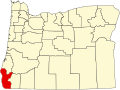
| County | Curry |
| Founded | 1850s |
| Abandoned | 1905 |
| Named after | S.H. Frank Tannery |
| Elevation | 69 ft (21 m) |
| Lowest elevation | 0 ft (0 m) |
| Time zone | UTC−08:00 (PST) |
| • Summer (DST) | UTC−07:00 (PDT) |
| ZIP Code | 97465 |
| Area codes | 541 and 458 |
| License plate | Oregon |
Frankport, also called Frankfort, [2] is a ghost town in Curry County, Oregon. The town was centered on Frankport Beach, located in what is now Sisters Rocks State Park. [3] Also part of Frankport was an island off the coast that was home to a shipping dock. [2] The island, one of the three Sisters Rocks, [4] was connected to the mainland by a bridge with a wooden railway. [2]