Harbor, Oregon

Last updated

Harbor, Oregon
Harbor, Oregon, beach.jpg
The beach at Harbor
Curry County Oregon Incorporated and Unincorporated areas Harbor Highlighted.svg
Location of Harbor, Oregon
Coordinates: 42°02′17″N124°15′10″W / 42.03806°N 124.25278°W / 42.03806; -124.25278
CountryUnited States
State Oregon
County Curry
Founded1894
Area
[1]
  Total2.31 sq mi (5.98 km2)
  Land1.92 sq mi (4.97 km2)
  Water0.39 sq mi (1.01 km2)
Elevation
[2]
115 ft (35 m)
Population
 (2020) [3]
  Total2,551
  Density1,327.95/sq mi (512.86/km2)
Time zone UTC−8 (Pacific (PST))
  Summer (DST) UTC−7 (PDT)
ZIP code
97415
Area code(s) 458 and 541
FIPS code 41-32100 [4]
GNIS feature ID2408351 [2]

Harbor (Tolowa: chit [5] ) is an unincorporated community in Curry County, Oregon, United States. It is located across the Chetco River from the city of Brookings. For statistical purposes, the United States Census Bureau has defined Harbor as a census-designated place (CDP). The census definition of the area may not precisely correspond to local understanding of the area with the same name. The population of the CDP was 2,391 at the 2010 census. [6]

Contents

History

The original name of the post office in the area was "Chetco", after the Chetco River. [7] It was established in 1863 and moved several times until it closed in 1910. [7] Meanwhile, a new post office named Harbor was established at the mouth of the Chetco River in 1894. [7] The name of the office may have originated from the Chetco Harbor Land and Townsite Company. [7]

Geography

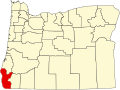
Harbor is located in southwestern Curry County along U.S. Route 101, 1 mile (1.6 km) east of the center of Brookings and 5 miles (8 km) north of the California state line. According to the United States Census Bureau, the CDP has a total area of 2.3 square miles (6.0 km2), of which 1.9 square miles (5.0 km2) is land and 0.39 square miles (1.0 km2), or 16.88%, is water. [6]

Climate

Harbor, like the Brookings area, has a cool-summer Mediterranean climate (Köppen climate classification Csb). [8] According to the Trewartha climate classification, it has a subtropical climate (despite being a little farther north than Chicago in latitude) and is one of the northernmost North American locations to have one.

It has cool winters during which intense rainfall is broken by weeks of cool, sunny weather. Mild, dry summers with average rainfall in July and August of less than 1 inch (25 mm) per month are usual. There are an average of only two afternoons annually with high temperatures of 90 °F (32.2 °C) or higher and an average of 1.5 mornings with low temperatures of 32 °F (0 °C) or lower. The record high temperature was 108.2 °F (42.3 °C) on July 9, 2008. The record low temperature was 18 °F (−7.8 °C) on December 8, 1972.

The wettest “rain year” in Harbor was from July 1937 to June 1938 with 107.62 inches (2,733.5 mm) and the driest from July 1976 to June 1977 with 40.30 inches (1,023.6 mm), although as much as 123.90 inches (3,147.1 mm) fell during calendar year 1996. The most rainfall in one month was 36.90 inches (937.3 mm) in December 1996. The most rainfall in 24 hours was 17.00 inches (431.8 mm) on October 14, 2016. Snow is rarer, but not unusual in Harbor, averaging only 0.7 inches or 0.018 metres per year. [9]

Because of its location, Harbor is subject to winter (and less frequently summer) temperatures considered unusually warm for the Oregon Coast or for that matter, the North Coast of California. Temperatures can reach 70 to 100 °F (21.1 to 37.8 °C) throughout the year. This is due mostly to its situation at the foot of the Klamath Mountains, from which winds compress and warm the air flowing onto Harbor. This is called the Brookings effect or Chetco effect, similar to the warm dry Santa Ana winds of coastal Southern California. Daffodils and other bulbs generally bloom in February. In the lowlands, heavy fog is common in the summer while the coastal hills are generally sunny and cool.[ citation needed ]

Climate data for Harbor at Brookings, OR (1981–2010 normals, extremes 1913–present)
MonthJanFebMarAprMayJunJulAugSepOctNovDecYear
Record high °F (°C)80
(27)
83
(28)
88
(31)
92
(33)
99
(37)
100
(38)
102
(39)
101
(38)
101
(38)
101
(38)
88
(31)
79
(26)
102
(39)
Mean maximum °F (°C)66.1
(18.9)
70.0
(21.1)
71.0
(21.7)
74.3
(23.5)
79.4
(26.3)
83.2
(28.4)
83.4
(28.6)
82.7
(28.2)
89.0
(31.7)
83.2
(28.4)
69.0
(20.6)
64.9
(18.3)
92.4
(33.6)
Average high °F (°C)55.4
(13.0)
56.8
(13.8)
57.9
(14.4)
59.9
(15.5)
64.0
(17.8)
67.1
(19.5)
68.7
(20.4)
68.2
(20.1)
68.6
(20.3)
65.0
(18.3)
58.1
(14.5)
54.8
(12.7)
62.1
(16.7)
Daily mean °F (°C)48.8
(9.3)
49.4
(9.7)
50.0
(10.0)
51.6
(10.9)
55.3
(12.9)
58.3
(14.6)
60.2
(15.7)
60.2
(15.7)
59.7
(15.4)
56.2
(13.4)
51.1
(10.6)
48.1
(8.9)
54.2
(12.3)
Average low °F (°C)42.1
(5.6)
42.1
(5.6)
42.1
(5.6)
43.3
(6.3)
46.6
(8.1)
49.5
(9.7)
51.7
(10.9)
52.3
(11.3)
50.7
(10.4)
47.6
(8.7)
44.1
(6.7)
41.3
(5.2)
46.2
(7.9)
Mean minimum °F (°C)33.8
(1.0)
34.0
(1.1)
34.3
(1.3)
35.7
(2.1)
39.3
(4.1)
43.8
(6.6)
46.8
(8.2)
46.7
(8.2)
44.2
(6.8)
40.3
(4.6)
34.8
(1.6)
32.7
(0.4)
30.0
(−1.1)
Record low °F (°C)21
(−6)
24
(−4)
29
(−2)
28
(−2)
32
(0)
34
(1)
39
(4)
37
(3)
34
(1)
24
(−4)
25
(−4)
18
(−8)
18
(−8)
Average precipitation inches (mm)12.07
(307)
10.14
(258)
9.47
(241)
6.51
(165)
4.04
(103)
1.99
(51)
0.52
(13)
1.01
(26)
1.63
(41)
5.40
(137)
11.77
(299)
14.19
(360)
78.89
(2,004)
Average precipitation days (≥ 0.01 in.)17.315.017.213.98.95.42.73.24.39.217.418.2142.5
Mean monthly sunshine hours 1501391992583203313703673011951641542,948
Source 1: [10]
Source 2: Worldweatheronline (sun) [11]

Demographics

Historical population
CensusPop.Note
2020 2,551
U.S. Decennial Census [12] [3]

As of the census [4] of 2000, there were 2,622 people, 1,333 households, and 798 families residing in the CDP. The population density was 1,399.6 inhabitants per square mile (540.4/km2). There were 1,691 housing units at an average density of 902.6 per square mile (348.5/km2). The racial makeup of the CDP was 94.20% White, 0.34% African American, 2.17% Native American, 0.19% Asian, 0.08% Pacific Islander, 0.92% from other races, and 2.10% from two or more races. Hispanic or Latino of any race were 3.05% of the population.

There were 1,333 households, out of which 11.0% had children under the age of 18 living with them, 52.6% were married couples living together, 5.6% had a female householder with no husband present, and 40.1% were non-families. 34.4% of all households were made up of individuals, and 18.6% had someone living alone who was 65 years of age or older. The average household size was 1.93 and the average family size was 2.41.

In the CDP, the population was spread out, with 11.5% under the age of 18, 4.1% from 18 to 24, 15.0% from 25 to 44, 28.5% from 45 to 64, and 40.9% who were 65 years of age or older. The median age was 60 years. For every 100 females, there were 97.3 males. For every 100 females age 18 and over, there were 96.0 males.

The median income for a household in the CDP was $22,829, and the median income for a family was $30,171. Males had a median income of $23,295 versus $21,692 for females. The per capita income for the CDP was $16,318. About 11.1% of families and 14.8% of the population were below the poverty line, including 15.9% of those under age 18 and 14.3% of those age 65 or over.

Related Research Articles

<span class="mw-page-title-main">Markleeville, California</span> Census-designated place in California, United States

Markleeville is a census-designated place (CDP) and the county seat of Alpine County, California, United States. The population was 191 at the 2020 census, down from 210 at the 2010 census.

<span class="mw-page-title-main">Occidental, California</span> Census-designated place in California, United States

Occidental is a census-designated place (CDP) in Sonoma County, California, United States. The population was 1,115 at the 2010 census, down from 1,272 at the 2000 census.

<span class="mw-page-title-main">Lihue, Hawaii</span> Census-designated place in Hawaii, United States

Lihue is an unincorporated community, census-designated place (CDP) and the county seat of Kauai County, Hawaii, United States. Lihue is the second-largest town on the Hawaiian island of Kauaʻi after Kapaʻa. As of the 2010 census, the CDP had a population of 6,455, up from 5,694 at the 2000 census.

<span class="mw-page-title-main">Kahului, Hawaii</span> Census-designated place in Hawaii, United States

Kahului is an unincorporated community and a census-designated place (CDP) in Maui County in the U.S. state of Hawaii. It hosts the county's main airport, a deep-draft harbor, light industrial areas, and commercial shopping centers. The population was 28,219 at the 2020 census. Kahului is part of the Kahului-Wailuku-Lahaina Metropolitan Statistical Area which comprises all of Maui County, including nearby Wailuku and the town and former whaling village of Lahaina.

<span class="mw-page-title-main">Heron, Montana</span> CDP in Montana, United States

Heron is a census-designated place (CDP) in Sanders County, Montana, named for the village of Heron which is located within it. The population of the entire CDP was 149 at the 2000 census.

<span class="mw-page-title-main">Minden, Nevada</span> County seat in Nevada, United States

Minden is a census-designated place (CDP) in Douglas County, Nevada, United States. The population was 3,001 at the 2010 census. It is the county seat of Douglas County and is adjacent to the town of Gardnerville. The Douglas campus of the Western Nevada College is located in Minden.

<span class="mw-page-title-main">Dover Beaches South, New Jersey</span> Populated place in Ocean County, New Jersey, US

Dover Beaches South, more commonly known as Ortley Beach, is an unincorporated community and census-designated place (CDP) located within Toms River, in Ocean County, in the U.S. state of New Jersey. As of the 2010 United States Census, the CDP's population was 1,209. Dover Beaches South is situated on the Barnegat Peninsula, a long, narrow barrier peninsula that separates Barnegat Bay from the Atlantic Ocean.

<span class="mw-page-title-main">North Beach Haven, New Jersey</span> Populated place in Ocean County, New Jersey, US

North Beach Haven is an unincorporated community and census-designated place (CDP) constituting a part of the Jersey Shore community of Long Beach Township, in southern Ocean County, in the U.S. state of New Jersey. The CDP is situated on Long Beach Island, a barrier island separating Barnegat Bay from the Atlantic Ocean.

<span class="mw-page-title-main">Powers, Oregon</span> City in Oregon, United States

Powers is a city in Coos County, Oregon, United States. The population was 689 at the 2010 census.

<span class="mw-page-title-main">Brookings, Oregon</span> City in Oregon, United States

Brookings is a city in Curry County, Oregon, United States. It was named after John E. Brookings, president of the Brookings Lumber and Box Company, which founded the city in 1908. As of the 2020 census, the population was 6,744.

<span class="mw-page-title-main">Gold Beach, Oregon</span> City in Oregon, United States

Gold Beach is a city in and the county seat of Curry County, Oregon, United States, on the Oregon Coast. The population was 2,241 at the 2020 census.

<span class="mw-page-title-main">Drain, Oregon</span> City in Oregon, United States

Drain is a city in Douglas County, Oregon, United States. The population was 1,151 at the 2010 census. Drain is named after town founder and politician Charles J. Drain, who donated 60 acres (24 ha) of nearby land to the Oregon and California Railroad in 1871.

<span class="mw-page-title-main">Riddle, Oregon</span> City in Oregon, United States

Riddle is a city in Douglas County, Oregon, United States. The population was 1,185 at the 2010 census.

<span class="mw-page-title-main">Coburg, Oregon</span> City in Oregon, United States

Coburg is a city in Lane County, Oregon, United States, 8 miles (13 km) north of Eugene. The city's population as of the 2020 census was 1,306. Founded in 1847, Coburg has retained the characteristics of traditional small town with walkable and close ties to the surrounding farming communities that stretch in all directions. Maintaining these characteristics is the central part of the city's community vision process completed in 2017.

<span class="mw-page-title-main">Waldport, Oregon</span> City in Oregon, United States

Waldport is a city in Lincoln County, Oregon, United States. The population was 2,033 at the 2010 census. The city is located on the Alsea River and Alsea Bay, 15 miles (24 km) south of Newport and 8 miles (13 km) north of Yachats.

<span class="mw-page-title-main">Grand Ronde, Oregon</span> Census-designated place in Oregon, United States

Grand Ronde is a census-designated place (CDP) and unincorporated community in Polk and Yamhill counties, Oregon, United States. Historically noted as a village in Polk County, the sphere of influence and community is in both Polk and Yamhill counties. The name of the community is a variation of the French Grande Ronde or "Grand Round" which could be in reference to the large round up of Native Americans peoples in the area who were settled on what was known as the Grand Ronde Indian Reservation, or possibly referencing the shape of the valley in which the community is located. As of the census of 2010, there were 1,661 people in 658 households are residing in Grand Ronde. It is part of the Salem Metropolitan Statistical Area.

<span class="mw-page-title-main">Moro, Oregon</span> City in Oregon, United States

Moro is a city in Sherman County, Oregon, United States. The population was 324 at the 2010 census. It is the county seat of Sherman County It’s currently the least-populous county seat in Oregon. Moro was incorporated on February 17, 1899, by the Oregon Legislative Assembly. It was named for Moro, Illinois.

<span class="mw-page-title-main">Hebbronville, Texas</span> County seat and Census-designated place in Texas, United States

Hebbronville is a census-designated place (CDP) in and the county seat of Jim Hogg County, Texas, United States. The population was 4,558 at the 2010 census. In 1918, Helen Sewel Harbison became the first woman in Texas to cast a ballot, two years before the implementation of the Nineteenth Amendment to the United States Constitution.

<span class="mw-page-title-main">Desert Aire, Washington</span> Census-designated place in Washington, United States

Desert Aire is a census-designated place (CDP) in Grant County, Washington, United States. Desert Aire's elevation is 560 ft (170 m). The population was 1,626 at the 2010 census, up from 1,124 at the 2000 census.

Grays River is a census-designated place (CDP) in Wahkiakum County, Washington. Grays River stands on the north bank of the lower Grays River, which flows into the Columbia River Estuary. The National Register of Historic Places-listed Grays River Covered Bridge crosses the Grays River in the community. It is the only such bridge still in use in Washington. The population was 263 as of the 2010 census. The Grays River community is part of the Naselle-Grays River Valley School District, a K-12 school district of about 670 students.

References

  1. "ArcGIS REST Services Directory". United States Census Bureau. Retrieved October 12, 2022.
  2. 1 2 U.S. Geological Survey Geographic Names Information System: Harbor, Oregon
  3. 1 2 "Census Population API". United States Census Bureau. Retrieved October 12, 2022.
  4. 1 2 "U.S. Census website". United States Census Bureau . Retrieved January 31, 2008.
  5. "Siletz Talking Dictionary" . Retrieved June 4, 2012.
  6. 1 2 "Geographic Identifiers: 2010 Demographic Profile Data (G001): Harbor CDP, Oregon". U.S. Census Bureau, American Factfinder. Archived from the original on March 10, 2015. Retrieved March 10, 2015.
  7. 1 2 3 4 McArthur, Lewis A.; McArthur, Lewis L. (2003) [1928]. Oregon Geographic Names (7th ed.). Portland, Oregon: Oregon Historical Society Press. p. 443. ISBN   978-0875952772.
  8. "Harbor Oregon Climate Summary". Weatherbase. Retrieved December 17, 2016.
  9. "BROOKINGS 2 SE, OREGON - Climate Summary". Western Regional Climate Center. Desert Research Institute. Retrieved June 19, 2013.
  10. "NOWData - NOAA Online Weather Data". NOAA. Retrieved July 17, 2020.
  11. "BROOKINGS 2 SE, OREGON". July 2020. Retrieved July 17, 2020.
  12. "Census of Population and Housing". Census.gov. Retrieved June 4, 2016.