Sixes, Oregon

Last updated
Sixes, Oregon
Sixes Service Station.jpg
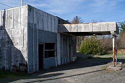
Former gas station in Sixes
USA Oregon location map.svg
Red pog.svg
Sixes
Location within the state of Oregon
Usa edcp location map.svg
Red pog.svg
Sixes
Sixes (the United States)
Coordinates: 42°49′13″N124°28′55″W / 42.82028°N 124.48194°W / 42.82028; -124.48194 Coordinates: 42°49′13″N124°28′55″W / 42.82028°N 124.48194°W / 42.82028; -124.48194
Country United States
State Oregon
County Curry
Time zone UTC-8 (Pacific (PST))
  Summer (DST) UTC-7 (PDT)
ZIP code
97476 [1]
Area code(s) 458 and 541

Sixes is an unincorporated community in Curry County, Oregon, United States. It is along U.S. Route 101 and the Sixes River, east of Cape Blanco and the Cape Blanco Lighthouse.

Contents

Accounts vary as to the origin of the name "Sixes". The community was named after the river. One local postmaster said Sixes was named for a Native American chief. Another source said that in 1851, the river was usually called the "Sikhs River" after the Chinook Jargon word for "friend", and on maps it was called the "Sequalchin River". Another source says the Native American name for the river was "Sa-qua-mi". Hodge's Handbook of American Indians says that one of the variants of the name of the local tribe, the Kwatami (a subdivision of the Tututni), was "Sik-ses-tene", which is said to mean "people by the far north country". Though this is most likely the real source of the name, the spelling "Sixes" was probably used by miners drawn to the Oregon gold rush who were familiar with the Chinook word "sikhs". The current spelling was used as early as 1855, and Sixes' post office was established in 1888. [2] The Sixes post office has since closed.[ citation needed ]

See also

Related Research Articles

<span class="mw-page-title-main">Lincoln City, Oregon</span> City in Oregon, United States

Lincoln City is a city in Lincoln County on the Oregon Coast of the United States, between Tillamook and Newport. It is named after the county, which was named in honor of former U.S. President Abraham Lincoln. The population was 9,815 at the 2020 Census.

Chinook Jargon is a language originating as a pidgin trade language in the Pacific Northwest. It spread during the 19th century from the lower Columbia River, first to other areas in modern Oregon and Washington, then British Columbia and parts of Alaska, Northern California, Idaho and Montana while sometimes taking on characteristics of a creole language. It is partly descended from the Chinook language, upon which much of its vocabulary is based. Approximately 15 percent of its lexicon is French, and it also makes use of English loanwords and those of other language systems. Its entire written form is in the Duployan shorthand developed by French priest Émile Duployé.

<span class="mw-page-title-main">Chinookan peoples</span> Group of Indigenous people in the Pacific Northwest

Chinookan peoples include several groups of Indigenous people of the Pacific Northwest in the United States who speak the Chinookan languages. Since at least 4000 BCE Chinookan peoples have resided along the Lower and Middle Columbia River (Wimahl) from the river's gorge downstream (west) to the river's mouth, and along adjacent portions of the coasts, from Tillamook Head of present-day Oregon in the south, north to Willapa Bay in southwest Washington. In 1805 the Lewis and Clark Expedition encountered the Chinook Tribe on the lower Columbia.

<span class="mw-page-title-main">Cape Blanco (Oregon)</span>

Cape Blanco is a prominent headland on the Pacific Ocean coast of southwestern Oregon in the United States, forming the westernmost point in the state. Cape Blanco extends further west than any point of land in the contiguous United States except portions of the Olympic Peninsula in Washington, including Cape Alava, the true westernmost point. The cape is part of Cape Blanco State Park and is the location of the Cape Blanco Light, first lit in 1870.

<span class="mw-page-title-main">Sixes River</span> River in the United States

The Sixes River flows about 31 miles (50 km) through coastal forests in southwestern Oregon in the United States. It drains a rugged region of the Klamath Mountains along the Pacific north of Port Orford.

<span class="mw-page-title-main">Toketee Falls</span> Waterfall in Oregon, United States

Toketee Falls is a waterfall in Douglas County, Oregon, United States, on the North Umpqua River at its confluence with the Clearwater River. It is located approximately 58 miles (93 km) east of Roseburg near Oregon Route 138.

<span class="mw-page-title-main">Umatilla River</span> River in Oregon, United States

The Umatilla River is an 89-mile (143 km) tributary of the Columbia River in northern Umatilla County, Oregon, United States. Draining a basin of 2,450 square miles (6,300 km2), it enters the Columbia near the city of Umatilla in the northeastern part of the state. In downstream order, beginning at the headwaters, major tributaries of the Umatilla River are the North Fork Umatilla River and the South Fork Umatilla River, then Meacham, McKay, Birch, and Butter creeks.

<span class="mw-page-title-main">Comcomly</span>

Comcomly was a Native American leader of the Lower Chinook, a group of Chinookan peoples indigenous to the Pacific Northwest, who inhabited the area near Ilwaco, Washington. Concomly spoke Lower Chinook and was known for his skill with diplomacy and trade.

The origin of the name of the U.S. state of Oregon is unknown, and a subject of some dispute.

Camas Valley is an unincorporated community in Douglas County, Oregon, United States, in the valley of the same name. It is on Oregon Route 42, near the Middle Fork Coquille River.

Illahe is an unincorporated community and the site of a former post office in Curry County, Oregon, United States. Located along the Rogue River about 8 miles (13 km) upriver from Agness, the area was home to Takelma Indians, then to white and Karok settlers, before becoming part of a designated wilderness. In the 21st century, it is a stopping place for hikers, boaters, and other visitors. The area has a riverside lodge and a nearby campground, both named Illahe.

<span class="mw-page-title-main">Marial, Oregon</span> Unincorporated community in the state of Oregon, United States

Marial is an unincorporated community and the site of a former post office in Curry County, Oregon, United States. Located along the Rogue River about 48 miles (77 km) from its mouth on the Pacific Ocean, the area was home to Takelma Indians, then to white and Karok settlers, before becoming part of a designated wilderness. Buildings preserved at the Rogue River Ranch pioneer farm complex, listed on the National Register of Historic Places, represent the former center of Marial. Nearby are the Tucker Flat Campground and a riverside lodge named Marial.

Necanicum is an unincorporated community in Clatsop County, Oregon, United States. It is located approximately 13 miles southeast of Seaside on U.S. Route 26 in the Northern Oregon Coast Range, next to the Necanicum River. Necanicum Junction is about a mile east of the site of the former post office, at the intersection of U.S. 26 and Oregon Route 53. It is served by the Seaside post office.

Gravelford is an unincorporated community in Coos County, Oregon, United States. It is about 8 miles (13 km) northeast of Myrtle Point, at the confluence of the North Fork Coquille River and the East Fork Coquille River.

Siltcoos is an unincorporated community in Lane County, Oregon, United States. It is about 13 miles (21 km) south of Florence on the east shore of Siltcoos Lake.

The Tumtum River is a 9-mile (14 km) tributary of the Marys River in Benton and Lincoln counties in the U.S. state of Oregon. The river rises in the Central Oregon Coast Range west of Burnt Woods and passes through the communities of Burnt Woods and Blodgett. It then drains into the Marys River north of Alder.

<span class="mw-page-title-main">Sitkum, Oregon</span> Unincorporated community in the state of Oregon, United States

Sitkum is an unincorporated community in Coos County, Oregon, United States. It is about 27 miles north of Remote in the Southern Oregon Coast Range near the East Fork Coquille River. Sitkum is served by the Myrtle Point post office.

Kamela is an unincorporated community in Union County, Oregon, United States. It is located west of Interstate 84 about 20 miles northwest of La Grande.

Bakeoven is an unincorporated community in Wasco County, in the U.S. state of Oregon. It is southeast of Maupin and northwest of Shaniko along Bakeoven Creek, a tributary of the Deschutes River.

<span class="mw-page-title-main">Floras Lake</span> Body of water

Floras Lake is a natural 236-acre (96 ha) body of water on the southern Oregon Coast of the United States. Fed by four small tributaries from a basin of about 10 square miles (26 km2) in Curry County, it lies about 10 miles (16 km) north of Port Orford and 2 miles (3 km) west of U.S. Route 101. It was probably named for Fred Flora, a 19th-century settler and miner who lived nearby.

References

  1. "Sixes ZIP Code". zipdatamaps.com. 2022. Retrieved November 11, 2022.
  2. McArthur, Lewis A.; Lewis L. McArthur (2003) [1928]. Oregon Geographic Names (Seventh ed.). Portland, Oregon: Oregon Historical Society Press. ISBN   0-87595-277-1.