List of places with numeric names

Last updated

Contents

Sign in Hundred, WV, USA HundredWVASign.jpg
Sign in Hundred, WV, USA
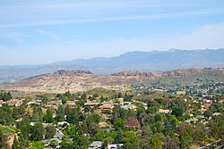
Thousand Oaks, a city in California was named after thousands of trees surrounding the area back in 1964 Mount-Clef-Ridge-Wildwood-Thousand-Oaks-Mountclef.jpg
Thousand Oaks, a city in California was named after thousands of trees surrounding the area back in 1964

Places that have numerals in their names include:

0

1/2 (half)

1

2

3

4

5

6

7

8

9

10

11

12

13

14

15

16

17

18

20

23

24

25

26

27

28

29

30

33

35

36

40

50

56

60

66

76

84

88

96

99

100

101

108

300

400

1,000

1,400

1,770

2,500

3,000

4,000

10,000

20,000

40,010

100,000

Names with trailing numbers

See also

Related Research Articles

<span class="mw-page-title-main">Chonburi province</span> Province of Thailand

Chonburi is a province of Thailand (changwat) located in eastern Thailand. Its capital is also named Chonburi. Neighbouring provinces are Chachoengsao, Chanthaburi, and Rayong, while the Bay of Bangkok is to the west. Pattaya, a major tourism destination in Thailand, is located in Chonburi, along with Laem Chabang, the country's primary seaport. The population of the province has grown rapidly and now totals 1.7 million residents, although a large portion of the population is floating or unregistered. The registered population as of 31 December 2018 was 1.535 million.

<span class="mw-page-title-main">Samut Prakan province</span> Province of Thailand

Samut Prakan province, Samut Prakan, or Samutprakan is one of the central provinces (changwat) of Thailand, established by the Act Establishing Changwat Samut Prakan, Changwat Nonthaburi, Changwat Samut Sakhon, and Changwat Nakhon Nayok, Buddhist Era 2489 (1946), which came into force 9 May 1946.

<span class="mw-page-title-main">Tripoint</span> Geographical point at which the boundaries of three countries or subnational entities meet

A triple border, tripoint, trijunction, triple point, or tri-border area is a geographical point at which the boundaries of three countries or subnational entities meet. There are 175 international tripoints as of 2020. Nearly half are situated in rivers, lakes or seas. On dry land, the exact tripoints may be indicated by markers or pillars, and occasionally by larger monuments.

<span class="mw-page-title-main">Bang Pakong River</span> River in Thailand

The Bang Pakong is a river in east Thailand. The river originates at the confluence of the Phra Prong River and the Hanuman River near Kabin Buri, Prachinburi Province. It empties after 231 kilometres into the Gulf of Thailand at the northeastern tip of the Bay of Bangkok. The watershed of the Bang Pakong is about 17,000 square kilometres (6,600 sq mi). The river powers a power station near its mouth, near Highway 7.

<span class="mw-page-title-main">Bang Rak district</span> District in Bangkok, Thailand

Bang Rak is one of the fifty districts (khet) of Bangkok, Thailand. It lies on the eastern bank of the Chao Phraya River, beyond Khlong Phadung Krung Kasem, which marked the old city boundary. Originating from riverside settlements dating from before the city's foundation, Bang Rak grew inland as new roads and canals were constructed through the area during the second half of the nineteenth century and the early twentieth, attracting communities of expatriates and developing into a major commercial district. Bangkok's rapid economic growth in the late twentieth century saw the areas along Si Lom and Sathon roads transformed into one of the city's main business districts, teeming with skyscrapers. The district, officially recognised at least since 1908, covers an area of 5.54 square kilometres (2.14 sq mi), and has a registered population of 48,227. Today, Bang Rak is known for the financial activity of its commercial offices, as well as its vibrant nightlife scenes. Diverse historic and religious sites, most significantly concentrated in Bang Rak Subdistrict on the waterfront, reflect the district's multicultural history.

Thailand is a unitary state in Southeast Asia. The administrative services of the executive branch of the government are regulated by the National Government Organisation Act, BE 2534 (1991). Under this Act, the services are divided into three levels: central, provincial and local.

<span class="mw-page-title-main">Kaeng Khoi district</span> District in Saraburi, Thailand

Kaeng Khoi is a district (amphoe) of Saraburi province in central Thailand. Located on the bank of the Pa Sak River amid the surrounding hills of the Dong Phaya Yen Mountains, its main town of the same name developed throughout the 19th century, first as a trading post on the river and the passageway into the Northeast, then as a railway town when the Northeastern Railway was built through the town at the end of the century. Today, it has developed into a major industrial centre, especially of cement manufacturing.

<span class="mw-page-title-main">Khon San district</span> District in Chaiyaphum, Thailand

Khon San is the northernmost district (amphoe) of Chaiyaphum province, northeastern Thailand.

<span class="mw-page-title-main">Bang Phae district</span> District in Ratchaburi, Thailand

Bang Phae is a district (amphoe) in the eastern part of Ratchaburi province, western Thailand.

<span class="mw-page-title-main">Mueang Phitsanulok district</span> District in Phitsanulok, Thailand

Mueang Phitsanulok is the capital district of Phitsanulok province, lower northern region of Thailand.

<span class="mw-page-title-main">Ban Dung district</span> District in Udon Thani, Thailand

Ban Dung is a district (amphoe) in northeastern Udon Thani province, Isan, Thailand.

<span class="mw-page-title-main">Wang Sam Mo district</span> District in Udon Thani, Thailand

Wang Sam Mo is a district (amphoe) in southeastern Udon Thani province, northeastern Thailand.

<span class="mw-page-title-main">Bueng Kan province</span> Province of Thailand

Bueng Kan, also spelled Bung Kan, is the 76th province (changwat) of Thailand, established by the Act Establishing Changwat Bueng Kan, BE 2554 (2011) on 23 March 2011. The province, consisting of the districts (amphoe) partitioned off Nong Khai province, lies in upper northeastern Thailand also called Isan. It is named after its central district, Mueang Bueng Kan.

<span class="mw-page-title-main">Windows Spotlight</span> Wallpaper image application

Windows Spotlight is a feature included with Windows 10 and Windows 11 which downloads images and advertisements from Bing and displays them as background wallpapers on the lock screen. In 2017, Microsoft began adding location information for many of the photographs.

<span class="mw-page-title-main">Kho Laen</span> Subdistrict in Thailand

Kho Laen is a tambon (subdistrict) located in the northeastern region of Buntharik district, in Ubon Ratchathani Province, Thailand. In 2021, it had a population of 13,260 people. Neighbouring subdistricts are Phon Ngam, Nong Sano, Ban Maet, and Non Ko, as well as the Champassack district of Laos in the east.

<span class="mw-page-title-main">Kao Kham, Nam Yuen</span> Subdistrict in Thailand

Kao Kham is a tambon (subdistrict) located in the northern region of Nam Yuen district, in Ubon Ratchathani Province, Thailand. It previously was a village in tambon Yang but gained tambon status in 1993.

Tha Chang is a tambon (subdistrict) in Chaloem Phra Kiat district, Nakhon Ratchasima province, Thailand.

References

  1. Einsiedelei (Graz) [ circular reference ]
  2. ข้อมูลประวัติความเป็นมาและข้อมูลสําคัญต่างๆของอําเภอสอง จากเว็บไซต์จังหวัดแพร่ (in Thai)
  3. ประวัติอำเภอสองแคว จากเว็บไซต์สำนักงานวัฒนธรรมจังหวัดน่าน (in Thai)
  4. ประวัติอำเภอ จากเว็บไซต์สำนักงานเกษตรอำเภอสามชัย (in Thai)
  5. ประวัติความเป็นมา จากเว็บไซต์สำนักงานพัฒนาชุมชนอำเภอสามง่าม จังหวัดพิจิตร กรมการพัฒนาชุมชน กระทรวงมหาดไทย (in Thai)
  6. ประวัติอำเภอสามเงา จากเว็บไซต์จังหวัดตาก (in Thai)
  7. U.S. Geological Survey Geographic Names Information System: List of places with numeric names
  8. ประวัติอำเภอเก้าเลี้ยว จากเว็บไซต์สำนักงานพัฒนาชุมชนอำเภอเก้าเลี้ยว จังหวัดนครสวรรค์ กรมการพัฒนาชุมชน กระทรวงมหาดไทย (in Thai)
  9. ข้อมูลอำเภอเก้าเลี้ยว จากเว็บไซต์สำนักงานเกษตรอำเภอเก้าเลี้ยว (in Thai)