Carpenterville, Oregon

Last updated
Carpenterville, Oregon
USA Oregon location map.svg
Red pog.svg
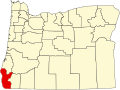
Carpenterville
Location within the state of Oregon
Usa edcp location map.svg
Red pog.svg
Carpenterville
Carpenterville (the United States)
Coordinates: 42°13′13″N124°20′18″W / 42.22028°N 124.33833°W / 42.22028; -124.33833 Coordinates: 42°13′13″N124°20′18″W / 42.22028°N 124.33833°W / 42.22028; -124.33833
Country United States
State Oregon
County Curry
Established1932
Time zone UTC-8 (Pacific (PST))
  Summer (DST) UTC-7 (PDT)
ZIP code
97415
Area code(s) 458 and 541

Carpenterville is an unincorporated community in Curry County, Oregon, United States. [1] It is located on the former alignment of U.S. Route 101 known as the Roosevelt Highway (now Oregon Route 255 or the Carpenterville Highway), about 16 miles north of Brookings. [2] [3] Carpenterville was the highest point on the former main coastal highway and the area is known for its views. [3] [4] [5]

Contents

D. W. Carpenter and his family settled in the area in 1921. The family ran a sawmill that produced lumber for fences. [2] Carpenterville post office was established in 1932 and named for the Carpenter family. [2] In 1940, Carpenterville's population was 35. [4] The post office closed in 1944. [2] When Carpenterville was still on the main route of the Coast Highway, there was a public school, a store, tourist cabins, and a lodge, the Skyline Lodge and Restaurant. [3] [5] The realignment of the highway cut the community off from the main coastal road. [3] By 1990, there was only one house to mark the location of the community, however the USGS still classifies Carpenterville as a populated place. [5]

The Carpenter Family is still very much active in the Carpenterville area. Zed Carpenter, Brodey Carpenter, Rocky Carpenter, Alvin Carpenter, Rodney Carpenter and many more.

See also

Related Research Articles

<span class="mw-page-title-main">Wedderburn, Oregon</span> Unincorporated community in the state of Oregon, United States

Wedderburn is an unincorporated coastal community in Curry County, Oregon, United States. It is to the north of, and across the mouth of the Rogue River from Gold Beach, on U.S. Route 101. The Isaac Lee Patterson Bridge connects Wedderburn with Gold Beach.

<span class="mw-page-title-main">Bull Run, Oregon</span> Unincorporated community in the state of Oregon, United States

Bull Run is an unincorporated community in Clackamas County, Oregon, United States. It is located about 5 miles (8.0 km) northeast of Sandy, near the Bull Run River and the powerhouse of the defunct Mount Hood Railway and Power Company.

<span class="mw-page-title-main">Lake of the Woods, Oregon</span> Unincorporated community in the state of Oregon, United States

Lake of the Woods is an unincorporated community in Klamath County, Oregon, United States. It is located on the east shore of the lake of the same name within the Winema National Forest, about a mile south of Oregon Route 140.

<span class="mw-page-title-main">Manhattan Beach State Recreation Site</span>

Manhattan Beach State Recreation Site is a state park in the U.S. state of Oregon. Administered by the Oregon Parks and Recreation Department, the park is open to the public and is fee-free. Amenities at the park, which is 2 miles (3 km) north of Rockaway Beach along U.S. Route 101, include picnicking, fishing, and a Pacific Ocean beach.

<span class="mw-page-title-main">Horton, Oregon</span> Unincorporated community in the state of Oregon, United States

Horton is an unincorporated community in Lane County, Oregon, United States. It is about three miles northeast of Blachly, in the Lake Creek valley of the Central Oregon Coast Range.

<span class="mw-page-title-main">Dolph, Oregon</span> Unincorporated community in the state of Oregon, United States

Dolph is an unincorporated community in Tillamook County, Oregon, United States, near the Yamhill County line. It lies at the junction of Oregon Route 22 and Oregon Route 130 between Grande Ronde and Hebo, on the Little Nestucca River. It is within the Siuslaw National Forest in the Northern Oregon Coast Range.

Denmark is an unincorporated community in Curry County, Oregon, United States, between Bandon and Port Orford where U.S. Route 101 crosses Willow Creek.

Riverton is an unincorporated community in Coos County, Oregon, United States, on Oregon Route 42S, about 12 miles (19 km) up the Coquille River from Bandon. Route 42S is the former alignment of U.S. Route 101.

Necanicum is an unincorporated community in Clatsop County, Oregon, United States. It is located approximately 13 miles southeast of Seaside on U.S. Route 26 in the Northern Oregon Coast Range, next to the Necanicum River. Necanicum Junction is about a mile east of the site of the former post office, at the intersection of U.S. 26 and Oregon Route 53. It is served by the Seaside post office.

<span class="mw-page-title-main">Hauser, Oregon</span> Unincorporated community in the state of Oregon, United States

Hauser is an unincorporated community in Coos County, Oregon, United States. It is along U.S. Route 101, 7 miles (11 km) south of Lakeside and 6 miles (10 km) north of North Bend. Hauser is on the edge of the Oregon Dunes National Recreation Area near North Slough, a tributary of Coos Bay once known as the North Inlet of Coos Bay. It is a station on the Central Oregon and Pacific Railroad.

Cecil is an unincorporated community in Morrow County, Oregon, United States. It is about 14 miles (23 km) northwest of Ione, on Oregon Route 74. The Oregon Trail crossed Willow Creek here, and it was once an important stagecoach stop.

Walker is an unincorporated community in Lane County, Oregon, United States. It is located about 4 miles (6 km) north of Cottage Grove on Oregon Route 99, near the Coast Fork Willamette River.

Bridge is an unincorporated community in Coos County, Oregon, United States. It is about 9 miles (14 km) east of Myrtle Point on Oregon Route 42 near the Middle Fork Coquille River.

Burnt Woods is an unincorporated community in Lincoln County, Oregon, United States. It is located about 16 miles (26 km) west of Philomath on U.S. Route 20 in the Central Oregon Coast Range near the Tumtum River.

<span class="mw-page-title-main">Rocky Point, Oregon</span> Unincorporated community in the state of Oregon, United States

Rocky Point is an unincorporated community in Klamath County, Oregon, United States. It is on Pelican Bay on the west shore of Upper Klamath Lake, about 29 miles (47 km) northwest of Klamath Falls and about 3 miles (5 km) north of Oregon Route 140 on Forest Highway 34. It is within the Winema National Forest.

<span class="mw-page-title-main">Pistol River</span> River in Oregon, United States

The Pistol River is a coastal stream that meanders for 21 miles (34 km) through the Southern Oregon Coast Range to the Pacific Ocean near the unincorporated community of Pistol River in the U.S. state of Oregon. Flowing generally southwest from its origin near Sugarloaf Mountain in the Siskiyou National Forest, the river enters the sea at Pistol River State Scenic Viewpoint, 10 miles (16 km) south of Gold Beach. The river received its name after pioneer James Mace lost his pistol in it in 1853.

<span class="mw-page-title-main">Buchanan, Oregon</span> Unincorporated community in the state of Oregon, United States

Buchanan is an unincorporated community in Harney County, Oregon, United States. It is about 20 miles (32 km) east of Burns on U.S. Route 20.

<span class="mw-page-title-main">Thatcher, Oregon</span>

Thatcher is an unincorporated historic community in Washington County, Oregon, United States. It was located approximately three miles north of Forest Grove at the intersection of Hillside and Thatcher roads. The area is part of the Forest Grove Rural Fire Protection District.

Lees Camp is an unincorporated community in Tillamook County, Oregon, United States. It is along Oregon Route 6 about 25 miles (40 km) northeast of Tillamook at the confluence of the Wilson River and North Fork Wilson River, surrounded by the Tillamook State Forest. It is near the summit of the Northern Oregon Coast Range.

Blalock was an unincorporated community located in the Columbia River Gorge in Gilliam County, Oregon, United States. The town displaced a Native American settlement originally named Táwash. Blalock was located about 7 miles (11 km) west of Arlington on Interstate 84/U.S. Route 30 at the mouth of Blalock Canyon. Blalock is still the name of a station on the Union Pacific Railroad.

References

  1. "Carpenterville". Geographic Names Information System . United States Geological Survey, United States Department of the Interior. November 28, 1980. Retrieved April 23, 2014.
  2. 1 2 3 4 McArthur, Lewis A.; McArthur, Lewis L. (2003) [1928]. Oregon Geographic Names (7th ed.). Portland, Oregon: Oregon Historical Society Press. pp. 169–170. ISBN   978-0875952772.
  3. 1 2 3 4 Boice, Meryl (2012). Gold Beach and South Curry County. Images of America. Arcadia Publishing. p. 30. ISBN   978-0-7385-9615-0.
  4. 1 2 "A 1940 Oregon Coast Tour: Port Orford to California Line". Oregon State Archives . Retrieved April 23, 2014.
  5. 1 2 3 Friedman, Ralph (1990). In Search of Western Oregon. Caldwell, Idaho: The Caxton Printers, Ltd. p. 110. ISBN   0-87004-332-3.