
University of Illinois Willard Airport is south of Savoy in Tolono Township, Champaign County, Illinois, United States. It is owned and operated by the University of Illinois Urbana–Champaign and is named for former University of Illinois president Arthur Cutts Willard.

Central Illinois Regional Airport at Bloomington–Normal is a public airport in McLean County, Illinois, three miles east of Bloomington and southeast of Normal. Owned by the Bloomington–Normal Airport Authority, it is also known as Central Illinois Regional Airport (CIRA).

Chicago Executive Airport, formerly Palwaukee Municipal Airport, is a public airport 18 miles (33 km) northwest of Chicago, in the village of Wheeling in Cook County, Illinois, United States. It is owned by the City of Prospect Heights and the Village of Wheeling.
Shelby County Airport is a public airport located three miles (4.8 km) west of the central business district (CBD) of Shelbyville, a city in Shelby County, Illinois, United States. A significant amount of the airport's traffic is from agricultural aviation serving nearby areas.

Jackson County Airport, also known as Reynolds Field, is a county-owned, public-use airport located two nautical miles (3.7 km) west of the central business district of Jackson, in Jackson County, Michigan, United States. It is a class D airport with operating control tower. It is included in the Federal Aviation Administration (FAA) National Plan of Integrated Airport Systems for 2017–2021, in which it is categorized as a regional general aviation facility.
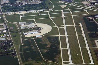
DuPage Airport is a general aviation airport located 29 miles (47 km) west of downtown Chicago in West Chicago, DuPage County, Illinois, United States. It is owned and operated by the DuPage Airport Authority, which is an independent government body established by law by the state of Illinois. It also serves as a relief airport for O'Hare International Airport and Chicago Midway International Airport, both in nearby Chicago.
Branch County Memorial Airport is a county-owned, public-use airport located three nautical miles (6 km) west of the central business district of Coldwater, a city in Branch County, Michigan, United States. It is included in the Federal Aviation Administration (FAA) National Plan of Integrated Airport Systems for 2017–2021, in which it is categorized as a local general aviation facility.

Southern Illinois Airport is a public airport in Jackson County, Illinois, United States. It is located three nautical miles (6 km) northwest of the central business district of Carbondale and east of Murphysboro. This airport is included in the FAA's National Plan of Integrated Airport Systems for 2025–2029, which categorized it as a regional general aviation facility.

Nanwalek Airport is a state-owned public-use airport located in Nanwalek, an unincorporated community in the Kenai Peninsula Borough of the US state of Alaska. It was formerly known as English Bay Airport.

Clare Municipal Airport is a public airport located one mile (2 km) east of downtown Clare, a city in Clare County, Michigan, United States. The airport became active in 1941. It serves general aviation for Clare and the surrounding area. It is included in the Federal Aviation Administration (FAA) National Plan of Integrated Airport Systems for 2017–2021, in which it is categorized as a local general aviation facility.

Canton–Plymouth Mettetal Airport is a public use airport located in Canton Township, Michigan, United States. The airport lies two nautical miles (3.7 km) south of the central business district of Plymouth, in Wayne County. The airport is owned and operated by the Michigan Department of Transportation (MDOT). It is also referred to as Mettetal Airport. The airport is uncontrolled (non-towered), and is used for general aviation purposes.
Dowagiac Municipal Airport is a public airport owned and operated by the City of Dowagiac located 1m (1.6 km) northwest of Dowagiac, Michigan, United States. The uncontrolled airport is used for general aviation purposes. It is included in the Federal Aviation Administration (FAA) National Plan of Integrated Airport Systems for 2017–2021, in which it is categorized as a local general aviation facility.
Anderson Municipal Airport is a public use airport three miles east of Anderson in Madison County, Indiana. The National Plan of Integrated Airport Systems for 2011–2015 categorized it as a general aviation facility. The airport currently has no scheduled air service however, is one of the busiest general aviation airports in the State of Indiana given its high volume of flight training and charter traffic.

Joliet Regional Airport is a public use airport located four nautical miles (7 km) west of the central business district of Joliet, a city in Will County, Illinois, United States. It is owned by the Joliet Park District.

Clinton Field is a public use airport located four nautical miles northwest of the central business district of Wilmington, a city in Clinton County, Ohio, United States. It is owned by the Clinton County Board of Commissioners. This airport is included in the FAA's National Plan of Integrated Airport Systems (2009-2013), which categorizes it as a general aviation facility.

Grimes Field is a city-owned public-use airport located one nautical mile (1.85 km) north of the central business district of Urbana, a city in Champaign County, Ohio, United States. The airport is named after Warren G. Grimes, a forefather in the field of aviation lighting, and his Grimes Manufacturing Company operated the airport until 1987. It primarily serves general aviation traffic. Although it is owned by the City of Urbana, Grimes Field is self-supporting.
Centralia Municipal Airport is a U.S. general aviation airport located two nautical miles southeast of Centralia, Illinois.
The Dacy Airport is a privately owned, public-use airport located 1 mile southwest of Harvard, Illinois, United States.
Sparta Community Airport, also known as Hunter Field, is a civil, public use airport 2 miles north of Sparta in Randolph County, Illinois, United States. It is publicly owned by the Sparta Community Airport Authority.
Oceana County Airport is a public use airport located between the cities of Hart and Shelby, Michigan. It is publicly owned by the Oceana County Court House.


