Matšitšileng, also known as Wisconcin, is a village Next to Ga-Mathapo(Ga-Matlala) in the Mogalakwena Local Municipality of the Waterberg District Municipality of the Limpopo province of South Africa. It is situated about 110 km northwest of Polokwane and Mokopane.
Alexandria is a town in Bushbuckridge Local Municipality under Ehlanzeni District Municipality in the Mpumalanga province of South Africa. Its got its theme of footprints on rock in the mountains of Simeleni. It borders two rivers Bhejane and Ngwenyameni that connect with the giant Sabie River. It is the birthplace of well-known businessmen Moses Tibane, Solly Ndlovu, Petrus Sydney Mabuza "Mshengu" and Welcome Matsane, also the birthplace of the South African drone sketch drawing and electrician ( ), the former Executive Mayor of Bushbuckridge Renias Khumalo and late struggle icons such as Kaizer Mgiba, as well as Victor Mkhonto. This village is under the leadership of Mathibela Traditional Council led by Kgoshi Lameck Mokoena who is also a Congress of Traditional Leaders of South Africa President.
Kalkspruit is a large village in Ga-Mashashane in the Polokwane Local Municipality Capricorn District Municipality in the Limpopo province of South Africa. The village is located on the Matlala Road about 30km west of the city of Polokwane.
Ga-Sebotse, also known as Pinkie, is a large village in Ga-Matlala in the Blouberg Local Municipality of the Capricorn District Municipality of the Limpopo province of South Africa. It is located 73 km northwest of Polokwane and 37 km southwest of Senwabarwana.
Tibane, also known as Tibanefontein, is a large, sprawling village in Ga-Matlala in the Polokwane Local Municipality of the Capricorn District Municipality of the Limpopo province of South Africa. It is located 55 km northwest of the city of Polokwane on the intersection between the R567 and Matlala roads.
Ga-Ngwetšana, also known as Ceres, is a large village in Moletši in the Polokwane Local Municipality of the Capricorn District Municipality in the Limpopo province of the Republic of South Africa. It is located about 45 km northwest of the City of Polokwane on the R567 road.
Setumong is a large village in the Polokwane Local Municipality of the Capricorn District Municipality in the Limpopo province of South Africa. It is the capital of the Ga-Matlala tribal chieftaincy and headquarters the Bakone Traditional Council. It located about 48 km northwest of the city of Polokwane on the Matlala Road.
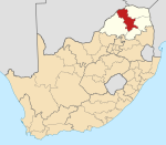
Mamehlabe is a large village in Ga-Matlala in the Blouberg Local Municipality of the Capricorn District Municipality of the Limpopo province of South Africa. It is located about 10 km northwest of Tibane on the Matlala Road.
Ga-Mokobodi is a village in Ga-Matlala in the Blouberg Local Municipality of the Capricorn District Municipality of the Limpopo province of South Africa. It is located about 5 km northwest of Tibane.
Ga-Lepadima is a village in Ga-Matlala in the Blouberg Local Municipality of the Capricorn District Municipality of the Limpopo province of South Africa. It is located a mere 2 km north of Tibane on the Matlala Road.
Juno is a village in Ga-Matlala in the Polokwane Local Municipality of the Capricorn District Municipality of the Limpopo province of South Africa. It is located a mere 1,5 km northeast of Tibane on the R567 road.
Ga-Ramalapa is a large village in Ga-Matlala in the Polokwane Local Municipality of the Capricorn District Municipality of the Limpopo province of South Africa. It is located 47 km northwest of Polokwane.
Kordon is a village in Ga-Matlala in the Polokwane Local Municipality of the Capricorn District Municipality of the Limpopo province of South Africa. It is located 47 km northwest of Polokwane on the Matlala Road.
Ga-Ramakara is a village in Ga-Matlala in the Polokwane Local Municipality of the Capricorn District Municipality of the Limpopo province of South Africa. It is located 44 km northwest of Polokwane on the Matlala Road.
Ga-Mahoai is a large village in Ga-Matlala in the Polokwane Local Municipality of the Capricorn District Municipality of the Limpopo province of South Africa. It is located 49 km northwest of Polokwane.
Ngwanallela is a village in Ga-Matlala in the Blouberg Local Municipality of the Capricorn District Municipality of the Limpopo province of South Africa. It is located about 19 km northwest of Tibane and 40 km east of Steilloopbrug.
Ga-Tšhipana is a village in Ga-Matlala in the Mogalakwena Local Municipality of the Waterberg District Municipality of the Limpopo province of South Africa. It is located 69 km northwest of the city Polokwane.
Ga-Lamola, also known as Rosenkrantz Farm, is a sparsely populated village in Ga-Matlala in the Blouberg Local Municipality of the Capricorn District Municipality of the Limpopo province of South Africa. It is located 73 km northwest of Polokwane and 32 km southeast of Senwabarwana.
Ga-Ramela is a large village in Ga-Matlala in the Mogalakwena Local Municipality of the Waterberg District Municipality of the Limpopo province of South Africa. It is located 80 km northwest of Polokwane on the Matlala Road.
Lekhureng is a large village in Ga-Matlala in the Mogalakwena Local Municipality of the Waterberg District Municipality of the Limpopo province of South Africa. It is located 79 km northwest of the city of Polokwane