Pretoria is South Africa's administrative capital, serving as the seat of the executive branch of government, and as the host to all foreign embassies to South Africa.

Squirrels are members of the family Sciuridae, a family that includes small or medium-size rodents. The squirrel family includes tree squirrels, ground squirrels, and flying squirrels. Squirrels are indigenous to the Americas, Eurasia, and Africa, and were introduced by humans to Australia. The earliest known fossilized squirrels date from the Eocene epoch, and among other living rodent families, the squirrels are most closely related to the mountain beaver and to the dormice.

Eucalyptus is a genus of more than 700 species of flowering plants in the family Myrtaceae. Most species of Eucalyptus are trees, often mallees and a few are shrubs. Along with several other genera in the tribe Eucalypteae, including Corymbia and Angophora, they are commonly known as eucalypts. Plants in the genus Eucalyptus have bark that is either smooth, fibrous, hard or stringy, the leaves have oil glands, and the sepals and petals are fused to form a "cap" or operculum over the stamens. The fruit is a woody capsule commonly referred to as a "gumnut".

The kola nut is the seed of certain species of plant of the genus Cola, placed formerly in the cocoa family Sterculiaceae and now usually subsumed in the mallow family Malvaceae. These cola species are trees native to the tropical rainforests of Africa. Their caffeine-containing seeds are about 5 centimetres (2.0 in) across and are used as flavoring ingredients in beverages applied to various carbonated soft drinks, from which the name cola originates.
The Lugbara live in the Democratic Republic of the Congo, Uganda, and South Sudan. In Lugbara mythology, Adroa appeared in both good and evil aspects; he was the creator god and appeared on Earth as a man who was near death. He was depicted as a very tall white man with only one half of a body, missing one eye, one leg, etc. His children were called the Adroanzi.

Erythrina is a genus of plants in the pea family, Fabaceae. It contains about 130 species, which are distributed in tropical and subtropical regions worldwide. They are trees, with the larger species growing up to 30 m (98 ft) in height. The generic name is derived from the Greek word ερυθρóς erythros, meaning "red", referring to the flower color of certain species.
Kirstenbosch is an important botanical garden nestled at the eastern foot of Table Mountain in Cape Town. The garden is one of 10 National Botanical Gardens covering five of South Africa's six different biomes and administered by the South African National Biodiversity Institute (SANBI). Prior to 1 September 2004, the institute was known as the National Botanical Institute.

Kroonstad, officially named Maokeng, is the fourth largest town in the Free State and lies two hours' drive on the N1 from Gauteng. It is the second-largest commercial and urban centre in the Northern Free State, and an important railway junction on the main line from Cape Town to Johannesburg. Maokeng is Sesotho and means "place of the thorn trees ".
Hyde Park is a very wealthy suburb of Johannesburg, South Africa. It borders Illovo, Sandhurst, and Craighall Park. Hyde Park is located in Region B of the City of Johannesburg Metropolitan Municipality.
Forest Hill is a suburb of Johannesburg, South Africa. It is located in Region F of the City of Johannesburg Metropolitan Municipality.
Pinelands is an affluent garden city suburb located on the edge of the southern suburbs of Cape Town, South Africa, neighbouring the suburb of Thornton, and is known for its large thatched houses and green spaces. The suburb is primarily residential and is often praised for its peacefulness and abundance of trees. Pinelands is one of the few areas in Cape Town in which sale of alcohol to the public is prohibited, but some clubs have private liquor licenses. It is a popular place for senior citizens to retire to. While there are several retirement homes in the suburb, younger people are increasingly moving in.
Craighall is a suburb of Johannesburg, South Africa and is bordered by Hyde Park, Dunkeld and Parkhurst. It sits in between the busy arterial routes of Jan Smuts Avenue and William Nicol highway and is located in Region B of the City of Johannesburg Metropolitan Municipality.
Fellside is a suburb of Johannesburg, South Africa. It is a small suburb located north-east of the city centre with Orange Grove to its north, south and east, with Houghton Estate to its west. It is located in Region E of the City of Johannesburg Metropolitan Municipality.
Melrose Estate is a suburb of Johannesburg, South Africa. It is located in Region 3. Until the early 2000s, the suburb had many fine traditional houses, which are rapidly giving way to cluster house complexes. While probably inevitable, this is slowly defacing the suburb. With the expected building of the Gautrain station in nearby Rosebank, the suburb is likely to disappear as a tree-covered residential area.

Entandrophragma cylindricum is a tree of the genus Entandrophragma of the family Meliaceae. It is commonly known as sapele or sapelli or sapele mahogany, as well as aboudikro, assi, and muyovu.
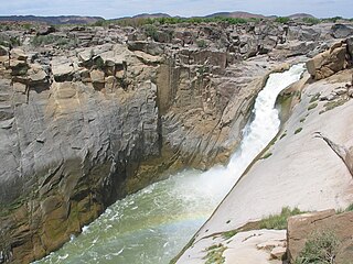
Augrabies Falls National Park is a national park located around the Augrabies Falls, about 120 km west of Upington in the Northern Cape Province, South Africa.
Edgemead is one of the Northern Suburbs of Cape Town. It is one of several garden cities of South Africa, the first being Pinelands in the southern suburbs. Edgemead is mainly residential, and as the name 'garden city' suggests, is noted for its trees, gardens and generally pleasant environment. Other 'garden cities' that have followed are Pinehurst near Durbanville on the northwestern outskirts of the Cape Metropole, still under construction but already occupied, and Sunningdale near Milnerton.

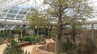
Adansonia digitata, the African baobab, is the most widespread tree species of the genus Adansonia, the baobabs, and is native to the African continent and the southern Arabian Peninsula. These are long-lived pachycauls; radiocarbon dating has shown some individuals to be over 2,000 years old. They are typically found in dry, hot savannas of sub-Saharan Africa, where they dominate the landscape and reveal the presence of a watercourse from afar. They have traditionally been valued as sources of food, water, health remedies or places of shelter and are a key food source for many animals. They are steeped in legend and superstition. In recent years, many of the largest, oldest trees have died, for unknown reasons. Common names for the baobab include monkey-bread tree, upside-down tree, and cream of tartar tree.
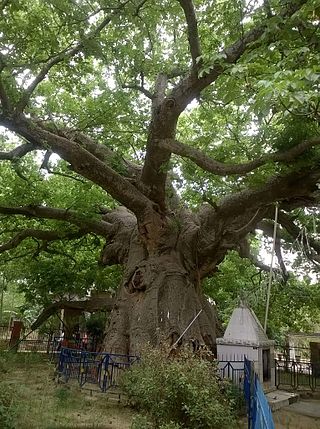
The Parijaat tree is a sacred baobab tree in the village of Kintoor, near Barabanki, Uttar Pradesh, India, about which there are several legends.
A landmark is a recognizable natural or artificial feature used for navigation, a feature that stands out from its near environment and is often visible from long distances.