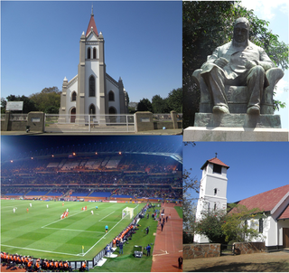
Polokwane, also known as Pietersburg, is a city and the capital of the Limpopo Province of South Africa. It is South Africa's largest urban centre north of Gauteng. It was one of the host cities of the 2010 FIFA World Cup.

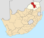
Limpopo is the northernmost province of South Africa. It is named after the Limpopo River, which forms the province's western and northern borders. The capital and largest city in the province is Polokwane, while the provincial legislature is situated in Lebowakgomo.
Secunda is a town built amidst the coalfields of the Mpumalanga province of South Africa. It was named for being the second Sasol extraction refinery producing oil from coal, after Sasolburg, some 140 kilometres (87 mi) to the west.

Newcastle is the third-largest city in the province of KwaZulu-Natal, South Africa and is the province's industrial centre. The city has four industrial areas. Newcastle is known as the "City of Industries" The majority of its citizens reside in Newcastle East in the main townships of Madadeni and Osizweni, with the balance residing in Newcastle West. Set at the foothills of the northern KwaZulu-Natal Drakensberg Mountains, Newcastle is located in the northwest corner of the province along the Ncandu River.

Krugersdorp is a mining city in the West Rand, Gauteng Province, South Africa founded in 1887 by Marthinus Pretorius and Abner Cohen. Following the discovery of gold on the Witwatersrand, a need arose for a major town in the west of the reef. The government bought part of the Paardekraal farm and named the new town after the Transvaal president, Paul Kruger. Krugersdorp no longer has a separate municipal government after it was integrated into Mogale City Local Municipality along with surrounding towns. It is now the seat of government for Mogale City.
Bela-Bela, also known by its original name Warmbaths. is a town in the Limpopo Province of South Africa. Deriving its name from the geothermic hot springs around which the town was built.
Rustenburg is a city at the foot of the Magaliesberg mountain range. Rustenburg is the most populous city in North West province, South Africa. In 2017, the city's Gross Domestic Product (GDP) reached ZAR 63.8 billion, accounting for 21.1% of the GDP of the North West Province, and 1.28% of the GDP of South Africa. Rustenburg was one of the official host cities of the 2010 FIFA World Cup, being in close proximity to Phokeng, the capital of the Royal Bafokeng Nation, where the Royal Bafokeng Stadium is located. The England national football team also used this as their base camp for the tournament.

The Independent Examinations Board, or IEB, is a South African independent assessment agency which offers examinations for various client schools, mostly private schools. It is most prominent in setting examinations for the school-leaving National Senior Certificate, or NSC for its client schools. See High school: South Africa; Matriculation in South Africa.
Giyani is a town situated in the North-eastern part of Limpopo Province, South Africa. It is the administrative capital of the Mopani District Municipality, and a former capital of the defunct Gazankulu bantustan. The town of Giyani has seven sections: Section A, Section D1, Section D2, Section E, Section F, Kremetart, and Giyani CBD. Risinga View and Church View are new residential areas in Giyani, but fall under local Traditional Leaders. The Giyani CBD is nicknamed Benstore, and this name is commonly used by residents of the region. Giyani is surrounded by a number of villages with rich Tsonga cultural activities, administered by the Greater Giyani Local Municipality.

Somerset West is a town in the Western Cape, South Africa. Organisationally and administratively it is included in the City of Cape Town metropolitan municipality as a suburb of the Helderberg region . The vehicle registration code for Somerset West is CFM and the post code is 7130 for street addresses, and 7129 for post office boxes.

Brackenfell is a railway town in the Western Cape province of South Africa and a northern suburb of Cape Town. It lies at the gateway to the Cape Winelands approximately halfway between Cape Town – 30 km and Paarl – 35 km.

Durbanville is a town in the Western Cape province of South Africa, part of the greater Cape Town metropolitan area. Durbanville is a semi-rural residential suburb on the north-eastern outskirts of the metropolis and in the midst of farms producing wine and wheat.

Durban North is an area to the north of Durban in the eThekwini Metropolitan Municipality, KwaZulu-Natal, South Africa. Durban North lies between the N2 freeway and the eastern seashore, with the Umgeni River forming its southern boundary. It has residential suburbs that are some of Durban's most affluent and is flanked by La Lucia in the north.

Salt Rock is a small coastal village just north of Ballito and Shaka's Rock situated along the Dolphin Coast of KwaZulu-Natal, South Africa. It is a favorite holiday destination for many local South Africans. It is approximately located 52 kilometres north-east of Durban and 19 km south-east of KwaDukuza. Salt Rock owes much of its history to Basil Hulett and his wife Gwen who started not only the Salt Rock Hotel but went on to develop the town of Salt Rock as found today.

Ottery is a suburb in Cape Town, South Africa. It is on the edge of the Southern Suburbs. The Youngsfield Military Base, Royal Cape Golf Club and Cape Town's 'official' China Town are located in the suburb. Every year the Youngsfield Military Base in Ottery hosts the Cape Argus Junior Cycle Tour on 12 March.
Senwabarwana, also known as Bochum, is a town in the Blouberg Local Municipality of the Capricorn District Municipality in the Limpopo province of South Africa. The town is the seat of the Blouberg Local Municipality. It is located about 93 km northwest of the city Polokwane.
Polokwane United Football Club is a South African Association Football club based in Polokwane, South Africa, which competes in the SAB Regional League. The academy was established in 2012 however the club started competing in the SAFA Second Division during the 2014/15 season after purchasing the rights from Rospa United FC. The Club boasts its own training centre located on a 15 hectare plot in Makotopong, north east of Polokwane.
Setumong is a large village in the Polokwane Local Municipality of the Capricorn District Municipality in the Limpopo province of South Africa. It is the capital of the Ga-Matlala tribal chieftaincy and headquarters the Bakone Traditional Council. It located about 48 km northwest of the city of Polokwane on the Matlala Road.
Oslo Beach is a small beachside suburb located on the South Coast of KwaZulu-Natal, South Africa and forms part of the coastal town of Port Shepstone.

Mall of the North, is a super regional shopping mall situated in Bendor Park, Polokwane in the Limpopo province of South Africa. It has a mix of shops, restaurants and a cinema complex.