
Thaba Chweu Municipality is a local municipality within the Ehlanzeni District Municipality, in the Mpumalanga province of South Africa.

Mkhondo Municipality is a local municipality within the Gert Sibande District Municipality, in the Mpumalanga province of South Africa. Piet Retief is the seat of the municipality.

Lephalale Municipality is a local municipality within the Waterberg District Municipality, in the Limpopo province of South Africa. The seat is Lephalale.

Mogalakwena Municipality is a local municipality within the Waterberg District Municipality, in the Limpopo province of South Africa. It's named after the mogalakwena river which comes from the babina Kwena fierce Nile crocodile. The seat is Mokopane. The area constitute of a cosmopolitan of different chiefdoms : mainly bakone, Lebelo kgomo, transvaal Ndebele Langa & Kekana, phokela, Lekalekale, babirwa.

Mutale Local Municipality was a municipality located in the Vhembe District Municipality of Limpopo province, South Africa. The seat of Mutale Local Municipality was Mutale. It is now part of Thulamela and Musina Local Municipalities.

Musina Municipality is a local municipality within the Vhembe District Municipality, in the Limpopo province of South Africa. It is the northernmost local municipality in South Africa. It borders Botswana, Mozambique and Zimbabwe. The seat is Musina.

Maruleng Municipality is a local municipality within the Mopani District Municipality, in the Limpopo province of South Africa. The seat of the municipality is Hoedspruit.

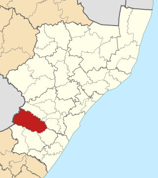
Greater Letaba Municipality is a local municipality within the Mopani District Municipality, in the Limpopo province of South Africa. The seat is Modjadjiskloof.

Elias Motsoaledi Municipality, formerly the Greater Groblersdal Municipality, is a local municipality within the Sekhukhune District Municipality, in the Limpopo province of South Africa. The seat of is Groblersdal. It is named in honour of the Elias Motsoaledi.

Emakhazeni Municipality formerly Highlands Municipality, is a local municipality within the Nkangala District Municipality, in the Mpumalanga province of South Africa. The seat is Belfast.

Greater Taung Municipality is a local municipality within the Dr Ruth Segomotsi Mompati District Municipality, in the North West province of South Africa. The seat of the municipality is Taung.

Metsimaholo Municipality is a local municipality within the Fezile Dabi District Municipality, in the Free State province of South Africa. Metsimaholo means "big water" in Sesotho.

Newcastle Municipality is a local municipality within the Amajuba District Municipality, in the KwaZulu-Natal province of South Africa.

Kwa Sani Local Municipality was an administrative area in the Harry Gwala of KwaZulu-Natal in South Africa.

uMdoni Municipality is a local municipality within the Ugu District Municipality, in the KwaZulu-Natal province of South Africa. uMdoni is the isiZulu name for the indigenous forest waterberry plant.

Phumelela Municipality is a local municipality within the Thabo Mofutsanyane District Municipality, in the Free State province of South Africa. Phumelela means "to succeed" in isiZulu.

Mpofana Municipality is a local municipality within the Umgungundlovu District Municipality, in the KwaZulu-Natal province of South Africa.

Setsoto Municipality is a local municipality within the Thabo Mofutsanyane District Municipality, in the Free State province of South Africa. Setsoto is a Sesotho word meaning "beauty". The seat is Ficksburg. Other towns include Senekal, Clocolan and Marquard. The municipality is rich in agriculture and is known for producing cherries.

Ndwedwe Local Municipality is an administrative area in the iLembe District of KwaZulu-Natal in South Africa.
Dr Nkosazana Dlamini-Zuma Municipality is a local municipality within the Harry Gwala District Municipality, in the KwaZulu-Natal province of South Africa. It was established after the 2016 municipal elections by merging the Ingwe and Kwa Sani local municipalities.


