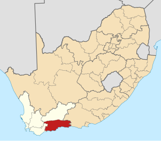
The Garden Route District Municipality, formerly known as the Eden District Municipality, is a district municipality located in the Western Cape province of South Africa. Its municipality code is DC4.

Kareeberg Municipality is a local municipality within the Pixley ka Seme District Municipality, in the Northern Cape province of South Africa. The name originates from a mountain range in the region, the Karee Mountains.

Albert Luthuli Municipality is a local municipality within the Gert Sibande District Municipality, in the Mpumalanga province of South Africa. It was named after Albert Luthuli. Carolina is the seat of the municipality.

Molemole Municipality is a local municipality within the Capricorn District Municipality, in the Limpopo province of South Africa. The seat is Mogwadi.

Lephalale Municipality is a local municipality within the Waterberg District Municipality, in the Limpopo province of South Africa. The seat is Lephalale.
Thabazimbi Municipality is a local municipality within the Waterberg District Municipality, in the Limpopo province of South Africa. The seat is Thabazimbi.

Musina Municipality is a local municipality within the Vhembe District Municipality, in the Limpopo province of South Africa. It is the northernmost local municipality in South Africa. It borders Botswana, Mozambique and Zimbabwe. The seat is Musina.

Ba-Phalaborwa Municipality is a local municipality within the Mopani District Municipality, in the Limpopo province of South Africa. The seat is Phalaborwa.

Steve Tshwete Municipality, formerly Middelburg Municipality, is a local municipality within the Nkangala District Municipality, in the Mpumalanga province of South Africa. The seat is Middelburg. The local municipality was one of the four to have passed the 2009-10 audit by the Auditor-General of South Africa, who deemed it to have a clean administration.

Ditsobotla Municipality is a local municipality within the Ngaka Modiri Molema District Municipality, in the North West province of South Africa. The seat of the municipality is Lichtenburg.

Greater Taung Municipality is a local municipality within the Dr Ruth Segomotsi Mompati District Municipality, in the North West province of South Africa. The seat of the municipality is Taung.

Metsimaholo Municipality is a local municipality within the Fezile Dabi District Municipality, in the Free State province of South Africa. Metsimaholo means "big water" in Sesotho.

Newcastle Municipality is a local municipality within the Amajuba District Municipality, in the KwaZulu-Natal province of South Africa.

Umzimkhulu Municipality is a local municipality within the Harry Gwala District Municipality, in the KwaZulu-Natal province of South Africa. Umzimkhulu is an isiXhosa and isiZulu word meaning "big/great house". Prior to the Twelfth Amendment of the Constitution of South Africa in 2005, confirmed by the Thirteenth in 2007, it was part of the Eastern Cape.

Blue Crane Route Municipality is a local municipality within the Sarah Baartman District Municipality, in the Eastern Cape of South Africa. The municipality is named after the South African national bird, the blue crane.

Elundini Municipality is a local municipality within the Joe Gqabi District Municipality, in the Eastern Cape province of South Africa. The name originates from isiZulu and refers to the Drakensberg Mountains.

Msinga Municipality is a local municipality within the Umzinyathi District Municipality, in the KwaZulu-Natal province of South Africa. Msinga is an isiZulu word meaning "a current in the sea where air movement causes ripples on top of the water surface and ends up influencing the nearby climatic conditions through its breeze". The municipality is largely located in deep gorges of the Tugela and Buffalo rivers, isolated from the immediate surrounding municipal areas. The population dynamics result in a growing rural area and a declining urban area in the municipality, contrary to most other areas in the country. This can be attributed to the fact that the urban areas of municipality are very small and are unable to provide the normal range of goods and services provided in urban areas.
Nkonkobe Local Municipality was an administrative area in the Amatole District of the Eastern Cape in South Africa. The municipality is named after the Winterberg mountain range, Nkonkobe in isiXhosa. The seat, as well as most offices, of the Municipality are in Fort Beaufort, but the Council's chambers in Alice are generally used for council meetings, being better equipped. Other towns served by the municipality are Seymour, Balfour, Hogsback and Middledrift. After municipal elections on 3 August 2016 it was merged into the larger Raymond Mhlaba Local Municipality.

Senqu Municipality is a local municipality within the Joe Gqabi District Municipality, in the Eastern Cape province of South Africa. Senqu is the Sesotho name for the Orange River.
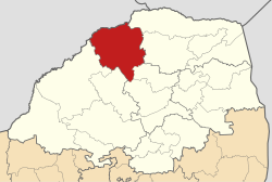
The Blouberg Local Municipality is a Local Municipality in Limpopo, South Africa. The council consists of forty-four members elected by mixed-member proportional representation. Twenty-two councillors are elected by first-past-the-post voting in twenty-two wards, while the remaining twenty-two are chosen from party lists so that the total number of party representatives is proportional to the number of votes received. In the election of 1 November 2021 the African National Congress (ANC) won a majority of thirty-three seats.